Wednesday, September 29, 2010

Topping up the mileage on Muddy byways and the Lodes Way - again

There has been a blitz on burglars and bike thieves with Police now holding over 150 bikes (and other things; computer, laptops and the like). They will hold an open day for anyone who has had property stolen during the last year to return stuff to their owners. (Although you won't be able to walk away with it on the day). Apparently they have charged more than 50 people with 192 offences. That is quite a haul, according to the Cambs Police webpage around 2,500 bikes were stolen in the city in 2009 and they recover 700-800 bikes a year.


On a less pleasant matter - a 12-year old girl was pushed off her bike and a 44-year old woman from Chatteris cautioned for common assault. I wonder if road rage is on the increase or not. I would classify this as road rage, since it was aggressive behaviour by a driver of a motor vehicle. Interestingly Wikipedia also has a definition for "Bike rage". I wonder what is going on, is there an increase in "road rage" incidents and what factors drive it. Is the problem correlated with the general stress of living or the increase in traffic congestion. I think that it is related to the latter and that the roads then become seen in a territorial way by road users -motorists and cyclists alike. Which then leads to territorial conflicts - this does not provide an excuse for transgressors but does make me wonder. I have been sworn at by drivers when cycling, I have been shouted at by youths passing close to me as they sped by in their cars. I have had water thrown at me (I hope it was water!). I have had cars deliberately drive at me even when I have the right of way on the road.


Small wonder that when I am looking to go on relaxing ride I tend to head to places where there are few motor vehicles and those there are tend to be very courteous. I find tractor drivers always wave their thanks and are happy to pull onto the verge to pass a cyclist. The country lanes are also much quieter, perhaps road noise is also a factor in inducing road rage! Talking of quiet places the Wicken Fen Vision has gained public support in the shape of a Number 10 petition. I am in favour and think that the changes made already have been most welcome. This includes the routing of NCN 51 through Wicken Fen and the more recent creation of the Lodes Way route. Here is a Lodes Way Brochure (in pdf format). If you look at the picture on Page 2 of the horse rider and cyclist passing each other on a small bridge - take my advice to cyclists and wait for the horse to go by.)


Now I am aware of the contradiction in my thinking - if the Fen is made more accessible then more cars will be attracted into the area and I don't like cycling with cars if I can help it. However I do believe it is possible to make the area open to horse riders, walkers and cyclists with peripheral access points for those unable to get to the Fens without their tin boxes. I also believe that whilst discouraging more cars into the area we must also ensure we don't make it worse for those living and working in the area. It is difficult to live in rural areas without a car we mustn't clog up their lifeline roads. I am impressed that visitor unmbers seem to be increasing, well if the number of cars in the Wicken Fen car park is anything to go by.


The Fens have a lot of history and have seen a lot of change. It now turns out that the last eel catcher in the area might be banned from following his calling for 6-months of the year. Stocks of eels are low and a ban for 6 months of the year is being imposed to try to protect the eel population. However if you follow the link you will see that there are sound reasons for modifying the ban on the chap involved to allow him to carry on. If you don't follow the link, well, it is to do with his method of trapping eels using willow traps.


So back to some cycling, the route is only a minor modification of others I have made before. This heads out along High Ditch Road before taking to byways to get to Lode and the Lodes Way - but this route heads off to Upware and then to Wicken Fen before returning along the Lodes Way through to Bottisham and NCN51. There is not too much road and most of the road there tends to be quiet country lanes. The route is around 50Km/ 30 miles and the elevation varies from 0m to 19m above sea level - so there are no hills to climb. One word of caution - the byways are great when it is dry but can become very slippery after rain - I almost fell of my Marin Hybrid with 25mm tyres at one point (I was getting too cocky and speeding along without paying any attention to the track.)


Cambridge Lodes Way Loop 4 Annotated.jpg


One of the things I like about the Cambridgeshire area is the number of information boards around and about, some in remote places, that give a flavour of the history of the area. Fen Ditton, at the start of the ride is one such place. The board indicates the the places was originally called Dittone - "the village by the ditch" - where the ditch in this case was Fleam Dyke, a pre-historic iron-age defensive construction. (In fact it is one of several such earth works in the general area.) I am ashamed to say that I have not really noticed the visible earth works alongside High Ditch Road - next time I must pay more attention. I can recommend the Ancient Shepherds in Fen Ditton, although I cannot find a website for them - is it just me or are pub websites buried under the large number of pub and restaurant catalogue websites, many of which I find of limited value. If you read the link one reviewer seems more worried about older male executives dining with pretty younger ladies than the Pub. I like it (the pub) and so does my wife - in fact she was there yesterday with a friend and they both enjoyed their lunch.


P1180800.JPG


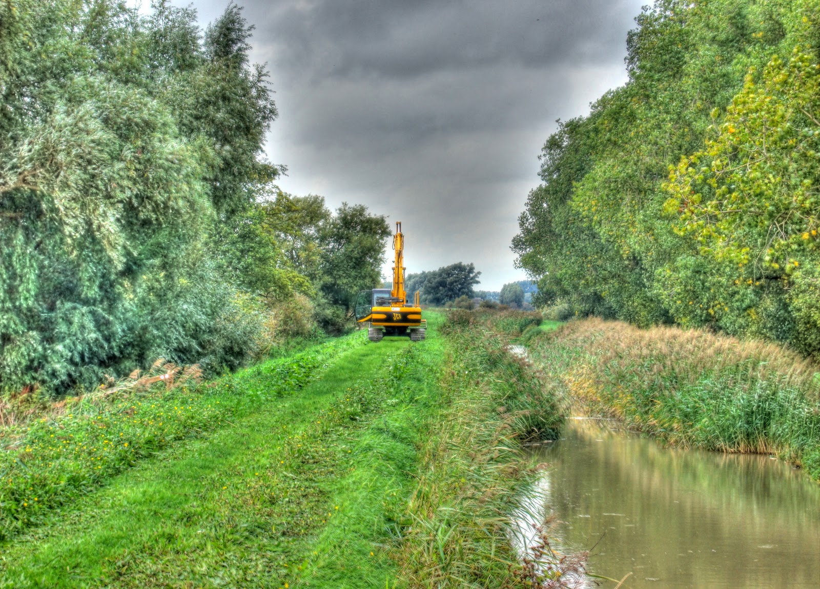
The byway (Low Fen Drove Way) has quite a few potholes along its way and on this day they were filled with water and so best avoided. I don't mind getting wet - I draw the line at bouncing over the handlebars though. I had to stop for this disk harrow (well to take a picture of it). Photomatix has just been upgraded to Version 4.0 and this is the first picture I have created using it. I am impressed with the changes /improvements/additions already. Amongst other things there are improvements to the noise reduction and the way in which ghosting is handled.


P1180801_2_3_4_5_6_7_tonemapped.JPG


After the gravel track the byway become a more traditional farm track - which was in pretty good shape considering the rain. It was quite hard cycling though and the mud was sticky and clogged up my bike wheels. There is talk of siting a Waste Water Treatment plant near here though.


P1180815_16_17_18_19_20_21_tonemapped.JPG


This is not the byway but heads off towards Allicky Farm (according to the map). Those wheel tracks are either MTB tracks or perhaps the small motorbikes I saw the other day.


P1180822_3_4_5_6_7_8_tonemapped.JPG


There are quite a few pylons in the area and already you can see this field, which was not long harvested now has the green shoots of the next crop showing.


P1180836_37_38_39_40_41_42_tonemapped.JPG


My route then followed parts of the Harcamlow Way on through Lode and White Fen. Whilst speeding cycling quite fast along one of the paths I was too busy looking around me and my front wheel skidded away from me as I inadvertently changed ruts. For one brief moment I planned how I was going to fall before controlling the skid - it made my heart be a bit faster for a while though. There are quite a few fields along the Upware Road being used for growing turf - this is one.


P1180843_4_5_6_7_8_9_tonemapped.JPG


The Upware road has recently had some roadworks to flatten out the dips. although the cracks in the tarmac were not fixed - tough on cyclists, good for speeding cars!


P1180850_1_2_3_4_5_6_tonemapped.JPG


It is that time of year again for Harvest Services - this is the road leading to the Little Chapel on the Fen. For a report of last year's service see page 7.


P1180857_58_59_60_61_62_63_tonemapped.JPG


I mentioned that the start of the off-road section of NCN 51 through Wicken Fen (on the village side) had been re-surfaced. At the time I had to give it 5/10 - could do better. Well the path has now been fenced to segregate the construction traffic building the new Windpump. The start of the shared-path now only gets 3/10 - it has very loose large lumps of gravel and the bike squirms all over the place. You have to go quite fast to get the bike over the lumps (well I did anyway) but it has been temporarily narrowed and speed on a bike and walkers don't mix.


P1180864_65_66_67_68_69_70_tonemapped.JPG


The start of the new bit of the Lodes Way occurs after crossing the old footbridge over Burwell Lode. There are ramps to help guide the bike wheels up the steps - but it is steep and my bike skidded down and then the back wheel tried to go over the handlebars.


P1180871_2_3_4_5_6_7_tonemapped.JPG


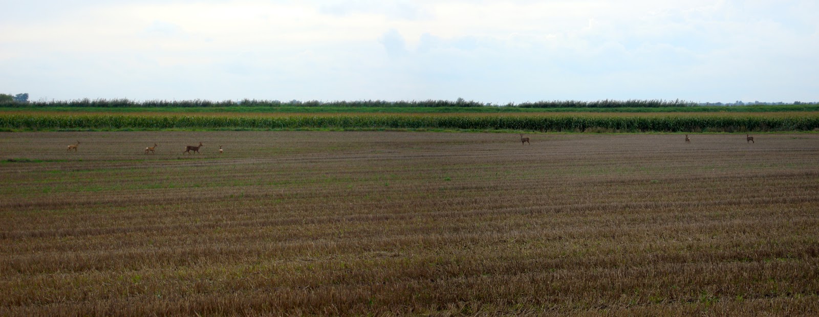
The path along Lodes Way through Burwell Fen (as it is signed) seemed a bit soggy and slower going than usual - although that might just be me. There is already signs of damage on the path, with fairly large hoof-prints in the track as you approach Reach Lode Bridge which is surprising. I did see deer on Burwell Fen, but as I have taken pictures of them quite a few times now I didn't bother this time.


I also did not take any pictures from Reach Lode Bridge either - partly because I have taken quite a few already and partly because it had started to rain (er actually mainly because of the rain).


The rain was not too bad though so I took a picture of this chap walking his dog down Swaffham Bulbeck Lode. I was on the new bridge and he was on the old footbridge. It shows the importance of circular routes.


P1180878.JPG


I also passed a person who is a regular car-based dog walker on White Fen Droveway.

Tuesday, September 28, 2010

Council to begin Cambridge Guided Busway Inspections

September 28: This is definitely a route I have taken before - available on BRT here. It is a little over 50Km/ 30 miles and no hills to speak of. After looking at my total for this month I though it would be a good idea to use the Cambridge Cycle Superhighway Cambridge Guided Busway (CGB) to get a bit of distance under my belt and hit a total of 1,000Km/ 625m for September- all being well over the next couple of days. This route is a good one to get a bit of distance cycled as it is quite fast and I know it well enough not to worry about getting lost! It was also warmer today than yesterday and very little wind to speak of so I reverted back to wearing shorts to cycle in - a good choice. (It was around 16C so I still wore some socks and long-fingered gloves. I am not sure I really needed to though.)


No sooner had I returned and loaded up the pictures onto my Computer than the CGB appeared in an article on the Cambridge News Website: "Council starts own guided busway inspections". Perhaps I ought to offer my services. Apparently there is concern that there might be other hidden defects and despite the Contractors not providing Construction Certificates the Council feels the need to push ahead in case there are problems beyond those already identified.


Cambridge to St Ives Annotated.jpg


Before I set off there was a spider hanging in a web outside the window so I took a picture of it just hanging there. It was the other side of the window, so it was not well-lit and life was to short to try the flash out and there would have been glare reflected back in any case. Next time I will try to do better!


P1180714.JPG


My route takes my along Gilbert Road where there were 14 cars parked in the Cycle Lanes - if anything I think Cycle Lanes encourage cars to park there. There even seemed to be a couple of cars for sale parked along the road. Then I followed NCN51 between Oakington and Longstanton, yes the one banned to motor vehicles. Whilst cycling along the banned bit, three commercial vans and one estate agent's Smart car passed me and one car was parked up with the driver reading a newspaper. So the clamp-down has had an effect, but there are still vehicles using it. I also passed three cyclists, although it is not statistically sound, I am convinced that I have seen more cyclists use it after the police clamp-down. (I also saw cars heading in that direction when I was either side of the actual banned bit, which are unlikely to have vanished or driven off across the fields - but I did not count them. The road has, as been commented on by the Cambridge Cyclist (see previous link), got some nasty potholes.


After Longstanton I took the Over road rather than the NCN51 route, it climbs up Windmill Hill past a Communications Tower and Windmill. On the way I passed this burnt out car - my guess is that it was stolen and then when they had finished with it the thief (or thieves) set fire to it to destroy the evidence. This one seems to have survived better than some cars so I could be wrong and it might have been a spontaneous car fire. The number plates look as if they were removed though.


P1180721_15_16_17_18_19_20_tonemapped.JPG


The view of the CGB from Windmill Hill Bridge., as you can see it was a grey day. Cycling past the CGB on the Over Road between Swavesey and Over I noticed a red sign indicating Bridge Closed. I was not sure which bridge but thought it might be the one over the River Great Ouse near St Ives. I decided to cross that bridge (or not) when I came to it. There were alternate routes via Fenstanton I could back track back onto the CGB.


P1180728_2_3_4_5_6_7_tonemapped.JPG


After getting back onto the NCN51 in Swavesey I turned off onto the Fen Drayton Lakes Nature Reserve. This is the Trout Pond I think. For an area that gets easily flooded it seems a bit short on water.


P1180735_29_30_31_32_33_34_tonemapped.JPG


The Reserve started as Fenland then was Farmland before being quarried for sand and gravel. The lakes are man-made as a result of the extractions. It became an RSPB reserve in 2007.


P1180736.JPG


At the time I crossed the busy roundabout on the outskirts of St Ives it wasn't the rush hour and I got across with hardly any waiting. Fortunately although the CGB is not operational the traffic lights built where the CGB crosses into St Ives are so crossing back over the busy Harrison's Road was also straight forward.


I stopped to take a picture of this Pill Box opposite the St Ives park and ride car parking area. These are part of our History I wonder if they qualify as worthy of preservation?


P1180743_37_38_39_40_41_42_tonemapped.JPG


This is the first lake you come to after travelling along the CGB - it seems to be nameless on the OS and OSM maps.


P1180757_1_2_3_4_5_6_tonemapped.JPG


I rather liked the simple reflections of the trees on an otherwise grey background.


P1180764_58_59_60_61_62_63_tonemapped.JPG


Yes the closed bridge was (actually will be) the bridge over the River Great Ouse. the piece of paper stuck to the sign indicates that it will be closed between the 4th of October and the 4th of November. It is good that some warning is given, I wonder if there will also be a diversion signposted when the time comes. A search of the Internet did not throw up any reference to this closure (well not one I could find quickly anyway). I assume it will be either to allow the aforementioned inspections or more likely to fix the problems - section 1.4 and 2.2 - 2.5 of this word document. On reading the document it actually refers to the bridge as the River Great Ouse Viaduct (with expansion joint issues). paragraph 2.5 suggests that BAM Nuttall will order and install the required joint. I guess this is when they will install it (or them?). The Viaduct weighs around 2,700 tonnes and sits on eight large concrete supports and took 18 months to complete. The old one can be seen here. An interesting report with some detail on how cost overruns are to be shared, courtesy of www.noguidedbus.com.


P1180771_65_66_67_68_69_70_tonemapped.JPG


The high quality mud path cycle way - looking back after I cycled through it. The path gets easily chewed up by maintenance vehicles and requires care to cycle along at this point.


P1180778_2_3_4_5_6_7_tonemapped.JPG


The high quality paddling pool cycle way has been fitted with sheep dips to ensure that visitors bringing their flocks of sheep to market in St Ives along the CGB don't bring any nasty diseases. I cycled along the bank to the right of the pool. It was a muddy track but easier to get on than climb up onto the concrete tracks. It would not be easy on skinny racing tyres though.


P1180785_79_80_81_82_83_84_tonemapped.JPG


The other areas of the Cycle way that are prone to staying dry flooding were muddy but not as bad as the last tow examples. I really do wonder what there is in store for users of this high quality path. Why on earth does no-one seem to know. The rest of the CGB path was ok down to Histon where it is going to get a tarmac surface. Mind you there are stretches of the CGB where rabbits seem to be desperately trying to burrow into the foundations. Perhaps that is why they left the Pillboxes - they will use them as shelters to stalk and shoot the rabbits! (This one is near the Oakington Airfield (as was).


P1180799_3_4_5_6_7_8_tonemapped.JPG


There you have it - no visible progress (to me anyway) but signs that indicate that just maybe one of the 6 faults is going to get fixed. My money is on the Shared-use path getting somehow forgotten and then everyone pleading that there is no budget anymore. Well in my view there shouldn't be a budget for incompetence. A quick read of the CCC report of the 28th September 2010 suggests that the surfacing of the cycleway between Milton Road and Longstanton will have to wait until the CGB is finished as BAM Nuttall have thrown their toys out of the pram won't co-operate with the Council on another Contractor doing the work. The report is also from www.noguidedbus.com they are so much easier and quicker to find there than on the CCC website, have they not learnt how to organise data so that it can be easily found - or is it deliberately obfuscated on the CCC website?


Finally - I passed 8 cyclists on the concrete path and a few walkers and 6 cyclists on the cycleway. Most of those using the Cycleway were school-kids and between Histon and Cambridge.


Geeky Cycling thoughts

As the weather changes from Summer to Autumn (Fall) I find I have to change the way I think about cycling. For one thing I have to wear more clothing. Well I don't have to, but whilst I would not think of myself as a fair-weather cyclist I do like to be warm enough. Also as the days get gloomier and the nights draw in both lighting and bright clothing become important factors. Mind you, you pedestrians should also wear reflective materials in the dark as well - Highway Code Rule 3. It is funny but cyclists get derogatory comments from motorists for their stylish Lycra wear, but then moaned at for wearing fluorescent yellow sashes - the classic look for a nerdy cyclist. (Sorry to those of you who do this - my approach is to wear a full fluorescent yellow jacket and shut my eyes!)


Why does this matter - well because there are people in charge of fast metal boxes and they need all the help they can get to co-exist with other road users. The good news is that cycling deaths are continuing to fall in 2009. The rather sobering news is that 2,222 people were killed in road accidents last year along with 24,690 seriously injured (out of 222,146 injured people). Out of this total there were 104 cyclists killed and 2,606 cyclists seriously injured. The challenge though is raw numbers do not tell the whole story about cause and effect. (Perhaps threre were fewer cars about - actually there were.) Worryingly, for me anyway, 25 cyclists were killed and 310 seriously injured by drivers passing too close. Also exceeding the speed limit was seen as a contributory accident in 5% of reported accidents and 17% of fatal accidents.


I also saw a report that suggested that Road Injuries and fatalities cost the UK economy £33bn in 2009. Yet Government targets for reducing road deaths and serous injuries only run until 2010. I know the new Government is busy - but this is rather worrying. Interestingly another report suggested that the "vast majority of drivers were found to support lower limits" and it also suggested that enforcement was the key measure to help motorists drive more slowly. Which of course is not the direction being headed in by the current Government. Apparently Speed cameras "don't stop real danger motorists" and more patrols are needed. I do think that average speed cameras have had a major effect on reducing speeding on motorway roadworks and up the A14 between Cambridge and Huntingdon. Mind you I would not cycle along that bit of the A14 - far too noisy. It was sad to see that Harry carpenter died after "falling down the stairs and suffering a catastrophic head injury". However he had an acute heart attack at the top of the stairs which caused the fall. No call from the Mail for stair-users to wear helmets though.


Talking of Cambridge - you can now get a free iPhone app, developed in Cambridge developed as part of the www.cyclestreets.net website and is based upon OpenStreetMap data. Unfortunately Cambridge is only the second-best city for cyclists according to the Campaign for Better Transport. There is also mention of the long-overdue Guided Busway and that when it comes into operation it might make it harder for cyclists in the North of the City. Cambridge Colleges also provides rich pickings for thieves - with bicycles topping the list of stolen items - and the Judge Business School coming second for Colleges suffering thefts. Humm I park my bike there sometimes - I'll have to make sure my locks are up to the job. Mind you even bikes locked up at the Cambridgeshire Police Headquarters are not that safe. Two MTBs were stolen from the bike sheds, but they did note the Frame number of one of the bikes when it was being taken and caught the culprits and recovered the bikes although some bits had been put on other bikes.


Have Google invested in the future of cycling? It would keep you dry but I am not sure how you would overtake though. Why am I rabbiting on about this - well I read Cycling stuff, for amusement and inspiration. How about this 6 months to cycle around the world and break the speed record. during his trip he used 13 tyres., 11 chains and 3 sets of bottom bracket bearings. I think I'll stick to NCN routes around the UK.


Talking of inspiration my cycling has been a bit patchy of late because of holidays and weather and other stuff getting in the way. So I thought I'd better check my stats for the year to date. Actually it is not so bad. As of the 27th of September I have cycled 9,192Km and based upon a daily goal have a surplus of 381Km in order to reach my target of 12,000Km for the year. August was a tricky month though with a total distance of only 547Km, it has picked up in September with a total so far of 878Km.


Here is a chart from my Cycl;ing Spreadsheet (I know I am a geeky cycling nerd - but it keeps me cycling!). The chart shows the date and distance cycled during the year. I have only had one long distance ride with a 200Km run in April. In fact I have had very few 100Km+ rides this year compared with other years. I would normally expect to do one or two a month.


Cycling to date Sept 27 2010.JPG


Still there is still time to go in the year and after the last couple of days of rain it looks dry out there - I think I'll go for a ride!

Saturday, September 25, 2010

Autumn brings grey days to the Fens (and push-me-pull-you deer)

September 25: I was not going to bother putting up a map and Bike Route Toaster Link for this ride as I thought I had already done it before. (Indeed I may well have but couldn't find it.) So here it is - yet another loop out of Cambridge using the Lodes Way as one of the legs - or rather using the Lodes Way to connect the loops.


Saturday is a day for getting the shopping done for the week along with any other chores and then getting out to ride. It is funny I thought it was September, but my calendar must be wrong - they had mince pies and Christmas Puddings on sale in the Supermarket. Although as my wife pointed out they also had Hot Cross Buns for sale - so their calendar must be completely haywire.


Once the chores are done then the incentive to ride is that I can catch up on the Archers, a radio soap opera that has been running for 60 years, having started in 1950 by the BBC's then Midlands Home Service. It hit the mainstream on January 1st 1951 when it was broadcast to the UK. It started as five 15 minute programs a week and is now broadcast 6 times a week (still 15 minutes for each program). Just to make it clear this program started before I was around, I am not that old. I started listening to it probably when I was around 16. At one stage I used to listen to the Omnibus program, the week's episodes lumped together into a Sunday morning program. (It was an excuse to have a lie-in and listen to it in bed.) Later, when driving around was part of my job I would listen to the evening editions of the program, broadcast at 7.15pm. The nature of the program is that you can still follow it even if you don't hear all of the programs. Although it can be a bit confusing sometimes if you do miss key moments.


With the advent of DAB (Digital Audio Broadcasting) in the UK in the 90's I acquired a Psion Wavefinder in around 2000, it connected to my PC and allowed me to "record" DAB Radio programs onto my PC and then to transfer them onto my MP3 player. I now download the Archer's BBC Podcast and listen to it on my MP3 player (since it became available in February 2009). By Saturday I have a week of the Archers programs recorded and listen to them when out cycling, either on Saturday or Sunday. Generally I listen to another program first so that by the time the Archers is playing I have gotten out of town and into the country so the program does not get drowned out by the noise of traffic.


For this run it gets quieter by the time I am on the Lower Fen Droveway. The route is around 50Km/30 miles in length and as you might expect only reaches a maximum elevation of 20m (and a minimum of 0m) so there is not much climbing. It has gotten colder though as Autumn (Fall) approaches. In fact I wore leggings for the first time since the Spring (and a jacket and long-fingered gloves and socks).


Cambridge Lodes Way Loop 3 Annotated.jpg


The weather was quite cold and gloomy, although I was not really worried about lightning (just the possibility of rain), However I could not resist adding this cartoon from xkcd - "A webcomic of romance, sarcasm, math, and language." A link to show the image is included on their Website so I hope that putting it in my Post is acceptable to the Author.


I did pass some cyclists as I cycled around Lower Fen Droveway, I also saw what looked like some small motorbikes beings ridden on one of the fields by Snout Corner as well. I don't actually show it on the map trace, when cycling I sometimes cycle down no through roads to see what is there. This picture is Dock Lane in Horningsea, it leads to the River Cam. This house was up for sale by auction the last time I passed this way. The garden around it has been cleared so I assume it has been bought and is in the process of being renovated.


P1180654_2_3_tonemapped.jpg


This is Headlake Drove, looking back towards Cambridge - you can just about see where the dips in the road have been filled and the cracks alongside left to keep cyclists on their toes (or should that be pedals).


P1180657_5_6_tonemapped.jpg


It was looking a bit bleak when I cycled through - Upware to the left, Reach to the right and Lodes Way straight on. I also discovered a single jelly baby in my fluorescent yellow jacket - an unexpected treat bit of energy.


P1180660_58_59_tonemapped.jpg


I passed a couple more cyclists on Lodes Way, one looked as if she was just out for a cycle in the wind and the other was walking (actually more like running) quite a large dog. After reaching the end of Burwell Fen as the NT signs show but appears to be Hundred Acres on the OS map I hauled my bike over the footbridge at High Bridge (over Burwell Lode). The challenge is that this bit of the Lodes Way does not really look like a real shared use path and so cars park across it


P1180663_1_2_tonemapped.jpg


I cycled around Wicken Fen along the Maltings path and then back in via the entrance way. There were loads of cars in the car park. It surprises me how popular the Reserve is, and yet you don't see that many people on the outskirts of the reserve. Here is a windpump that rather than pump water away is used to pump water into the Sedge Fen to keep it appropriately wet. However it is being replaced by a modern windpump.


P1180666_4_5_tonemapped.jpg


There are already signs of the "builders" having moved in to construct the new windpump. When you cycle into the reserve there are various signs warning of construction work and these "crates". The company that appears to be doing the work is Birse Civils, but a quick web-search does not seem to throw up any information.


P1180669_7_8_tonemapped.jpg


On the way out of Wicken Fen on my way to Burwell I passed some deer in the field.


P1180670.jpg


Including this rare push-me, pull-you deer with two heads!


P1180675_3_4_tonemapped.jpg


For a road I have moaned about I actually quite like cycling along Newnham Drove between NCN51 and Lodes Way (NCN11) despite its very bumpy surface. The signpost is labelled as (11) - which shows it gets you to NCN11 but is not itself NCN11. This implies that the road I was on - Weirs Drove was still NCN11 as the sign further along shows it as "11" and "51". Or am I making too much of the signing?


P1180678_6_7_tonemapped.jpg


I saw two more deer as I cycled along Newnham Drove at the time I though they might be the same two I saw - but Burwell Lode is in the middle, so unless they swam or used the footbridge they couldn't have been.


P1180679.jpg


The gates across Newnham Drove to get to Lodes Way are still locked. I once again squeezed through - but because I was wearing more clothes the squeeze was a bit tighter. I carried on up to Burwell Fen Farm and took a few pictures.


P1180684_2_3_tonemapped.jpg


This is the inside of one of the barns - I was hoping to see what the construction was like (MikeC mentioned it was a rare form of wartime construction.) The buildings were quite dark and I assumed that taking a multi-exposure picture would make all visible. I had not reckoned on lens iris artifacts appearing in the picture though (the hexagons).


P1180691_87_89_tonemapped.jpg


A trip along Lodes Way would not be complete without some pictures taken on the bridge. Don't worry I will tire of this soon.


P1180699_3_4_5_6_7_8_tonemapped.jpg


A closeup of Split drove taken from the bridge - the signpost indicates the bridleway called Straight Drove from Reach to Upware - a route I seem to have been neglecting since the opening of Lodes Way.


P1180706_0_1_2_3_4_5_tonemapped.jpg


Instead of following Lodes Way along Whiteway Drove I took Rail Drove a track heading north alongside fields at the bend in the road by Highbridge Farm and then onto the byway alongside Swaffham Bulbeck Lode. As I reached the Lode the digger that has been working there was silhouetted against the sky. I think that it has been cutting the grass - but did not check to see whether there was a cutting tool on the end of the arm.


P1180707.jpg


The same picture (and 6 others) combined to create an HDR picture. Now the days are drawing in I must start thinking about taking sunset pictures and not relying upon HDR effects. I also need to check out my bicycle lights. I have used a variety of different rechargeable lighting systems over the years. I first upgraded from simple non-rechargeable lights when cycling back from work along country lanes in the evening. I found that motorists would rarely dip their lights when coming towards me. When that happens a cyclist is effectively blinded and the road all but disappears. The implications was that the motorist didn't see me! As soon as I started using brighter lights then motorists would dip their lights - job done.


The early ones used lead-acid batteries and filament bulbs and were not terribly reliable so a while back I got an LED light from Exposure Lights it was remarkably good for such a small unit. It got lost on some very rough track unfortunately, but not before I had bought another one. The light was called the Joystick and it is on its mk5 version this time around I am thinking of something more powerful for my off-road cycling. (These sorts of lights can be expensive, but they feature different power levels and it is my safety I am investing in.)


The challenge when cycling at night is what to do on shared-used cycle paths. The tend not to be very wide and often vegetation encroaches even further onto the path. So you need decent lights to see the path and make sure you don't run into hanging brambles, but when there are oncoming cyclists or pedestrians bright lights can blind them. So I "dip" my lights when there are oncoming cyclists, or at least I try to. Although most shred-use cycleways in the countryside tend to be tidal, with people going into Cambridge for work in the morning and out of Cambridge home in the evening I tend to cycle against the flow. So at the end of a ride in the early evening I am the one going into Cambridge against the flow.


For rear lights I use Cateye lights - generally the TL-LD1100 in flash mode and I carry a spare set of batteries. They reckon to have around 100 hours of battery life in flashing mode which is pretty reasonable and they are certainly noticeable


P1180713_09_10_08_11_07_12_tonemapped.jpg


Just after White Fen I passed a cyclist I had seen earlier towards Quy Fen, only this time he was walking his bike. It looked as if he had punctures in both the front and rear tyres. I offered him some help and some patches, but his plan was to walk through to Waterbeach Station and catch the train back. I think that he had tried to patch up his rear tyre, but it was going flat again. It can be incredibly annoying when you mend a tyre only for it to deflate pretty quickly, you start doubting your ability to fix any punctures when that happens. Hopefully it won't put him off cycling into the Fens.


My worst record was three punctures on a ride and I used up all my patches, at that point I was paranoid about getting another puncture and having to call for help 50Km/ 30 miles away from home. What I did was find a bike shop in a nearby town (Downham Market) and stock up on patches and inner tubes, just in case. Fortunately I did not puncture again on that ride.


Although the Autumn colours have not really become too evident yet, along the NCN51 on Newmarket Road just after Quy the trees/bushes alongside had very definitely taken on an Autumnal look.


P1180648_6_7_tonemapped.jpg


One thing I didn't mention was that when I put my leggings on they had a bit of a hole in the saddle area - which I did not notice until sitting on the cold saddle as I was setting off down the road on my bike. I couldn't be bothered to go back and change so kept having to readjust my position. The nose of the saddle kept catching, a reminder that not only do I have to check my bikes and lights ready for winter - but also my clothes. The worst thing is where a perfectly good pair of leggings or shorts is no longer any good because the elastic in the waistband is no longer, well, elastic. I blame the washing machine for getting too hot.

Eccentric cycling

September 23: I had a lunchtime meeting with a friend to discuss some ideas and at the time we set up the meeting I suggested the Dyke's End at Reach. There are a whole bunch of reasons; I like the pub, in the Summer the garden is a delightful sun-trap, in the winter they have a warming fire. The food and range of beers are good. Also, one of the most important reasons is it provides me with an excuse to cycle out into the countryside.


All that seemed great when a few days ago the weather was warm and sunny. On Thursday as the rain came down the idea lost a little of its brilliance. The trouble is my cycling has been a bit patchy for the last month of so. I am not sure quite where I am with regards to my target of 12,000Kms for the year and as the winter approaches it will get harder to cycle regularly. I record my cycling in a spreadsheet, which might sound a bit weird, but it helps to keep me cycling. The trouble is after August I have yet to update the spreadsheet - I have got the information on my computer just not in the spreadsheet. I have a Tablet as the "mouse" equivalent on my computer - a Bamboo Fun, although not as new as the one in the link and without multi-touch. I first started using CAD systems 30 years ago (A CALMA) and I like the precision of pen input - it is also great for editing photographs. It also allows me to hand-write stuff into my computer- so I keep my cycling data on a Windows Journal as hand-written notes. Normally I then add the info to my cycling spreadsheet every few days.


The person i was going to meet had already decided not to cycle out there and did offer me a lift - but it was too good a cycling opportunity, so with sandals, Lycra shorts and a rainproof jacket I set off. The rain was not too bad, more of a heavy shower and it was not cold so cycling in the rain was quite pleasant. I find once you decide you are going to get wet then it becomes easier - it is when you have you office clothes and no rain-jacket that it can get unpleasant. I used to cycle to school and occasionally I would get to school with wet trousers and they would have to dry as I wore them. I have also done that a few times in office clothes - normally after cycling to the Railway Station. The trick is then to get a seat on the train next to the heaters.


I had taken a fleece with me to put on if I was cold when I got to the pub - but did not need it. Another advantage of meeting in a Pub is they don't mind eccentric cyclists turning up - whereas restaurants would probably turn up their noses. The food was good and we had a lot to cover so the meeting went on for a while, until 2.30pm - kicking out time. By now the rain had stopped and so I decided to cycle the long way home from Reach through Burwell into Wicken Fen and then back along the Lodes Way. One snippet of information they have their own not-for-profit Broadband organisation in Reach - RaSP (Reach and Swaffham Prior Community Broadband + Upware.)


This picture was taken between Reach and Burwell where Burwell Road, Reach Road and Weirs Drove meet. Having seen changes in the NCN routing on the OSM Cycle map I wondered how the signage reflected the situation on the ground. It seems that the old NCN11 through Burwell and up to Wicken Fen is still shown as such as route [11] is still shown along Weir's Drove. I would have expected to see the route number in "(11)" if it were pointing the way to NCN11. Mind you the Cambridge direction also indicates NCN11 so who knows quite what system the signposts are following. At least we have them along with destinations and distances. The good thing is they are still being shown as NCN cycle routes!


DSC00373_1_2_tonemapped.jpg


As I was cycling along Little Fen Drove between Burwell and Wicken Fen I noticed 7 deer in the field alongside Burwell Lode. (I only had my small Sony camera with me - which is why the deer don't get much of a closeup.) The picture is made up from two pictures stuck together using Photoshop Elements though. I wonder if the rising numbers of deer is going to be a problem in Wicken Fen or a welcome indication of the Reserve being successful? (At least my unscientific observations are that there are more deer around.)


Wicken Fen Deer.jpg


I cycled along the Maltings Path into Wicken and then back through to the entrance of the Wicken Fen Reserve. They seem to have gotten the builders in and it looks as if some serious work is about to take place. Although I had a bit of time I was not really supposed to be just out for a pleasant cycle ride so as you can see not that many pictures got taken. It wasn't until I was half-way through Wicken Fen did I see an Information Board explaining what was going on. There is an old Windmill that is used to maintain the water levels in the Fen - but it is being replaced by a new wind pump to pump the water. Now this does not mean the old Windmill will be destroyed - just not used to pump the water. I imagine they will still keep it in working order though.


DSC00379.jpg


The roadworks along Headlake Drove had been finished and the dips flattened and some of the cracks in the road surface left untouched. So motorists will be able to drive faster and cyclists will still need to cycle with care - sounds a bit cock-eyed to me.


I took a picture of the digger on the other side of Swaffham Bulbeck Lode Bridge the day before, that work has finished and it is now on the North side.


DSC00382_0_1_tonemapped.jpg


I got home having really enjoyed cycling to my meeting - it is great to "overcome" the elements - whilst cycling home having dried out.