Friday, August 31, 2012

Cycling from Cambridge to Over and back, with two cameras

Sunday, 19th August 2012: I was going to title the Post “The last weekend of Summer!”. The temperatures we once again at the point where we Brits start moaning about it being too hot. I can see why the Ozzies call us whinging Poms. Personally I thought it was glorious and it definitely called for a leisurely bit of riding in the countryside. When I use the word leisurely it tends to mean I don’t want to have to cycle off into another county – although there is plenty of nice countryside around this county.

I reckon that one of the best off-road routes around Cambridge is Worsted Street, also known as the Roman Road from Cambridge to Balsham (and a bit further – Horseheath). It runs parallel to the A1307 – but is straighter.  By best I mean for general getting out and about cycling. The track can be tricky in places and muddy in others, but generally it makes for a pleasant, undulating traffic-free route along a “green road”.  However I have been there a few times.

Another excellent off-road route leads from Coton to Cambourne along a loosely interconnected bridleway. It is less straight than than the Roman Road and runs parallel to the A428.  It can be rather bumpy in places though and in places the path can be rather overgrown.  Another rather nice route is from Dry Drayton to Conington – but I digress.

The route I took, another of the unexpectedly good for  easy, off-road cycling starts at Histon and can take you as far as Aldreth, or across to Earith and then to Over. I didn’t go quite as far and went through Willingham to Over and then back along the cycleway alongside the CGB. The route I took was 46Km/ 29 miles and passes through some lovely countryside – although the tracks run semi-parallel to the CGB cycleway they undulate more and you are not quite so isolated from the countryside. Here is the Bike Route Toaster Link to the map below.

As it was a Sunday I took the long way to Histon and cycled up through Horningsea to Clayhithe and then back down alongside the River Cam before turning off to Milton and then along Butt Lane. The track out of Histon is a bridleway called Gun’s Lane. The first path is a heavily pea-shingled path which takes a bit of care and a low gear. After that you have a hedge either side.

What does surprise me is how rarely I meet people on this path since it is so convenient.

Gun’s Lane, just outside Histon

Here is the map of my route – it seems that the planned cycle way along Butt Lane has stalled. It has only made it halfway. I seem to remember it relied on some developer money. I can’t easily find any recent information here is a note form January 2011.  Although reference to it in Cambridgeshire County Council minutes go back to 2009.  Here is a link to a map  on a pdf document. Although you might think that half a cycle way is better than none I doubt that parents would allow their children to cycle along Butt Lane in the dark – it can be scary in the light.

Map of my ride – Over the field to Over and back on the smooth tarmac of the CGB Cycleway

Gun’s Lane is used by farmers to get to and from fields, some of which don’t have gates so you feel to be pretty close to the countryside. This wheat was ripening nicely – although I have no idea what the moisture levels were. Apparently modern Combines continuously monitor such things.

Wheat ripening alongside Gun’s Lane, Histon

As you can see it was rather like cycling between seas of wheat it seemed to spread for miles.

A Sea of Wheat ripening in the fields – Histon

As I have mentioned before what is also amazing is how little weed there seems to be in the fields of crops. Although there were some thistles near the edge of this field. There are various rules (and payments) associated with how farmers deal with the field margins.

Weeds along the edge of a field of otherwise uniform wheat

After Gun’s Lane you reach a road (between Westwick and Oakington) where the crossing is called Lambs’ Cross – which I assume was because sheep were herded down this route to market in Cambridge?

At this point the track becomes a byway and is called Rampton Drift. After passing a farm you climb a little bit. (The contour lines on the map are only at 10m so don’t worry.

A small climb, Rampton Drift

To the left you can occasionally see the Guided Buses “sailing” though the fields. Further off in the distance you can see the Communication Tower that stands alongside the CGB on Gravel Bridge Road. (I took two cameras with me because I wanted the long lens on my Lumix Camera – Micro Four Thirds (like and SLR but not),  I don;t really like swapping lenses in the field (literally in some cases) so but I like to have a wider angle lens with me as well. So I took my small Sony DSC-W200 for the wide-angle pictures. The first of the Lumix pictures is the previous picture and this one.

Gravel Bridge Road Communication Tower in the distance

After climbing the “hill” you drop down – although the track becomes even easier to cycle along.

Rampton Drift – “down the hill”

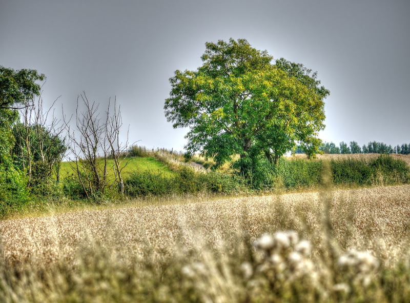
There were two things at this spot that appealed to me – the tree in the middle of the wheat field – this taken with the Sony. (Focal length at 17.2mm

Tree in a Wheat Field

This is the same tree – but taken with the Lumix and the long lens. As you might expect there is less in view, although the telegraph poles do stand out a bit more in this shot. (Focal length at – 100mm)

This is the other thing that caught my eye – a giant thistle (the afore-pictured tree is in the background. It looks rather like a Giant Ornamental Thistle.

Giant Ornamental Thistle

The same thistle – but looking down tre track.

Giant Ornamental Thistle

And yet another picture of the Thistle this time taken from a few metres ways and with my Lumix camera. (Focal length 177mm or 354mm it adjusted for a 35mm film). It nicely blurs out the background.

A view back the way I had come – the small lump in the ground – it looks steeper because of the longer lens though.

Looking back along Rampton Drift

After a short distance the track becomes Cuckoo Lane (named for the nearby Cuckoo Farm?). There used to be a pipe over the water the last time I cycled along here, Beck Brook.

Cuckoo Lane alongside Beck Brook

As I was cycling down towards Reynold’s Drove there was a man with a very large aggressive dog – he looked as if it was going to break free any minute. He pointed down the track as said go straight on in a way that made me think we was fearful the dog would break loose any second and attack me.

I did go straight on as that was the way I was intending to go  and then turned down Reynold’s Drove and then along a route that doesn’t yet appear on the OS map on WTP but is on the OSM map – a bridleway to High Street Rampton.  At this time of year it is quite overgrown.  I can’t remember getting stung but there were some thistles along the way.

Bridleway to High Street Rampton

I did think about going up the Aldreth Causeway, but wimped out and cycled through Willingham to over and then back down the CGB cycleway. There were loads of cyclists and quite a few walkers  out on the CGB path.

As it is a route I have taken lots of pictures of I just got on with the ride home – apart from this one picture of the miracles (what my sun used to call sunbeams many years ago).

Miracles beaming down onto the ripening wheat

I’d certainly recommend that route for a gentle ride out into the Cambridge countryside.

Thursday, August 30, 2012

Saturday a day for social cycling–chatting and Sustrans

Saturday, 18th August 2012: In yet another Survey, this time for the Government  “Cambridge tops UK cycle survey” as adults in Cambridge are more likely to cycle regularly than anywhere apparently with 52% riding their bikes at least once a week. So perhaps cycling facilities really do matter. I feel they matter way more than training. “Cambridge also fares well in offering alternatives to the car” in a survey by the Campaign for Better Transport.

One cyclist who might argue that the cycle facilities should be better policed is a former leader of Cambridgeshire County Council. She was fined for careless cycling after hitting a car parked partially in a cycle lane. That doesn’t really seem to be a very good message – I don’t mean her behaviour I mean not focusing on the illegally parked vehicle.  I hope there is an appeal.

Talking of local cyclists there is also an appeal for a cyclist who main have witnessed a fatal collision in June. It seems quite a while after the even to seek someone though.

Apparently despite recent news that the Police don’t want to Police 20mph limits they have cracked down on faster speeds. More than 200 drivers were caught in a week long crackdown. Apparently the Police were shocked, although I am not surprised judging from the behaviour of motorists I see – one way to get off apparently is to cry!  Police have also been able to catch a cyclist with cannabis – although it would seem that the cannabis is dulling the cyclist’s intelligence. A 14 year old boy has also become one of Britain’s youngest ever drink drivers. I am glad he has been caught but it is not that reassuring to think that 14-year olds drive at all. Mind you here is one 14-year old who calmly averted an accident – so they are not all bad.

It was a pleasant day, the chores were done and I had a week’s worth of the Archers and Ambridge Extra to listen to. It is no longer the “everyday story of country folk” but the recent story line menacing David Archer and his family seems to have resolved. Mind you we do have amniocentesis to go. Apparently the program is now a “contemporary drama in a rural setting” – so as is my wont I went for a ride in a rural setting to catch up. Maybe that ought to be my tagline – “contemporary cycling in a rural setting and Cambridge – mainly”.  At least I don’t have to worry about the price of milk although in a recent family survey I was the only one who knew the cost of a litre of milk. The Archers’ agricultural story advisor did hint that was going to be an issue  back in May 2011.

For me the rural setting for catching up tends to be a ride along High Ditch Road and then around  Low Fen Drove Way followed by a ride across the fields from Horningsea to Lode and then on, or thereabouts, Lodes Way to and from Wicken Fen. The precise route depends upon a bunch of things including the weather, both past and present and recent rides.

Before I forget – Lodestar Festival is on this weekend and check out these pictures of work on the Pylons near Wicken Fen. (It points to John’s Blog – the Wicken Fen Vision Warden)

My first stop was on the old railway bridge along High Ditch Road – there is no railway line now, it used to be the Cambridge to Mildenhall line. It was finally closed on the 19th April 1965.  What I have always found a little surprising is that despite the absence of any railway line – in this case for many years the bridges remain. I would have thought that it would be cheaper to remove the bridge rather than maintain it – but it would seem not. Apparently one of the issues is dealing with utility services that might run along the road and over the bridge.

This railway “line” is still  apparent, although heavily overgrown with various trees. One of the larger trees is an apple tree to the right of the picture. Although the apple trees at home don’t seem to have any fruit on them this one is laden. There used to be the Fen Ditton Halt here. I like to think the the apple tree has grown from the discarded core of one of the train’s passengers of yesteryear. UPDATE The Halt was not by this bridge so perhaps someone threw an apple core from the road or out of the carriage window).

High Ditch Road – bridge over the Cambridge to Mildenhall Railway Line – that was

Although I called it a cutting – given how flat it is around here the cutting is more rather organic.  This year’s harvest is well under way with fields combined and harvested and even ploughed – although there is still a fair bit to do.

I think that this is the view of Fen Ditton from the same bridge.

High Ditch Road Railway bridge

After crossing the old railway line again, just past the Dogs Home (but not shown on the map, Low Fen Drove Way becomes more of a hard-packed mud track – although we have had rain it quickly dries – although there were still some puddles. It doesn’t take much farm use when it is wet to cause the ruts to form though.

Low Fen Drove Way – near Snouts Corner

There is a concrete track parallel to the byway around Snouts Corner.  This is the view looking back onto it. The byway is the the right and the concrete track to the left. The byway gets extremely rutted and I think many people go via the concrete track – there is a gap to the right hand side of the gate.

Low Fen Drove Way and parallel concrete track

It was a surprisingly warm day and the skies were blue. I haven’t written about this picture, because I can’t quite recall where I took it – according to my GPS trace it might have been a picture where Low Fen Drove Way meets Biggin Lane.

Crops growing in the fields

After passing through Horningsea I was back  off-road, the fields both sides of the bridleway had already been ploughed.

Freshly ploughed fields in the Fens – late summer

There were quite a few cyclists and walkers around and there was a “traffic” census on Swaffham Bulbeck Bridge. Two people were asking users of the route various questions. “Where are you going” – which in my case was in a loop really, “how much exercise do you do”, “where are you from” and so on. They were quite chatty and we talked about the Lodes Way and how it opens up this lovely bit of countryside. I also suggested that having some more circular routes would be great as well. I could had stopped chatting all day except a whole bunch more cyclists turned up.

As it happened MikeC was just ahead of me and he had moved on when I turned up.  He then stopped at Reach Lode Bridge where I stopped for another chat. It was delightful standing on the bridge, the temperatures got up to 30C and as I sit here watching the rain now seems a distant memory.  There was also a delightful breeze blowing through as well.

Other cyclists came through and MikeC handed out Lodes Way maps. The two people in the picture also caught us up. They had stopped at the Census after me. They had come up from London for a night away and some cycling in the Fens. Originally they had planned to stay in Ely – but it was full so they were staying in Cambridge instead.

They had come up from London and had gotten off the train at Waterbeach (or cycled to Waterbeach from Cambridge, I am not quite sure). Having gotten to Waterbeach they then found themselves in no-cycling land, but managed to find a way across somehow. (I would imagine they came across from Horningsea to Lode). They were on their way to Ely. The NCN11 stub up through to Waterbeach is rather strange and does confuse visitors expecting to cycle to Ely and beyond.

Traffic Census on Swaffham Bulbeck Lode Bridge

It was a good job they didn’t serve beer on Reach Lode Bridge as I would have stayed there all afternoon. Mike and I cycled up to the footbridge over Burwell Lode and were joined by another cyclist of Mike’s acquaintance en-route. We said our goodbyes at the bridge and I went off exploring up Harrison’s drove. It was far worse than I had imagined – I thought there might be some puddles – but not warning signs. This is as bad as I have seen it.

I got off and walked – thinnish tyres and mud are not my idea of fun. I do appreciate the warnings though unlike these villagers who would prefer to have accidents it would seem. (There have been accidents as a result of the slippery ford – but it was a naturally occurring hazard.)

Harrison’s Drove, Wicken Fen – a mud track

I then cycled through Upware and along the main road before turning off along Way Lane and down Lower Road (NCN11) to Wicken Fen.

It turns out that although we seem to have had a lot of rain this year after the early drought in the US more than 35 states have declared disaster areas due to drought and bread, pasta and meat will increase in price. It is a good job the Fens are a productive area of farmland..

How about this for a summery picture.

Freshly bailed Straw - Wicken

All the chatting had made the time pass pretty quickly – so this was the last picture. But there are some  pictures in these links: Sarah Storey wins Britain's first gold in the Paralympics and a celebrity family out cycling  - although I don’t really know who they are! Here are some interesting “light” photographs as well – I can’t really draw well enough for that though.

Wednesday, August 29, 2012

Cambridge to Haslingfield and Back–with some satellite dishes thrown in

Friday, 17th August 2012: Well it was Friday, not five o’ clock, but certainly time to get out and put a few miles on the legs. The inclusion of the time is a passing reference to a TV programme called Crackerjack – check out the bit on catchphrases.

I say miles although for reasons that go back in time I actually measure distance in kilometres on my bike – I am getting ready for full decimalisation.

This ride seemed to be longer that it actually was – around 33Km/ 20 miles. I started off with no real plan and then as I was heading down towards Cherry Hinton I thought I would cycle along the bridleways out of Grantchester which took me down  Cantelupe Road to Haslingfield. I then returned on the Barton Road. Which is closed to through traffic – they are repairing the old railway bridge over the route of the Varsity Line.

There is still a lot of Combining going on and the section of NCN51 between Thorpe Way and the Newmarket Road Park & Ride looked like it had been hit by a dust storm.

NCN51 between Thorpe Road and Newmarket Road P&R

Here is the route of my ride. the Southern Section of the CGB provided an reasonable “escape” route. Whilst wiggle cycle routes through the quieter backstreets are better than nothing they leave a lot to be desired in terms of convenience and speed.

On the route to the Railway Station from the Tins it is pretty wiggle and there are roads to cross and lights to wait for. What most non-cyclists fail to appreciate is that stop-starting on a bicycle uses loads of energy. A bicycle is slow enough without making the journey even slower. (Actually I bet quite a few of the “I cycle and drive” brigade who then comment on how all cyclists are hooligans on wheels don’t actually do enough cycling to get that particular point.) A current bugbear of mine at the moment is just how long some light-controlled crossings make  pedestrians and cyclists wait.

Whilst I am thinking of it the crossing over Ditton lane into Fison Road can take quite a time – and be careful just because the light is red doesn’t mean cars and vans won’t barrel on through. The crossing on Church Road, Quy can also take quite a long time – as well. Indeed it can be so long that you often see people cross when the lights are still green for the non-existent road-users and then the lights turn red stopping the traffic flow for no reason.

Another bugbear of mine is this issue that 20mph speed limits “cannot be policed” and must have traffic calming to do the job. Talk about mixed messages. Mind you “Cambridge bike light crackdown snares more than 100 riders” shows that you don’t need traffic calming to catch cyclists. This scheme does actually encourage cyclists to get lights and avoid the fine – which then allows the Police to avoid the paperwork. The odd thing is that the article mentions that unenforceable laws are bad laws – as if the 20mph speed limit cannot be enforced- but it can if we choose to enforce it.

It does make me think that gradually there will be a separation of road “policing” away from the Police. There is already talk of allowing Councils to fine those who make illegal turns, yellow box violations and driving in cycle lanes. With Councils being short of cash it will also provide a ready source of income and employment. I wish they would stop motor vehicles parking on (or partially on) pavements.

A former county council leader (Cambs) was found guilty of careless cycling however there was no mention of the fact that the car she hit was illegally parked with two wheels on the cycle path. Lets get those fines rolling in and keep motor vehicles on the road – where they belong.

I feel the time has come to evolve the “punishment” for these types of offences. Talking of which I passed a team of people in Community Payback jackets – they might have been picking litter or gardening – I thought it would have been rude to stop and take a picture though

Perhaps those caught speeding in 20mph zones should be given the option of buying a GPS with speed limits programmed in to make it easier to obey the law. Or perhaps they should be forced to utilise GPS systems to monitor their driving behaviour.

The trouble is that the introduction of 20mph speed limits is way too piecemeal and road narrowing brings it own dangers for cyclists. Many motorists try to beat a cyclist, in front of them, to speed cushions ahead, the trouble is they then brake and swerve in as they get there.  It can be quite scary when you are the cyclist.

Why does it matter – well when you mix motor vehicles and cyclists on the same road generally it is the cyclists who come off worst. The severity of the injuries are correlated with the speed of the motor vehicles. Slowing down those motor vehicles therefore will reduce injuries for vulnerable road users. Hopefully this cyclist was not badly injured after his collision with a car.

Map of my route to Haslingfield and back

This was the cause of the dust storm – I waited for it to move on a bit before cycling through. What I wanted to avoid was getting dust in my eyes.

A Dust Storm on NCN51 between Thorpe Road and Newmarket Road P&R

Although it was a short ride and a Friday I found myself pedalling more than photographing.  I was amazed at how many buses there were now the bus stops are along the CGB by the Railway Station.

After all the stopping and starting it was rather pleasant to be on the Southern Section of the CGB – I even saw a few buses using it.  There is quite a bit of construction in the area so presumably it will change.  It seems that the Addenbrooke’s Access Road built to reduce the congestion caused by traffic entering the site from the South has been used to wage war on poor motorists. Enterprising motorists have been using it as a through route but apparently 8,325 of them have received warning letters telling them they have been naughty.

A Councillor has complained that the rules are too complicated and in any case people have paid their tax for this road. Well our taxes paid for the County Council Offices I think I’ll take up residence there. According to the news item only 50 people have actually been fined – so it would appear that motorists aren’t as stupid confused as we might think.

I didn’t go all the way to the end of the CGB and cut across through to the Grantchester Road and then along Bridle Way to the bridleway over the M11. Where I noticed some new public access signs and routes that I had not been on before. Now I must confess that I found the map a little confusing and misread the routes. 

I have since looked at the routes provide by the Trumpington Estate on their website and can where I went wrong. The red footpath blobs looked like bridleway size blobs to me. Mind you the keys are somewhat inconsistent. Here is the Barton and Grantchester map and the Haslingfield map.

To cut a long story short I cycled across from Grantchester to the bridge over the M11 at the top left of the map and followed the route down alongside the right-hand side of the M11 rather than the public bridleway along the left hand side. I then cross the M11 using the footpath where the “you are here” red blob is and then across to the bridleway pointing between the numbers “80” and “160” on the scale bar.

No harm done and I know better now – I will stick to the public bridleway on the other side of the M11. Sorry. I am a little confused still as I am sure that at least one of the footpaths alongside Bourn Brook is marked as a bridleway on the ground (See this link for the ride) – but on second viewing it wasn’t – sorry again.

Trumpington Estate – Permissive Access routes near Grantchester

As I cycled down towards Cantelupe Road the many satellite dishes of the MRAO came into view.  Did I mention I had my long lens with me (100 – 300mm which equates to 200- 600mm on a 35mm camera). There were some interesting buildings peeping out from over the hedge.

MRAO Satellite Dishes

So much sky and so little time – “you look up there and I’ll look over here”.

MRAO Satellite Dishes

After reaching Haslingfield I had no real plan so I started cycling North along the Barton Road. It wasn’t long before I reached a road closed sign. It will be closed from the 19th March to the 18th September 2012 for bridge repairs – although this link will change as it points to current road closures. Here is a link from Barton Parish Council that should not disappear. The bridge will then be able to carry 40 tons loads – oh joy for the residents of Barton.

Fortunately the bridge was open for vulnerable road users. I wonder whether there would be any support for a permanent closure. This picture was taken from the bridge. According to the OSM map it is the MRAO Arcminute Microkelvin Imager (AMI) large array.

Looking down from the Barton road Bridge over the old Varsity Line

And this is the view the other way. It isn’t modern art – just a different form of antenna array.

Looking down from the Barton road Bridge over the old Varsity Line

After that I headed back up to the Wimpole Road and then back into Cambridge along the Barton Cycleway. There are  two large roundabouts to cross on the M11 though. However a cycleway is far better than cycling along that road – in my view.

Monday, August 27, 2012

Wildlife in the garden (and house)

Hi – these pictures were taken sometime in the last week or so and not all on the same day. Apparently Britain’s insect population is struggling with the recent wet weather. (Bees, wasps, moths and butterflies.) Although I think there have been fewer wasps, butterflies and wasps in the garden we have had two swarms of bees “park up” in the garden. The other day we saw loads – well 50 plus – dragon flies flying around the garden. Which is a little surprising since our “pond” is only around 2m2 . A couple had the misfortune to fly into our living room – which has windows at each end – with only the windows at one end being open-able.

The good news is that my wife was a dab hand at dragon catching dragonfly catching. She used a large vase and managed to get them pretty quickly and then out before they flapped against the glass for too long.

I only have pictures of one of the dragonflies as I was elsewhere the second time around.

A dragonfly being rescued from the living room

The colours are really striking and the wings so fine.  apparently they are highly corrugated.

A dragonfly being rescued from the living room

I was surprised that the pictures came out OK since the dragonfly was moving and the vase glass was not exactly expensive optical glass.

A dragonfly being rescued from the living room

And finally we had a baby hedgehog do a runner across the lawn – it was sufficiently fast that by the time I had gotten my camera it was into the flower bed.

And finally – the rain has been good for something – Sunflowers.

Sunday, August 26, 2012

A ride around Oily Hall and Commissioners’ Drain

Thursday, 16th August 2012:  For me cycling is an activity that, quite simply, I really enjoy.  I don’t race and I’ve been fitter but whether it is a commute to the railway station or bouncing along a bridleway it is very satisfying,  I guess that it is the physicality and practicality  that appeals to me. It also works alongside my photography as well – which adds to the alliteration. (As well as being a three-part list.)

The strange thing is it is also a habit and if I don not keep that habit up it becomes easy to put off cycling. Which is why I work at cycling on a regular basis. It makes cycling the automatic and easy choice. Despite the cycle parking at Cambridge Railway Station being so crap it is still the best choice during the rush hour for actually getting to the station and I have managed to park my bike there or thereabouts the last bunch of times, albeit after wasting quite a lot of time, which saves me £7.70 or so in parking fees.

Cycling also gives me thinking time – which can help sort out issues or just de-stress me. I mentioned that Patch Tuesday has been and gone a couple of time with no fall-out. Well I forgot to mention the problems I had with Windows Live  Essentials 2012. It is the umbrella under which Window Live Writer and Windows Movie Maker.

I use Windows Live Writer (WLW) to write my Blog and it isn’t too bad – it is rather simplistic but it does follow the approach I started using several years ago when I first started Blogging and found a need for an offline editor. (I started using Zoundry – sadly  it is not longer supported and got harder and harder to keep working as my Computer went through the change – to Windows 7.)

Personally I would like a lot more control over the layout on the page and the insertion of images – but you get what you pay for and it is free. As you probably notice I don’t doo much with video – partly because it is hard enough dealing with photo data, the files sizes and editing challenges for video are a whole new ball-game. I have used Adobe Premiere Elements 8.0, but it is way to slow and clunky on my machine. I switched to Movie Maker and found it to be easier to use and faster (and it crashed less often than APE 8.0). 

So I was interested in the 2012 version that had even more features including reduction of image shake – which is a problem I have when taking videos. I downloaded it – fine, except it needed a re-boot and took quite a long time as you have to have everything. The disappointment was when I ran it it reported a problem. To cut a long story short my graphics card does not really support DirectX 11 (although it implies it might). So I started checking out getting a new card, which meant researching my power supply suitability along with space requirements… Eventually on a ride to somewhere I decided to revert to the old Windows Movie Maker and not bother upgrading my computer – in the fullness of time I will get another computer – but not for a while.

The trouble is, well for me anyway, cycling has to have some element of exploration to it. Not every time I cycle but sometimes. Now that exploration can range a few 100m along a bridleway I have not been on or a ride from say,  Bangkok to Saigon. So I am shortly planning a trip to Peterborough by train to extend my horizons a little. In the mean time I decided to have a ride around Oily Hall, a small step in the Wicken Fen Vision.

Instead of turning down White Fen Drove I carried along Lug Fen Droveway. Which still appears as an aspirational Sustrans route from Lode across to Waterbeach Station (and the NCN11 route to nowhere). This has been an aspirational route for some time so don’t hold your breath. Only the other day I bumped into MikeC on the Reach Lode Bridge and we started chatting to two passing cyclists who had taken the train from London and were hoping to cycle over to Lodes Way from Waterbeach station – they were totally confused – although they managed to get across somehow.

There are footpaths but there is resistance to allowing cyclists to use those footpaths by the local landowners. (We aren’t all exhibitionists fortunately.)  Here is one of those footpaths alongside Bottisham Lode. (The name of the “river” running through.)

Bottisham Lode

This is the view looking back along Bottisham Lode to Lode. (The first Lode is the water the second is the village!) The paths along the banks are not footpaths back to Lode though.

Bottisham Lode

In the first picture you might just have seen a gate – here is a close-up – it lies on the footpath that has aspirations to be a shared-use path.  It says:

FOOTPATH
ONLY
BICYCLES NEED
WRITTEN PERMISSION

Although it is not clear where you might get that written permission.

Footpath Only Sign the aspirational NCN11

So I didn’t go that way I carried on along Lug Fen Droveway to the end. The road turns right, according to the OS map. It also has the name Mill Drove (track).

The road to Oily Hall Farm – Mill Drove

The road to the left is a byway and as far as the byway is concerned a dead end. It meets a footpath alongside the River Cam. It looks as if the Loose Gravel sign has been there for a long time.

Warning – Loose Gravel in the Fens

And for completeness the way I came – a bumpy road. It is bumpier than it looks in the picture.

Lug Fen Droveway

And the view if you look straight on from the T-junction.

The view at the end of Lug Fen Droveway

As you head down Mill Drove the NT sign for Oily Hall.

Oily Hall – national Trust

This track is strictly speaking a footpath – but consists of a concrete “road”. It is a pretty good concrete road as well.  This is the view from the end looking back up.

Oily Hall Farm from the Commissioners' Drain End

This is Commissioners’ Drain – looking East. The building on the left was/is a small pump house – there are pipes around and about that were presumably used to irrigate the fields. The pipe a little way along is probably one of the irrigation pipes.

Commissioners’ Drain – near Oily Hall

Although it is not marked on the OSM map the NT have fenced off the edge of the field to separate walkers from livestock – if they so choose.  At the moment the track has been used for accessing the Wild Camping site (I reckon) and is easy going.

According to the Wicken Fen Wild Camping Leaflet bikes can get through from White Fen this way – but there is a narrow bridge to get bikes over. It is certainly narrow. This picture was taken from that narrow wooden bridge.

Commissioners’ Drain – between Oily Hall Wild Camping and White Fen

At this point I thought I would take a few more pictures of Commissioners’ Drain at various points along its run. After returning to Lodes Way (and White Fen) I cycled up the byway alongside Swaffham Bulbeck Lode – turf to the left and right – with a cover crop in the middle.

Commissioners’ Drain – after it passes under Swaffham Bulbeck Lode
via the Swaffham Tunnel

After re-joining Lodes Way I cycled up to Split Drove for another picture of Commissioners’ Drain – with Split drove to the right heading off to Reach Lode Bridge.

Commissioners’ Drain to the left, Split Drove to the right

After circling Wicken Fen and heading back the evening seemed to be drawing in.  For a change, after passing through Burwell and Reach I cycled along Black Droveway, before heading to Swaffham Prior and NCN51. The track was OK but required concentration.

Alright – not quite exploration – but still a jolly pleasant run out on the bike.

And finally a young celeb, Suri Holmes learning to ride a bike.