Friday, July 30, 2010

Making tracks to Kirtling

Last Sunday I cycled a loop taking in byways and roads around the village of Carlton and on checking the map to see where I had been I noticed a byway between a nearby village - Great Bradley to Kirtling and then another bridleway up to Little Ditton (which is just down the road from Woodditton). So I thought I would give it a go this time, I needed a longish cycle ride having not been out for a couple of days.


My route is shown below and is available on this link at BikeRouteToaster (BRT). The distance is around 70Km with around 290m of ascent ascent/descent and reaches the dizzy heights of 122m above sea level. This being the Fens the lowest elevation of the ride was only 1m above sea level. As usual I tend to intersperse bits of country lane riding with byways and bridleways. That way I can maximise the car-free experience whilst still managing to cover some distance. For this ride I did print out and highlight my intended route - but when I am cycling I don't always check the map until too late so I did get a little lost once or twice. So the route shown is the intended route rather than the actual route. My route was a few kilometres longer! Also when on the byway between Great Bradley and Kirtling I think that I followed a path at one point rather than the byway, oops. It was also necessary to go down a short path at Kirtling as the bridleway stopped short of the road - carrying the bike of course!


The route was fine on my Hybrid - although bits would probably be more of a challenge when wet - the road from Great Bradley is probably called Water Lane for a reason.


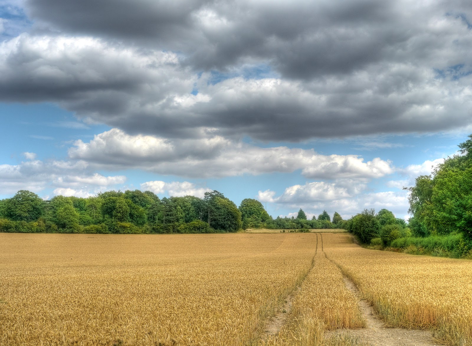
When producing the BRT trace a few of the byways were not shown on the OSM map so I used the Hybrid view showing the Satellite view and I traced the track I took. The route heads out towards Great Wilbraham and then takes Mill Road which seems to be a rat-run road to the A11 dual-carriageway. It does go over the A11 though and on towards a Quarry. The bridge over the A11 is single-track and light-controlled and you do get some big lorries heading towards the quarry. There was nothing around when I cycled along it and the Traffic light sensors switched the lights before I got to them. The quarry looks a bit intimidating, there is a sign showing the byway in one direction and the bridleway in the other, you take the first left after the right turn, with Quarry on either side - the byway climbs from around 30m to 70m.


KirtlingAnnotated.jpg


This is the view from the top of the hill - well near the top of the hill - around here there are a few pine trees along the hedgerows and it looks a bit like Breckland. Although the weather forecast hinted that there might be the odd shower and the clouds looked dull I wasn't convinced. I did wear my fluorescent yellow jacket just in case.


P1150455_56_57_58_59_60_61_tonemapped.jpg


I had intended to cross the Six Mile Bottom Road and use a "yellow" road instead - but I forgot and climbed up the hill towards West Wratting before turning off towards Weston Green crossing the Ford and heading along byways to Carlton. (I'd come this way in reverse the last time.) The byway wiggles a little bit before heading to Carlton This is the final leg of the "Carlton" byway - it is a pretty reasonable track - flat and not too soft.


P1150475_69_70_71_72_73_74_tonemapped.jpg


After emerging onto roads next to Carlton church I thought I knew where I was going and took the wrong turn. After a few kilometres I looked at my GPS and wondered why I seemed to be heading in the wrong direction! If I had printed out a bit more of the map of the area I could have looped back around - but I hadn't so I turned round back to Carlton and took the right road to Great Bradley. Just as you enter the village there is a left turn along a no-through road - Water Lane. If you follow the link you will see that Google have blurred the road sign or at least the "Water" bit of "Water Lane". Google in their thoroughness have even taken their Streetview camera along Water Lane at least until the Ford. Being an intrepid cyclist I braved the rushing torrent of water and cycled through the Ford. Actually the raging torrent was more like a trickle as you can see in this picture, which looks back towards Water Lane.


P1150482_76_77_78_79_80_81_tonemapped.jpg


The route becomes a track and despite the dry spell we have been having there were one or two quite large muddy puddles along the way. There was a water course alongside the track with what looked like Weirs. It turns out that this is part of a Water Transfer Scheme - The Ely Ouse-Essex Water Scheme - completed in 1972 it diverts water from entering the Wash and out to sea up near Kings Lynn using pipes, pumps and this "Stream" Kirtling Brook. According to the link 400 million litres per day are pumped from Kirtling. This is set to change in 2014 when a pipeline will either augment or replace Kirtling Book as the conduit for the water. The reason is that they want to increase water flow to an expanded reservoir, but without causing environmental damage by having torrents of water running down the brook. This is Kirtling Brook looking south.


P1150489_3_4_5_6_7_8_tonemapped.jpg


There are some interesting patches of old woodland around - but trees are dying - I am not sure what the dead tree in the picture is though. The wood is Lopham Wood I think.


P1150503_497_498_499_500_501_502_tonemapped.jpg


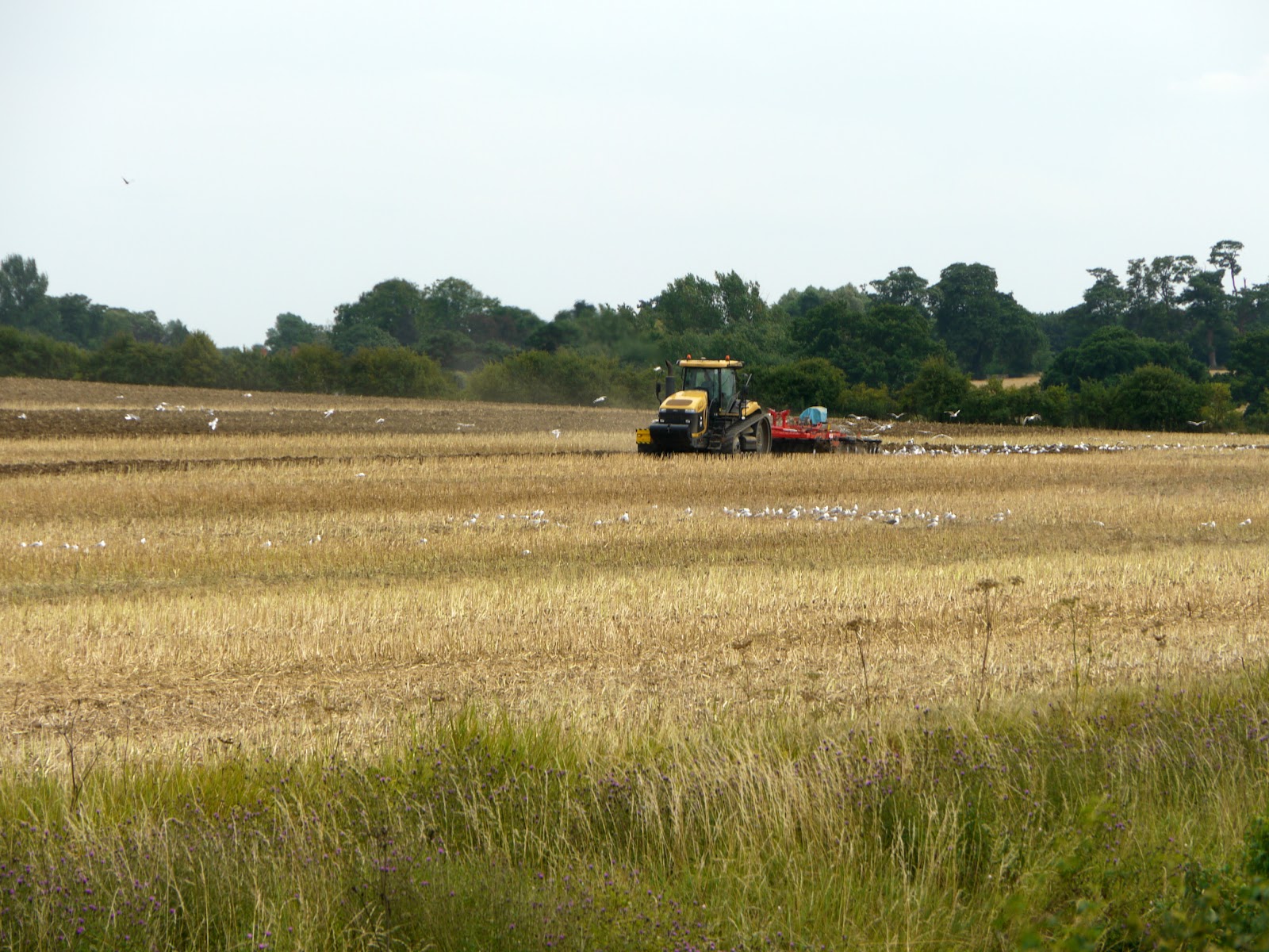
This field on the other side of the track has been combined, cleared and is being ploughed ready for the next crop to be drilled.


P1150504.jpg


As I mentioned above I followed a footpath at the last section of Water Lane but both cross where the track becomes a road again and joins the Woodditton Road at Kirtling. I turned of the road along a Byway as a short-cut through the village. I did stop to take a picture of the Kirtling (and Upend) village Information Board. A map with some pictures of some paw-prints to help identify animals in the area.


P1150505.jpg


My plan was to pick up a bridleway near a wood called Lucy Wood to the North of the village. The bridleway is quite a long one but strangely does not seem to quite reach the road. Instead it ends just short with three footpaths leading off. It always surprises me when a bridleway appears to go nowhere. I would have thought that rights of way came about because they were working routes of old. So when one stops short, especially a long-ish one it makes you wonder. The bridleway seems to be a decent working farm track. Whilst cycling along it I assumed I would carry straight on. Once again I did not bother checking my map. This picture shows the choice - I was a little surprised to see a sign almost overgrown on the verge on the left - "No Horses" Humm, no horses implies that it isn't a bridleway, which means I was taking the wrong route. I carried on for a little bit to find that the track then headed North-East - I was definitely going the wrong way. So I turned back.


Near Kirtling.jpg


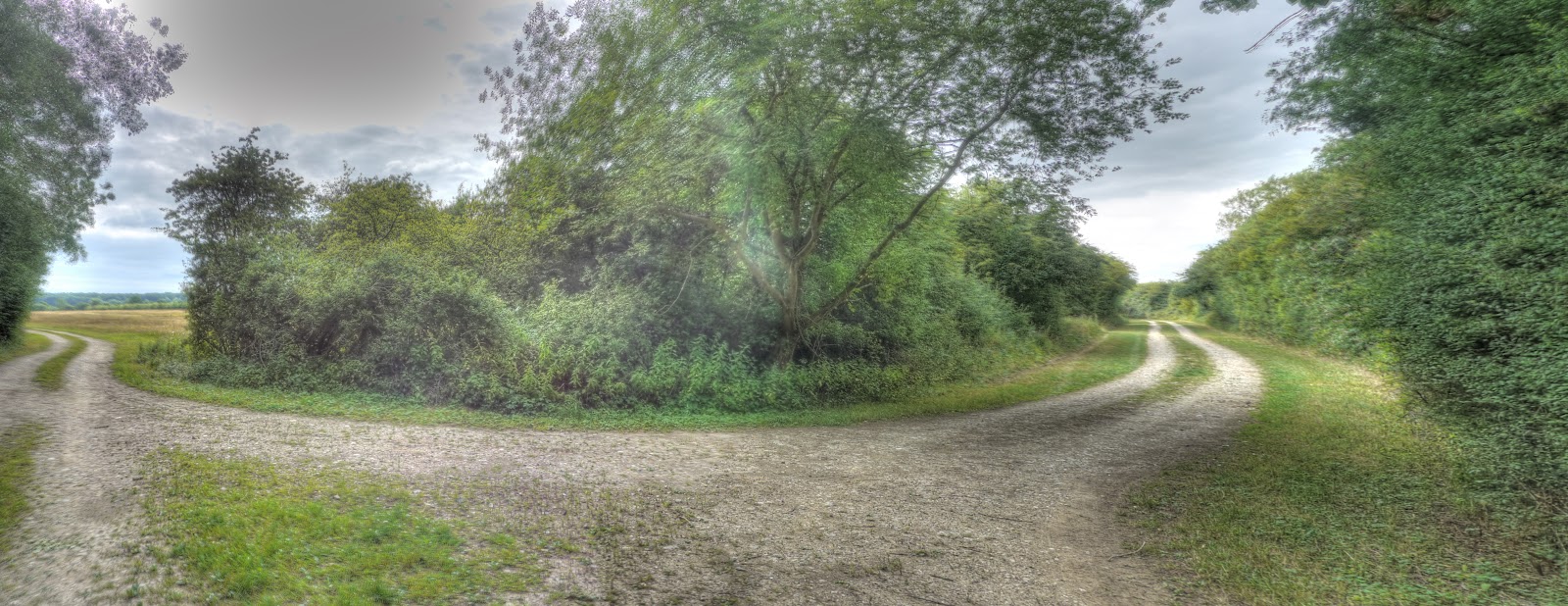
I stopped back at the "junction" and a quick check of the map showed me the error of my ways. The correct way looks more like the bit of track I had come from.


P1150514_08_09_10_11_12_13_tonemapped.jpg


If anything the track got even better. There are Stud Farms around and I assume they help maintain the quality of the bridleway as a route for exercising horses. As I was cycling up the track there were three large deer ahead. They scampered along for a while before turning off through a gap in the hedge where they seemed to disappear!


P1150528_2_3_4_5_6_7_tonemapped.jpg


The bridleway then picked its way through a couple of Stud Farms and the track became a sand track. The going was good though, it was firm sand. There were a few people about riding horses, jogging and dog-walking.


P1150529_30_31_32_33_34_35_tonemapped.jpg


The bridleway became Parsonage Farm lane and I went across a crossroads onto Maypole Lane and then down a track to join a bridleway between Woodditton and Newmarket. This was one of the higher points of the area at 105m, with good views down to the Devil's Ditch.


P1150556_0_1_2_3_4_5_tonemapped.jpg


This is the view of the track made up of three pictures stitched together. The track to the left drops down the hill and then meets the Woodditton to Newmarket bridleway.


Near Kirtling DD2.jpg


Down at the bottom of the track (Dane Bottom) it looked like there was a field of Oil Seed rape just coming into flower.


P1150598_2_3_4_5_6_7_tonemapped.jpg


My route at this point was similar to the last time I cycled this way. I did have a moment when cycling along North Street in Burwell - which is part of Sustrans 51. As is to be expected with small village streets there were cars parked by the roadside. As I was cycling along, my side of the road was clear. There were cars on the other side and as I was halfway past the obstruction a green van coming the other way with two young lads came straight at me. They did not slow down and forced me into the kerb shouting abuse as they went by. It makes me think I should start using a video camera on my handlebars - that form of bullying should lead to a ban from driving. It is basically a form of assault with a deadly weapon - pure and simple.


Wednesday, July 28, 2010

Cycling the mean streets of the inner-Fens

I often talk about my "standard" ride out into the Fens towards and around Wicken Fen - over the time I have been riding out here (in the Flatlands) it has changed and still changes; depending upon my mood, how much time I have, what the weather is like, if I am on my own or not. It was probably kick-started by the work of Sustrans and the National Trust in opening up the Sustrans 11 route through to Ely via Wicken Fen. To be honest I can't remember just when the route opened, but I have found this Press Release - "Burwell Linked to Wicken Fen by New cycle Route" which indicates the Route was officially opened on September 5th 2005. Although there is also a reference to the planning of the route in this Cambridge Cycling Campaign Newsletter 25 - August/September 1999. Clearly a lot of work goes into opening up these routes.


The route of my ride on Monday is available on BikeRouteToaster here it started with a brief off-road excursion around Honey Hill and Snouts Corner before heading up to Horningsea and then heading off-road again towards Lode and White Fen where I bumped into MikeC (not literally) so we chatted whilst heading towards the Reach Lode Bridge with a slight detour around Lord's Ground Drove. I then headed along Straight Drove, through Upware and to Wicken village. I often cycle through the village and then back again, I am not sure quite why, I think it rounded up the distance on one such ride. Sometimes I carry on to Soham, but not usually, in the wet weather the tracks between Wicken and Soham get very muddy though so be warned. Then I head back through Wicken Fen often detouring slightly to CockUp bridge (to take pictures) and then through to Burwell. Here I sometimes then take Sustrans 51 back to Cambridge, other times I ride back through White Fen and Lode, it adds another 4-5Km.


All in all the distance is around 64Km/40miles but very flat, it starts at 7m above sea level, with a maximum elevation of 19m and a minimum elevation of 0m. The only real challenge is if it is windy.


HSea and Wicken Fen Annotated2.jpg


Whilst Cambridge is probably one of the more crime-free places in the UK, apart from bicycle theft that is, we still get crime out here. Cars pollute the countryside not just by being driven but also when stolen cars get torched. Unfortunately some of the tracks and byways seem to be where such anti-social behaviour takes place. Whilst encountering burnt-out cars is not an every day occurrence I do come across a handful of wrecks each year. The local councils are very good at removing them - but that is an activity that costs all tax-payers/rates payers. I am not sure if the police also get involved. There was a burnt-out car on Low Fen Droveway just after the bridge over the A14. This is the point where the road surface changes from tarmac to potholes and gravel. Strangely enough the car was parked to one side, so as not to block the track? In the past earth banks have been used to block the road over the bridge, but they block all access.


P1150299_3_4_5_6_7_8_tonemapped.jpg


It always amazes me just how much of the car gets burnt when it is set on fire - I assume petrol is used to accelerate the fire. Fortunately the field was not also set on fire. I am surprised since it looks pretty dry.


P1150292_86_87_88_89_90_91_tonemapped.jpg


This pea field along the Drove seems to be getting drier and drier, I guess it will only be good for seed now?


P1150313_07_08_09_10_11_12_tonemapped.jpg


The lamp posts to the right of the skyline are at the Quy roundabout over the A14. Sustrans 51 runs close by, but fortunately bypasses the roundabout. The field alongside is being combined.


P1150314.jpg


The shared use path to Horningsea has still not been painted - perhaps there is an official opening in September they are waiting for. The village was apparently the centre of the Roman industry between the 2nd and 4th Centuries. The sign was designed by a schoolboy, Simon Hellowell in 1977 and illustrates the pottery connection.


P1150335_29_30_31_32_33_34_tonemapped.jpg


After the brief bit of road through Horningsea it was back along a bridleway (the Harcamlow Way) - a bit more inner-countryside or rural reality.


P1150342_36_37_38_39_40_41_tonemapped.jpg


A quick stop at Allicky Farm to take a picture of another common countryside sight - a field-side plough.


P1150356_0_1_2_3_4_5_tonemapped.jpg


The worrying thing is that I have been taking pictures of wildflowers on my cycle rides and, in the main, identifying them - but it is not getting any easier. I still find myself scanning my book and several different websites before, hopefully finding a name. This flower looks fairly distinctive - but it still took a while to name - Common Toadflax (Linaria vulgaris). One interesting snippet because the of "closed" flower it requires a strong insect to pollinate it. Like snapdragons, the picked flower can be made to talk by squeezing the sides.


P1150357.jpg


This picture was what helped me to clinch the identification - the yellow downward pointing spike.


P1150364.jpg


Ready for harvest?


P1150373_67_68_69_70_71_72_tonemapped.jpg


Whilst cycling out of Lode towards White Fen, Bottisham Lode looked pretty low - I presume that water is diverted to the more important ditches in the balancing act of keeping the Fens drained but with water for irrigation and navigation.


P1150380_74_75_76_77_78_79_tonemapped.jpg


Approaching White Fen, I bumped into MikeC and we took a more scenic route to the Reach Lode Bridge it was easier to talk as we cycled. Car drivers seem to expect to be able to take up the quite a chunk of the width of the road even if there is just one person in the car - and they certainly expect to be able to chat with their passengers so why do they got so incensed when cyclists ride two abreast?


In fact Rule 66 of the Highway Code indicates you should: never ride more than two abreast, and in single file on narrow or busy roads and around bends - so it is permitted.


I then headed North - but stopped on the concrete bridge over Commissioner's Drain - I could see seven irrigation sprays around me - and it was drizzling. As my wife says if she wants it to rain then all she has do to is water the vegetables. There are three sprays in this picture alone.


Commissioners Drain.jpg


Another three sprays in this picture.


P1150401_395_396_397_398_399_400_tonemapped.jpg


A view of Reach Lode Bridge peeping through the trees - this is also due to be opened in September - that magic month for opening things. Come to think about it - it is not unusual to delay openings and press releases and product launches because August is viewed as the holiday month - you get more attention in September.


P1150402.jpg


Yet another irrigation spray alongside Reach Lode.


P1150403.jpg


More Combining taking place - this was on the Upware Road. When MikeC and I cycled down Lord's Ground Drove we passed some huge pieces of farm machinery that had been "digging" beetroot.


P1150404.jpg


Whilst checking the map to see if this track has a name I did wonder why I cycled along the Stretham Road at all, there is a byway near where the Upware Road joins the Stretham Road and joins Sustrans 11 between Ely and Wicken and would be far more pleasant. This track has no name on the map I am using (Streetmap 25k) and at this point is a byway. There is a view of Ely Cathedral at the bottom of the track. My advice is not to cycle along the left hand "rut"!


P1150413_07_08_09_10_11_12_tonemapped.jpg


Otherwise you might find yourself giving blood. There are a few thin brambles growing out from the hedge and I was not able to avoid all of them. My blood looks rather too red in this picture - more like a red crayon - still it seems to work.


P1150406.jpg


This is the same track, but looking towards the road, where it passes a dilapidated building that seems to owe its design to huts built in the war. (Nissen huts) The use of corrugated asbestos for the roof would no longer be approved though I think. It also looks as if some lazy sod couldn't be bothered taking his/her rubbish to the tip and left it down this track.


P1150420_14_15_16_17_18_19_tonemapped.jpg


I have been along this track quite a few times but only noticed this box on the Public Byway sign for the first time. Why is there a box on the pole and what is the electrical hazard? I would not have thought that the box was placed here for a joke, perhaps the pole was transplanted and came with the box and no-one bothered to remove it. Or maybe the sign is to warn of the pylons on the other side of the track?


P1150421.jpg


On my way back through Wicken I cycled along Back Lane, which runs parallel with the High Street but on the Wicken Fen side. The metallic green colour caught my eye. I understand that planning rules are more relaxed for farmers putting up agricultural buildings - although I have not idea whether this falls into that category.


P1150428_2_3_4_5_6_7_tonemapped.jpg


I had actually stopped to take a picture of this building on the other side of Back Lane.


P1150435_29_30_31_32_33_34_tonemapped.jpg


Rural dwellers have their share of utility problems. Mill Road in Cambridge has problems as the sewers are having to be sorted and the road is closed as a result. Although I guess I could cycle along it and walk past the repairs? However as I know there are problems I avoid it completely and am not sure how long ti will be closed or indeed if it is still closed. Along Factory Road between Wicken Fen and Burwell (part of the Sustrans 11 route) it looks like a Water main is leaking. This had been marked with blue pain on the road, on the nearby telegraph pole and with a stick and some leaves also painted blue. I would imagine that this might cause problems for Priory Farm if it is their supply - there could be quite a loss of pressure.


P1150436.jpg


A brief stop and the Lode Crossroads, progress is being made on the new crossing. I have assumed that it will control both traffic flow and pedestrian cycle flow. Whilst I am not a huge fan of diving if you can cycle it would seem reasonable to make it easier for cars joining from the Lode and Bottisham sides of the crossroads to be able to join the "main" road more easily.


P1150443_37_38_39_40_41_42_tonemapped.jpg


The field near the Quy Mill Hotel alongside Sustrans 51 - it is a field of oil-seed rape being harvested.


P1150271_65_66_67_68_69_70_tonemapped2.jpg


For some reason I had assumed that despite the greyness of the sky it was not going to rain - as it happened I got drizzled on three or four times - but I quickly dried when it stopped so as is often the case it did not worry me at all - although if I had known it might have put me of going for a ride.


Cycling News Snippets

I have got one cycle ride to Post - which I will get around to - I have downloaded the pictures into a draft Post and just need to write a few words around them. Before that though, I thought I would do a quick round up of various cycling snippets that seem to be hanging around on my Browser window. The London to Cambridge cycle ride has had a couple of pieces in the Cambridge News: "Cyclists' 60-mile funds push" and "Cathy, 71, does London to Cambridge - with new hip". As Tom mentioned in his comment, about 4,500 people took part with a target of £2m for the charity Breakthrough Breast cancer. And, as the second link demonstrates one entrant did not let the matter of a hip replacement 18months ago put her off - That shows both determination and the wonders of modern medicine.


The Cambridge Guided Busway (CGB) is seldom out of the news long - Cambridge MP Julian Huppert has branded it a "white elephant" - which at the moment is difficult to argue against - it costs a fortune and provides little benefit. Although I should point out that cyclists, horse-riders and walkers have been enjoying using the new route. The comments are part of a debate he is leading in Westminster on a strategy for solving the city's transport problems. He is reported to be in favour of sustainable approaches and the need to redirect the mind-blowing £1.3bn A14 upgrade into public transport, walking and cycling.


Whilst I am sure that not all of the CGB problems are of the County Council's making one failure to deliver the scheme does not help their credibility. It also turns out that a "Quarter of parking fines in the city are left unpaid" in Cambridge. It would seem that 11,000 are unpaid which amounts to over £0.5m - although I am not totally clear just how many were cancelled. It is easy to criticise without the facts, however this does seem to be a very high percentage of unpaid fines.


There seem to be quite a few reports criticising Speed cameras as a tax on car drivers and that they should only be deployed where there is some history of accidents. However this seems to ignore the problem of fast roads driving away other road users/pedestrians because of speeding cars not to mention how noisy speeding vehicles are. However here in Cambridge there were public calls for speed cameras on a riverside road between Ramsey and Chatteris. In my experience fen roads are often straight, but they can suffer from undulations as the fenland soil shrinks. They are also often alongside ditches/drains and so speeding cars can easily get into trouble and end up in the water.


Since I tend to note incidents where cyclists have been involved in hit and run accidents where the driver does a "runner" it does happen the other way around sometimes. In a recent incident where a cyclist badly injured a pedestrian on Jesus Green that cyclists has been charged with amongst other things grievous bodily harm and handling stolen goods. So at least they have caught the cyclist. I wonder how many of the hit and run drivers are caught and charged?


I have mentioned the problems facing conker trees (Horse Chestnut trees) well the problems have made the local news as well: "Canker, blight and moths kill our trees". Apparently Oaks, pines and larches are also at risk - the countryside of my youth is in for drastic change it seems.


Sunday, July 25, 2010

Cambridge to Carlton and back - but in a loop

This is one of those lazy summer day cycle jaunts - I was not in a hurry, I was not bothered about exploring, but I did want to get away from busy roads. So I set off with a rough direction in mind and a map - yes a real paper map. My tatty Cambridge & Newmarket OS 1:50K map, with a 1981 copyright, was a little out of date but I wanted something that gave me a better perspective on where I was relative to the surrounding countryside. The map on my GPS is ok - but it has a small screen and when zoomed out hides a lot of detail which makes it less good for generally cycling along in a rough direction. The out of date OS map could bring some context to where I was and what roads/tracks would be appropriate for heading in a general direction. My starting point for a direction was to head out of Great Wilbraham along a byway to the North-East and then pick up another byway towards Westley Waterless.


This is the route I eventually followed - shown below and is available at this BikeRouteToasterLink. The route meandered a bit and according to the summary information on BRT is just over 73Km in length with 279m of climbing and reaches the dizzy heights of 117m above sea level. It was quite sunny so I took some sunscreen with me, just in case I started to go red. Mind you my arms and legs are sufficiently brown now that unless there is direct midday sun I don't bother putting on sunscreen unless I am planning on a day ride. However I do take the sunscreen just in case and have had to use it on one or two occasions mid-ride.


OSM loop via Weston Colville NMKt Exning.JPG


After cycling out of Great Wilbraham this is the byway, not a soul in sight, a firm track and a blue sky what could be better than that for an afternoon's ride. The camera does make it seem longer than it is - there is a dip and then a road to cross - actually it is quite an unpleasant road to cross - it is a country lane (Wilbraham Road) and straight with some slight bends with adverse cambers and in my experience cars whizz along. So you have to stop and look before crossing the road onto the byway the other side. On the 1930s OS map the byway was called Streetway.


P1150206_0_1_2_3_4_5_tonemapped.jpg


The route then joins the Heath Road byway. This used to be a crossroads of byways according to the 1930s map, but when the A11 was built (or perhaps when it was turned into a dual carriageway) there would have had to have been two byway bridges built close to each other to accommodate the two byways. Consequently they diverted one byway and created an alternate route alongside the right hand side of the A11. The Heath Road continues over the A11 and crosses the A1304 before a gravel track where it crosses the Cambridge to Ipswich Railway Line. The crossing is not controlled you check some lights and then push through a gate for those crossing on foot on either side. The track then becomes a country road and climbs up hill.


The hill is called Cambridge Hill and here it is in this, the road is the other side of the hedge on the right of the picture. At this time of year, especially with all the dry weather, the fields all look brown with the odd green strip from hedgerows or clumps of trees.


P1150220_14_15_16_17_18_19_tonemapped.jpg


After reaching the top of the hill instead of cycling to Westley Waterless I headed right and then took the Icknield Way Trail to the East, where it met the B1052 but I turned off after a brief spell on the road and headed along another byway - Brook Lane. This byway started off as a gravel "road" heading down hill - not too bad but some care was required with the lumpier stones and the odd stick on the path. Looking at the map there are a few byways/bridleways that lead off this path that would be worth exploring another time.


Somewhere on along the byway I took this picture. I can see from my GPS trace the point where I stopped to take the picture, but when I look at the same place on either the OS map or using Google Earth I can't see the house nestling amongst the trees. Never mind - I took the picture of the Combine Harvester and the neat stripes left behind. Because the Combine was moving this is a single exposure picture - but with a bit of Photoshop Elements tweaking to make the clouds in the sky look a little more visible.


P1150221 PSded.jpg


The same view - but this time using an HDR multiple exposure and without the Combine Harvester in the shot as it would have moved between the 7 different exposures and so appeared as a blurred mess.


P1150228_2_3_4_5_6_7_tonemapped.jpg


The byway ended up at Weston Green. This byway connects to the road via a Ford, however despite my recent experience of cycling along the slightly flooded CGB I decided to use the bridge alongside. It seems that quite a few byways in the Flatlands have an access restriction of some type. In the picture you can see open gates and the back of a sign. I believe this Byway is closed from 1st October to the 30th April with the exception of Pedestrians, equestrians, pedal cycle-arians and permit holders. The County Council keep a list of them here, which might be worth checking for interesting routes.


P1150237_1_2_3_4_5_6_tonemapped.jpg


The byway seems to go through an area called Three Horseshoes and after the Ford leads onto a short road - Horseshoe Lane, where short means less than 200m long. On the one side is a recreation area with playground and cricket nets and on the other side are houses. so why does it have a 40MPH speed limit. I would have thought this was a street more suited to a 20MPH limit with kids playing in it.


P1150238.jpg


I then cycled along various roads including Common Road though Carlton and then to Burrough Green which seems to have loads of footpaths but only to byways. I have cycled on both byways in the past this time I went North past Gipsy Hall through Dullingham Ley and then up another byway to Woodditton. Whilst just checking my route on the map I noticed that there there is a route from Great Bradley through to the Woodditton Road called the Stour Valley Path which is shown with green dots (on the 25K map) and so cycle-able with another track through Kirtling to Little Ditton. So even though I did not really cycle on new tracks this times around it has thrown up some interesting possibilities for a future ride.


Back to this route - the Water Tower at Woodditton is a useful landmark, shown here and marks the byway which runs almost parallel with the Devil's Ditch which is a footpath and so not cycle-able.


P1150244_45_46_47_48_49_50_tonemapped.jpg


The byway skirts around Camois Hall with a few horses in the fields and and follows a farm track past a strip of trees. The track is pretty good for a hybrid bike. To the left of the picture is a strip of green that is the route of the Devil's Ditch. The valley in the middle is Dane bottom with a footpath connecting this byway with the Devil's Ditch. There were a couple of hikers on the footpath heading towards the "ditch".


P1150257_1_2_3_4_5_6_tonemapped.jpg


The bridleway crosses a road before emerging on the B1061 next to a pumping station. This was the most unpleasant road of the route. A large Mercedes estate whizzed by rather too close for my comfort and it was surprisingly loud. I guess that luxury cars are assumed to be quite because they are quiet when sitting in them because of all of the sound-proofing. You'd be surprised (well the driver and passengers would be) at how noisy they are roaring along at 60MPH ON THE ROAD. In Newmarket In Newmarket the Taxis are distinctively painted in yellow and black. One passed me much closer than the Merc driver, it was if he had not seen me! If I had not been so shocked I would have taken his number and complained - but it was so close I stopped.


Newmarket itself is on the route of Sustrans 51, but I passed through and on to Exning where I used the byways (Haycroft Lane and Howlem Balk) to get to Burwell. This is Haycroft lane - it is pretty overgrown at the moment - you can't really see the track for long grass - it is a nice route though and I almost never see anyone on the track.


P1150264_58_59_60_61_62_63_tonemapped.jpg


I almost forgot to mention that I almost succumbed to one of the problems of cycling in the Summer. I swallowed a fly - or rather a fly went in but lodged somewhere halfway down my throat - I wasn't sure whether to swallow it or spit it out. Neither tactic worked at first - I had to stop in order to be able to properly "hawk" it up.


The route was a pleasant one and easy to cycle in fine weather - bits of it can be a challenge (for me anyway) on a hybrid bike.