
Tuesday, 5th October: Although I keep on about the weather becoming Autumnal (Fall-like) all I can really say is that it is quite changeable and although leaves on a few of the smaller trees seem to have started changing most trees have not changed. We have had a bit more rain and wind recently but the temperature has been reasonably warm. I am still wearing shorts to cycle and when not in formal meetings the rest of the time as well. I wanted to fit in a bit of cycling with time from the "I don't waste time commuting to work" bank - but where to go? It was a grey day, I have been up the CGB recently and don't expect the flooding has been miraculously fixed on the cycle path near St Ives. With all the rain I did not really want to cycle along gloopy byways, where to go?
So by default I headed out along NCN51 towards Wicken Fen, but my heart wasn't really in it. I was enjoying the cycling, but sometimes you need a change of scenery! So instead of following NCN51 into Bottisham I carried on a bit further and turned right along the Wilbraham Road just past the River Farm Smokery. Although it sounds like a picturesque farm on a river in fact the buildings are remnants of RAF Bottisham which used to be a World War II airfield. (Top right in the photograph in the link.) The food does get featured on the menus of local pubs though. Once there I decided to head for the byways near Wandlebury - I figured they would probably be ok as they are not heavily used by farm vehicles or walkers and seem reasonably well drained.
Here is the route I followed in the end (and on this BRT link) it meanders round a bit especially at the end of the Southern Section of the Cambridge Guided Busway (CGB) and I would not recommend taking the route I did out of Sawston - I was trying a road I had not been along before (by any mode of transport). The route is around 50Km/ 30 miles in length with one or two unpleasant stretches of fast main road. This ride also scales the dizzy heights - well it reaches a maximum elevation of 48m above sea level.

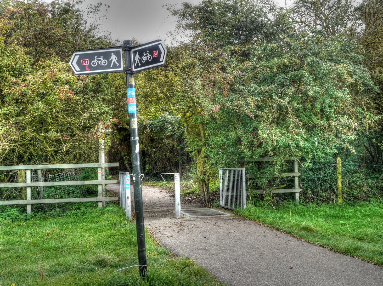
Mind you at the very start of my ride as I cycled through Ditton Meadows I had to stop to take this picture. MikeC mentioned the Missing Sock in a recent comment. It is a restaurant along the NCN51 between Stow cum Quy and Bottisham and was previously known as the Prince Albert. Well good news - I have found the missing sock - see it is there on the NCN51 sign just below the "51"
It was a grey day and there was not much to stop and take pictures of - but on the way out of Great Wilbraham, on Station Road, this sight stopped me in my tracks. The hedgerow had been flailed - I am not convinced this is the best way to cut a hedge as the damage seems to linger and rips the hedge apart. However a look on the web throws up loads of information indicating it is not a simple issue.

I cut through Fulbourn onto the no-through-road - the Babraham Road which leads to the Roman Road between Cambridge and Balsham and is called Worsted Street ( the page opened has a very dated feel to it by the way.) I was not on Worsted Street long before turning onto Mile Road another byway leading off to the A1307. This is Mile Road as you can see my guess about the surface being Ok, even though we have had quite a lot of rain was right. You can also see that the majority of the leaves on the trees are still green.

Before heading up Mile Road I took pictures looking East along Worsted Street - this track was also in good shape for cycling (and walking).

Worsted Street looking West towards Cambridge. You can see that the Beech leaves seem to have a pre-Autumn tinge to them. If you follow the Mile Road link above you will see there is a Long Barrow alongside Mile Road that I missed - must look out for it next time.

Whilst cycling along Mile Road I did take a picture looking towards the woodland in the Wandlebury Ring direction - Wormwood Hill. There is another byway running parallel to Mile Road between the woodland in the picture and Wandlebury behind it. Apparently a crop circle was "found" near (ish) here in July 2001. The wood in the picture seems to be called Fox's Burrow.

A bit further along Mile Road a tree that is "turning" yellow. The path was in good condition all the way to the main road. Although the gap as it passes through some houses, just before the road seems to have been narrowed somewhat.

I cycled along the A1303, it is a most unpleasant road fortunately you don't have to go too far along it. I did have a double decker bus pass close by me though - there was a hell of a suction" as it whizzed past. Now I don't want to worry you but look at item D in the link, the effect is worse with a cross-wind. "Suction" also gets a mention in Cyclecraft, page 7 of the pdf.
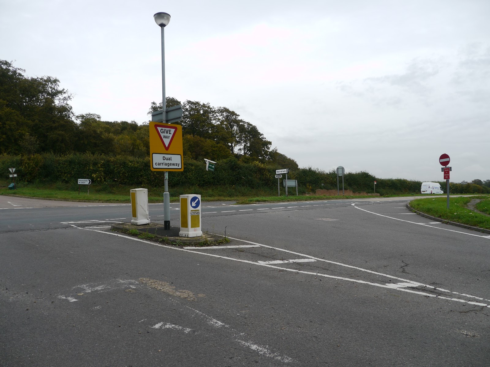
This is where I turned off the A1303 towards Babraham, the road opposite leads to Worsted Lodge where you can join the Worsted Road (Roman Road). If you look closely on the small sign post in the middle of the main road (not the Give Way sign post) beneath the sign pointing to Babraham is are signs pointing out a Cycle Ride. These seem to be remnants of a previous generation of council or are are they from another secretive organisation set up to create cycle routes - but not to tell you where they are. There are a few of these around and about I guess they were put there by the County Council - but time has moved on. On the way down Babraham Road there is another one pointing towards Sawston.
In fact it pointed along this road - soon to benefit from the development of the Sawston to Abington cycleway. (The same information in high contrast! I now get the point of the other high-contrast CCC webpage.). This Press Release shows where some of the credit is due. In fact the link also gets a mention on the Sawston Wiki page. It looks good so far - and when they connect it through to the footbridge of over the A11 will open up a pleasant route out of Cambridge including to the Granta Business Park.
A piece of trivia - when working for an R&D group, the Welding Institute, Abington was where I presented my first paper to an audience outside of the company I worked for. My boss's boss was driving us and we were late. So when we got there I walked into the projection booth handed my slides to the guy running the projector (pre- laptop days - we used 35mm slides) and as I walked through the back door into the Lecture Theatre I heard my name being announced. So I carried on walking to the front, took the control to advance the slide projector, said good morning, crossed my fingers, plipped the slide controller - and there was my first slide. In hindsight it probably helped me as I had no time to sit in the audience worrying whilst waiting for my turn.

My route out of Sawston took me past the college and onto the A1301 - it looked as if I was going to be able to cross over and find a quiet route out - but it turned out to be a company site - Spicers paper Mill. So I had to cycle back up the A1303 to join NCN11 on the outskirts of Sawston. There does appear to be an opening up of a new route from Great Shelford to Whittlesford - so I could probably have done an advance "recce". Some of these new routes outside of Cambridge are quite difficult to find information on, although if you go to Sustrans mapping site and look for Sawston you can see where the route is planned to go. (Here is a schedule of works for the South Division of Cambridgeshire. (Actually the Cambridge Cycling Campaign has some good info - I should have realised they would.) Once on NCN11 I carried on along the Human Genome. as you can see it runs alongside the railway line into Cambridge from London.
I thought I had taken pictures both ways - but in fact both look the same way, this one is at a higher zoom factor. This path has also got lights alongside to make it easier to use at night.

After the rather pleasant Addenbrookes Great Shelford Cycleway I followed NCN11 before turning off along the Addenbrooke's-Trumpington cycle-path (unsurfaced) (I used the " ' " on the map - inconsistently used on the two paths.) I got to cross the railway line without the benefit of any lights and then pottered around a bit taking pictures of the CGB. This is the single running section looking North from the A1301 ex-railway bridge.

This view looks South from the same bridge. There is still quite a bit of work to be done by the looks of things.

This is the final tunnel bridge before the CGB reaches the Trumpington Park & Ride site.

I then meandered around a bit. I headed of to Grantchester and then for the first time in ages cycled along the Grantchester Meadows Cycleway - a very pleasant tarmac path along the course of the River Cam. It seems to be quite popular with both dog walkers and runners so don't expect to zoom along it at busy times.
After that came Grange Road, not the most pleasant of parts of the route - the cycle lanes there are rather thin and there are traffic islands for traffic calming and bits of the road has been re-surfaced but not the cycle lanes. In my experience with such narrow cycle lanes when you reaches a traffic island the effect is to create a pinch point and cars try to zoom past cyclists and then brake whilst pulling to the left to give cars coming the other way room. It can be disconcerting.
Around Gilbert Road there were 13 cars in the cycle lanes - I make sure I indicate well ahead and pull out well into the middle of the lane so that I don't get doored. That way you also get respect from cars/vans following who have to slow down. To be fair I have never had any issue with impatience behind me - but I do give some grand-gesture type signals and there has been publicity in the press about the road. Mind you the Cambridge Cyclists recent experience of Road Rage on the Oakington Airfield road does indicate the dangers of road rage.
I also passed along this popular stretch of the River Cam - featuring in the Cambridge News piece on Loophole in Mooring Fees. This bit did not look too bad to me.

And finally a fly-tipper has been caught, he dumped rubbish on Pauley's Drove in Rampton, between Cuckoo Lane and the High Street. Part of the route from Histon to the Aldreth Causeway that I take when wanting to stay off-road as much as possible.
what camera are you using to talk these photos with, they look really good.
ReplyDeleteThank you.
DeleteIt is a Panasonic GH1 with a 14 - 140mm lens.
I also tend to take "HDR" pictures. My camera takes up to 7 pictures with different exposures and then I use some software called Photomatix to recombine them.
Nice set of nature photos! I have future plan of traveling this area during holiday! thanks.
ReplyDelete