
I've been wanting to cycle out along the Sustrans Route 51 to St Ives and then return via the Cambridge Guided Busway (CGB) route to compare them for some time - well since around Christmas anyway. I finally got around to it on Saturday and I resolved to attempt to stick with the paths alongside the CGB and not to have to resort to cycling along the actual concrete tracks intended for the buses. When I went over Christmas the area around the Fen Drayton lakes, near St Ives suffered from flooding and ice so it seemed prudent to resort to the concrete tracks. However when the CGB is in action that will no longer be an option.
I should probably have given a bit more thought to the recent weather though. Given the over Christmas the CGB cycle/bridleway was flooded and frozen and that we have had more rain recently it was not likely to be any better, apart from the ice having melted. As I cycled through Ditton Meadows it was clear that the water levels were higher than over Christmas. The meadows themselves were flooding.

It became apparent that water levels were high when I arrived at Victoria bridge - there is a path underneath the bridge alongside the Cam connecting Midsummer Common and Jesus Green - the path was flooded - but I had set out to try and cycle the CGB on the paths, so I though I can't give in here and so cycled through the floodwater. Fortunately the water was clear enough and not too deep so I was able to avoid any rocks/branches on the flooded path.

Sustrans Route 51 passes through a village called Girton, separated from Cambridge by the A14. The recent weather has taken its toll on the roads and I have seen lots of potholes - I have not stopped to take pictures of them all - it would take too long, but I did take a picture of this one next to Church Lane. The local council has a facility to report potholes - here. The last time I reported a pothole there was a map facility- this form is text based. One peculiarity is that it requires the person reporting the problem to make an assessment of the danger. The form allows you to classify it as a non-dangerous pothole. If it is dangerous then you are asked to report it via a different mechanism or direct to the police. They do not however provide a link to report a more serious problem!

The Sustrans 51 Route is quite pleasant, along a variety of country roads, but follows a meandering route. I had to stop to take a picture of this signed Public Footpath to Swavesey - is it just me or is the sign warning that there is a bull in the field just a little intimidating. Mind you I could not see any sign of a bull! So perhaps the sign was Bull!

The view across the fields from the previous picture is of the Tripod and Windmill that are on the path of the CGB - old and modern technology side by side.

Although the route meanders all of it lies on either tarmac roads or tarmac shared pavements and I reached St Ives quite quickly - no sign of the man with seven wives though - must be the other St Ives he was leaving. As I joined the CGB route it was clear that the path alongside the concrete tracks was still as flooded as ever. Here is a picture of the first flooded path I encountered - it looks more like a river than a path. I cycled into the water, in a low gear and mindful that the path surface under the water might be pretty chewed up. Within a few metres I found my feet going underwater! Rather than try and turn around and cycle out I jumped onto the banking and hauled my bike up onto the concrete tracks where I then took this picture. It took me a while to realise that my feet were not too cold despite having been submerged under the water - then I twigged - I had a pair of waterproof Sealskinz socks on - phew I was not facing a 20mile/32Km ride with freezing wet feet.
There was no way to cycle along the path so I had to use the track - judging by the mud on this bit of the track a quite a few people had also had the same problem. As I was taking this picture an older lady cycled past bemoaning the state of the bridleway.

Looking back at one of the bits of flooded path it is a shame that a raised walkway/cycleway was not build at least for emergency use. This water was too deep for horses as I saw some riders also up on the concrete track.

Mind you it seems as if there is very little to do - in most places there is no evidence of work still to be done - as I've mentioned before this part of the CGB will provide very pleasant views for those using the buses.

One of the Fen Drayton lakes as the sun starts setting.

Evidence of the CGB's previous role as a railway line - left remnants of a station platform. The traffic lights are where Station Road crosses the CGB.

I did not even attempt to cycle through this bit of flooding - once bitten twice shy! Judging from the banking the design did take into account the possibility of flooding - but not quite effectively as it might.

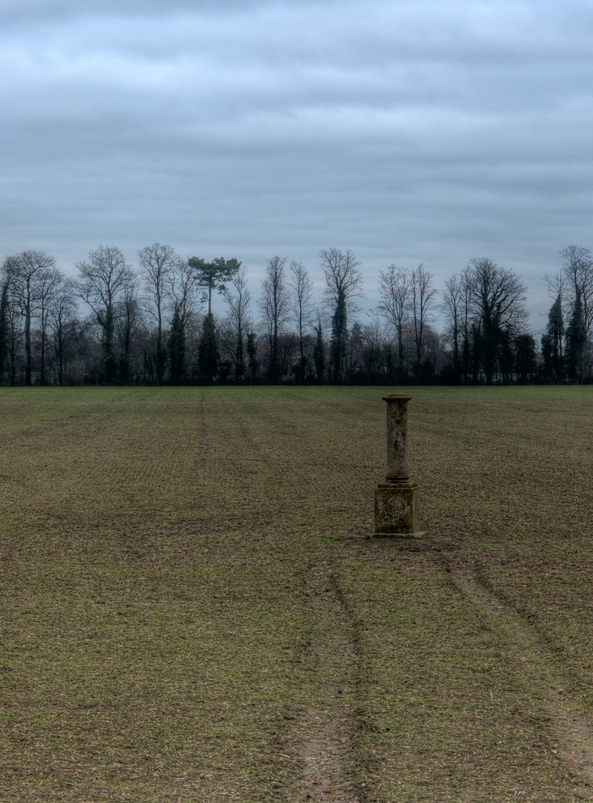
Between Histon and Cambridge there is a small monument in a field alongside the CGB - a quick web-search has not thrown up what it might be - clearly the farmer avoids it - so it must have some importance. I did find this piece and this piece on the History of the Chivers Jam making in Histon though. I did not give up though and one of the Cambridge County Councils map portals referred to the stone as a Memorial Stone. The same website that has a history of Chivers also has a page on the Memorial Stone, a memorial to Mrs Elizabeth Woodcock who on Saturday the 2nd February 1799 was on her way back from Cambridge Market and was thrown from her horse - she was trapped by snow and eventually rescued 8 days later - but succumbed shortly afterwards - apparently brandy was involved in the original accident.
On my way round I got to thinking about shared-use paths and how to let others know I am around. On the way out to St Ives I came across two young ladies riding horses on the road. Apparently it can scare the horses if they do not hear you coming and then suddenly you come into view. I have asked some horse-riders what the preferred way to deal with the situation is. The consensus is a gentle ding on the bell (my bell gives a ding - if you want more you keep pinging it!) - it certainly worked for these two - no scared horses and two lovely smiles - it made my day! Later on, on the CGB I came up on two ladies and their dogs - one ding nothing several dings and they froze across the width of the track and then separated leaving a small gap in the middle with their dogs snapping as I went past. It does seem to me that road-users respond thoughtfully - whether they are cars, cyclists or horse-riders - people walking tend to freeze and block the path when a cyclist comes up from behind. Next time I will be a little bit more persistent with the bell - quietly at first and then more loudly. Mind you also on the same ride one group I passed though my bell was something else.
Mind you it seems to me that most road users think in a car-centric way. I came across a van that had parked right on the shared use pedestrian/cycle way leaving a small gap. With a bike I was forced onto the grass on the side of the path and almost fell off as there was also a gravel trap which grabbed at my front wheel - perhaps all the riding in snow has prepared me for such problems. Anyone with problems walking, pushing a pram or shopping trolley would have been similarly inconvenienced. Why was he - yes a he, parked on the path - because he was on his phone. I was passed earlier one by a car that seemed to pass me quite closely and "wibble" as it went by. This time it was a lady driver - on the phone. She carried on her conversation even when parking at a shop, which she overshot and then reversed to park closer to it - but at least a metre away from the kerb.
Finally a sign warning of roadworks - a pity that it was stuck on a shared use pavement - where there aren't street lights - cyclists should use lights but what about pedestrians using the path.

This is a view of my route on Google Earth. the red trace is the route - the yellow and blue are my comments. You can see how the Sustrans 51 route out meanders somewhat.

I wonder when it will be ready - the CGB that is - it certainly looks pretty complete, I hope they sort out the flooding for all the users of the bridleway. It has been flooded for around a month so far- a large chunk of time.
No comments:
Post a Comment