
One of the problems with having a bit of time off from cycling is that you feel a few more aches and pains or maybe that comes with getting a little bit older? I am not complaining really and they are only slight niggles. It looks as if the weather here in the flatlands is set to be a little more unsettled - mind you the lawn needs a bit of rain. Even with the rain we have had the ground just seems to have soaked it all up.
As August will be a bit light in terms of kilometres cycled and because I did not get out on my bike yesterday I went for ride out to St Ives and back. The routes I take when out cycling can make a big difference to the distance and speed I cycle at. I can see why it is not unusual for cycling groups to hold Time Trials on dual-carriageways and A roads. The better and smoother road surfaces along with the relatively straight route (with priority over side roads) can make it much easier to get into a cycling rhythm and so cycle faster.
The Cambridge Guided Busway (CGB) cycle path whilst not smooth is at least fairly straight with a small number of junctions across it, so for me it is a good route to choose if I want to cover a bit of distance. It is also peaceful, is it just me or are cars and trucks noisier nowadays. I know I keep on about it but I think that the tyres emit a higher pitch of noise which can be really quite unpleasant at even moderate speeds. I wonder how noisy the buses will be running on the CGB? I have been on a bus on the CGB last year when they were running buses for locals to try it out. The bus was very noisy inside so I am not sure quite what they will sound like to cyclists and pedestrians on the path alongside. Occasionally when I look at a Maplin catalogue (a UK company selling all manner of electrical and electronic gadgetry and componentry) I think about buying a Sound Level Meter. The link points to one they sell for £19.99 - although apart from a fleeting bit of early use I am not sure quite what else I would do with it. According to this website city traffic has a noise level of around 85db, inside the car and sustained levels at 90-95db can cause hearing loss. The louder the sound the shorter the amount of time before damage can occur. According to a Wikipedia article on Sound Pressure traffic at 10m is 80-90db and a passenger car at 10m emits between 60-80db and the same article indicates that hearing damage can occur with long-term (but not necessarily continuous) exposure to levels over 85db.
So according to the information cycling along a busy road will subject a cyclist to levels of noise that, if over a long period, can cause hearing damage. Humm - you don't get warned about that when you are told not to listen to your MP3 player whilst cycling. Yet - providing the volume level on the MP3 player is not too great you are probably helping to reduce the damage to you hearing from the traffic. You are often much closer than 10m as a cyclist, in fact closer than pedestrians as well.
After that digression: one of the other reasons for cycling along the CGB "high-quality" path was to check out what progress has been made since last month. There has not been much about it in the press recently. Companies do not put out many press releases during August in Europe - too many people are on holiday - I guess the Cambridgeshire County Council is following suit and not putting out news or there is none. My standard route is to head out on Sustrans route 51 and then back along the CGB. However there are variations on the route - in fact looking at the map I can avoid Swavesey by cycling along a bridleway and then Boxworth End - not that Swavesey is bad - just for a change. This time around I detoured through the Fen Drayton Nature Reserve.
The route as marked (BRT link) is just over 50Km with 70m of ascent/descent.

I was not planning on taking too many pictures - but this car parked over the Girton/Oakington shared-use cycle path annoyed me enough to stop and take a picture. Clearly the driver does not give a toss about pedestrians and cyclists as long as they can keep their car off the road. (Why should just pedestrians and cyclists enjoy the safety of the pavement - what about tin cans!) The problem was compounded by the rubbish bin which was there quite legitimately but increased the chicane effect from the car's door mirror. The other thing you have to be careful about when on a bike is the concrete edge between the path and the grass - it is remarkably easy for a small edge in the direction of travel to catch the front wheel and throw you off the bike especially when your attention is on navigating the obstacle. (yes I have fallen off my bike twice because of such "edges"). Once on a kerb that was slightly larger than I realised and once on a country lane where the road edge was a bit chewed up and a strong gust of wind caught me unawares. This sounds like the ideal area for a bit of activism - a sticky leaflet on the side window asking the driver to respect more vulnerable users perhaps?

It is not uncommon to see the Cambridgeshire Police helicopter in the air, just recently they caught some suspected thieves who were trying to evade arrest by hiding in a hedgerow. When I mentioned it in a recent blog post I had to use a random picture of a helicopter as I did not have one of my own and I try to limit my use of pictures in my blog to those where either they are my pictures or they are freely available. Well as I was cycling towards Swavesey I saw the Police Helicopter in the air and thought I would take the opportunity to get a picture for my "files" to use when and if I were to mention it again. It was most probably having a look at a Camp set up for a Religious Festival for travellers near Swavesey, which seems to have caused some upset.
I took several pictures of the helicopter as it was moving around - I wanted to be sure of getting something half-decent. I had to take the picture on maximum zoom and wanted to get a side-on view. This is the picture, which I enlarged a bit as well. If you look closely you can see that the pilot and observer both seem to be looking at me. In fact the helicopter did pay me a bit of attention - wondering what I was doing perhaps. Although they must be used to people taking pictures - the colour scheme is fairly striking and the call sign - G-CMBS was chosen to reflect its roll as the CaMBS Police helicopter.

After the stop to take pictures of the helicopter I cycled on into Swavesey - where as I was cycling along the main street there was a police car was coming the other way. At that point I would have given the odds as 50/50 that I was going to be stopped and asked about my photography - but I was just being paranoid. I assume that the Police were maintaining a presence in the area to reassure the locals. I was pleased to be going through the village though as I was feeling slightly weak - so I stopped at one of the shops and bought some jelly-babies and some apple juice for energy.
I then headed out of Swavesey and into the Fen Drayton RSPB reserve. There is a speed limit but I was passed by a car going faster along the private road. There are quite severe speed bumps there - even on a bicycle you have to slow down quite considerably. This view is looking into the Reserve from near the Swavesey Road. The plantation to the left of the road intrigues me - I am not sure quite what the plants are - the bushes are several metres tall - almost like sugar cane.

I have taken a picture of this old windmill a few times - it is now a Kennels and Cattery.

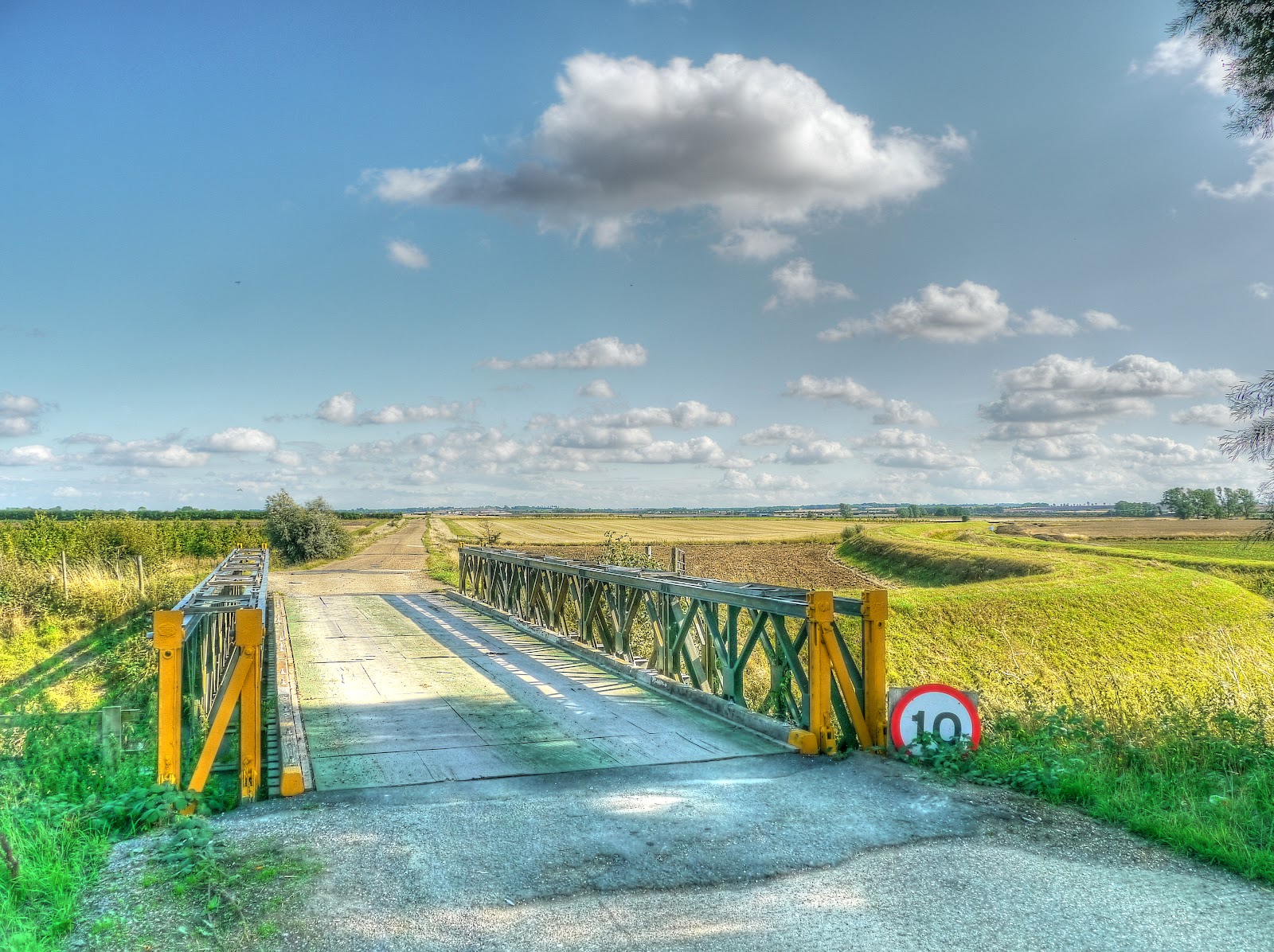
Further into the reserve is a "makeshift" bridge with what look like wood panels for the road surface. The stream it crosses finds its way to the River Great Ouse passing under the CGB first.
Once again I found myself crossing the A1096 just outside of St Ives at a difficult time - it is a lousy spot for Sustrans 51. I guess there was little alternative although there is an island in the middle of the road acting as a refuge. You have to rely on kind drivers though. After cycling through St Ives and back down onto the CGB a quick stop before crossing the River Great Ouse to take a picture of one of the several lakes in this area.

Then I headed back down the CGB cycle path - now what I would like to have done is just get my head down and pedal - however at this end of the high-quality path the track is rather tricky. Where it flooded, over the Winter months and beyond, the track got very soggy and muddy and rutted. I seems that the contractors have attempted to alleviate the problem by dumping heaps of loose gravel. This works for large motor vehicles but makes it very unpleasant for cyclists. In addition, I think that the mud has been puddled and so rainwater tends to pool and then passing maintenance vehicles churn up the mud - leaving this sort of path. In the main the cyclists have tried to stick to the slightly higher ground and worn a thin path to one edge whilst avoiding the more rutted bits.

You can see here that water quickly collects in the ruts and despite the extra gravel added the path has once again worn through to mud. Cyclists at this point have either used the ridge in the middle or to the right. Just after the ruts is a chunk of loose gravel to test your bicycle handling skills further.

Here again is a typical response to the flooding - dumping a load of loose gravel down - in fact I think there are some areas where after the flooding extra gravel was dumped several times.Despite there being little evidence of much work taking place on the CGB there are vehicle tracks on the maintenance path - with the ruts getting deeper. Here the cyclist has to stick to the right of the path.

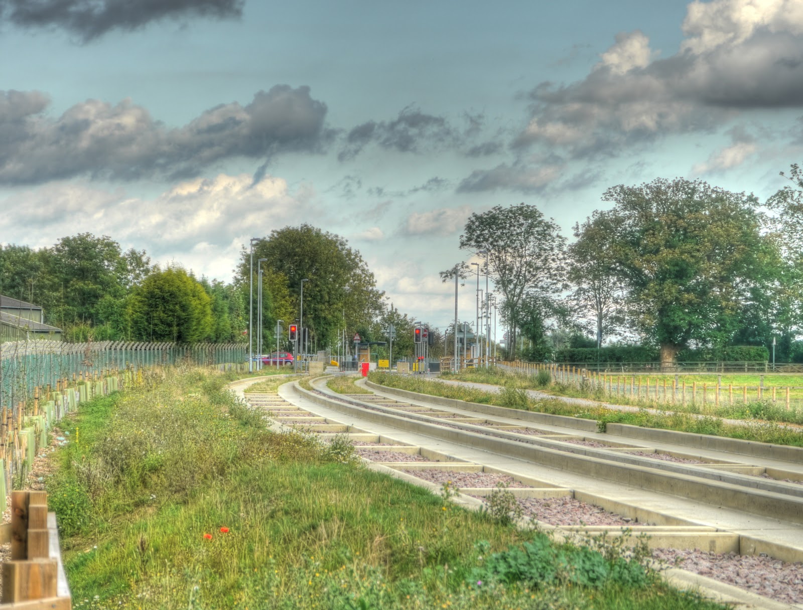
But of course what most users of this route do is stick to the concrete tracks as this cyclist has done. You can see how much higher the CGB tracks are compared with the maintenance path. I do wonder how they thought that the cycle path would be OK if the concrete tracks needed to be so much higher to avoid being flooded?

A close-up of the same spot as in the last couple of pictures. You can either cycle on slimy mud or loose gravel!

Once you are way from the St Ives end the track is pretty reasonable and quite tolerable if it were to be kept to this standard. It looks as if an old hedgerow has been ripped up and a new one planted. I wonder, was this paid for as part of the CGB costs?

One thing I noticed was how different bits of the ballast between the tracks appear - you can see that they are clear of weeds until just before the bend and then it becomes very weedy. Up in the distance is a cyclist and a jogger - both on the concrete tracks.

This picture was taken from the same spot looking the other way. The ballast remains clear for a short distance and then becomes very weedy again. I had thought that they had just run out of weedkiller but after noticing this I wonder if the track construction is different for this curve compared with either side?
Looking back the other way again I had meant to take a picture of the cyclist who was now getting closer - in my haste to take the picture I had not noticed that my camera had focused on the weed sticking up in the foreground.

I did wait for the cyclist to pass and took another picture - here he is.

St Andrew's Church , Swavesey. There is another Swavesey website. The MG Owners Club is one of the main sources of employment for the village apparently.

More evidence of work taking place - planting of trees/shrubs. What about the six issues that need to be resolved before hand-over I hear you ask? Well I don't really - but it is the question that comes to my mind. I realise that I don't cycle along this track much during the working day - but there seems to be very little work on the problems that have been identified. Why is not more happening both from the Contractor's side and from the Council - when is this going to be resolved?

I mentioned the Religious Travellers' gathering near Swavesey - I was surprised how many caravans there were - but it all seemed pretty quiet with quite a few portaloos in evidence. This was the same field that the Cambridgeshire Steam Rally was held - I can't recall that causing as much fuss or "requiring" the presence of the police Helicopter.

Further down it looked as if some kindly burrowing animal (rabbit, badger?) had done a bit of weeding. The stretch near Windmill Hill bridge seems to have a rabbit problem and there were five or six similar holes along the track-way. I think they are rabbit holes, but the size of them made me wonder if perhaps a larger animal was responsible.

After taking the picture of the "rabbit hole" with a concrete roof I looked back to see what looked like rain in the distance - time to get a move on. (Weedy tracks again on this stretch.)

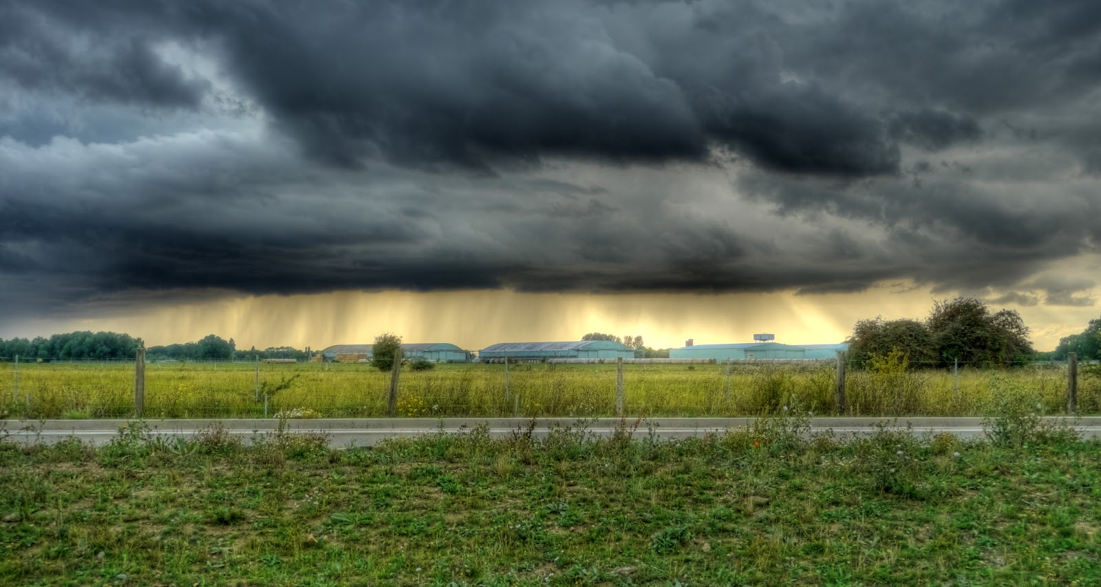
The CGB passes near to the Oakington Immigration Reception Removal Centre - which is shortly to be closed and will be where the new town of Northstowe gets built. The site used to be an RAF base and the link has some pictures of the derelict buildings. These are some of the old hangar buildings and by the looks of things the rain was getting closer.
At this point I nipped home as fast as possible - but still got caught in a torrential downpour. I was wet through and squelched in my back door where I had to divest myself of a load of wet clothing before being allowed in the house! I was given a towel though! Actually the rain was not too cold so it was not terribly unpleasant and I was not out in it for long.
I still managed to count the 31 cyclists using the CGB concrete tracks compared with 3 using the cycle path (not including me). On my way round I also counted 10 cars parked in the advisory cycle lanes on Gilbert Road.
Oh, I nearly forgot, I detoured along a byway off the CGB, near Histon, signposted towards Girton - but I decided to try and outrun the rain (without success) and so got back onto the CGB. I will have to try it out the next time though.
This comment has been removed by a blog administrator.
ReplyDeleteNeeding to get to Swavesey last Sunday, not for the traveller's event though, I
ReplyDeletedecided to use the bus-way from Cambridge. I started on the concrete but
switched to the gravel when the surface improved. However by Longstanton I was
so bored with it that I dived off down a bridleway and used the minor roads the
rest of the way. And a bit of fairly major road where the Longstanton bypass,
not on my maps, cuts off the old Over Road. NCN51 used to go that way, but
now it's apparently along the bypass, on the main roadway. Well done
Cambridgeshire County Council!
Looking at the Sustrans map it looks as if there is a planned tweak to the Longstanton bit of the route which will bypass the bypass by going through the back of Longstanton along a footpath. Although the route it shows now appears to run alongside the bypass. Indeed the Streetmap map does not even show the bypass at all. Too many maps - although the OSM Cycle map seems correct.
ReplyDeleteThe bypass is shown on the O.S. online maps, but the old road is still marked as a long-distance National Trail. Which I suppose it is, provided you can get the bike over an armco barrier and a steel gate. On the way home I tried Tippler's Road and
ReplyDeleteUtton's Drove on the way out of Swavesey, but the latter has loose largish road shavings put down, and isn't worth using until the tractors had pounded them down more.