Sunday, April 29, 2012

A wander by bike around Wadlow Wind Farm: Part 3/3

Saturday, 28th April 2012: After  a look at the Wadlow Wind Farm what could be better than checking out a new route – well, frankly quite a few things could be better, but since I was in Pampisford it seemed like a logical thing to do. After turning off the A1307 along the Pampisford road you can either avoid Great Abington or go through it. That is of course tke beauty of a bicycle, a slightly convoluted route can be more pleasant and interesting than a route made up of straight bits. I went around down the High Street, Church Lane and onto Bourn Bridge Road. I wonder why it is called after Bourn Bridge – the bridge passes over the River Granta?

The route I was checking out was a footpath from the Abington area to Babraham.  Without it the choices are either to go over the Fourwentways roundabout or down to Station Road and join the A505 and try and cross onto the High Street to Babraham. Either route is not going to be pleasant on a bicycle and certainly not one you would want to cycle along with a family. On the OS map the area is called Four Went Ways – presumably after the crossroads it used to be.

If you look at the OSM map cycle view the route is shown as a cycle way. When I got there is was marked as a footpath, and when I got to the bridge there was a no cycling sign and a gutter to assist in getting you bike over the bridge – confused. I have found it difficult getting definitive answers on what paths allow cycling and what paths don’t. It is legal to cycle along roads, byways and bridleways but not pavements or footpaths. However for footpaths and pavements the laws (and punishments) can be different.

The real issue is how can you tell – we’ve all seen examples of poorly signed shared-used pavements barely wide enough for one let along two bikes to pass. Cycling infrastructure doesn’t always get well maintained and the “Cycle end” marking can get lost and signs not replaced.

The trouble is, unlike public rights of way for which there is on-line support and which are well-supported by OS maps. OS maps do show the major Sustrans routes as either green dots (on road) of green circles (off-road) as well as footpaths (red-dotted lines), bridleways (red-dashed lines) and byways red-crossed lines. Which are all in this section of map

How can I tell where it is legal to cycle? That is where the OSM Cycle map is useful – but it probably has little legal status. (There is even an Institute of Public Rights of Way and Access Management (IPROW).)  Here is the Cambridgeshire County Council rights of way map - - but not cycleways and not definitive.

Here is the IPROW FAQ for riding your bike.

On what types of routes do I have a right to ride my bike?

On all the categories of public rights of way except footpaths. It is not an offence to ride on a footpath, but may be a trespass against the landowner. However, it is an offence to ride on a pavement beside a carriageway and also where a traffic regulation order or a bylaw is in place to prohibit cycling.

And the answer is I am not sure quite what the status is. Although this Cambridgeshire County Council reference suggests that discussions with land owners and parish councils are on-going.

Footbridge over the A11 from Pampisford to Babraham

Here is the Bike Route Toaster map and link of the ride. It is just 50Km/31 miles in length and as you might expect there is a climb, well for the flatlands anyway. Let’s face it you wouldn’t expect a wind farm in a valley. Don’t worry it is not that bad it reaches 100m above sea level – just, and you start from around 7m.

Although it was great fun to get out in the rain I did find that the tracks and byways were a little slippery so after “discovering” an interesting route from Abingdon to Babraham I made use of various cycleways to get back (such as the CGB cycleway)

Map of my ride to Wadlow Wind Farm

I have noticed this bridge when driving down the A11 but apart from its distinctive shape not given it much thought. At least they provided a bridge and didn’t make users of the footpath run across through gaps in the barriers like further up the A11 near Barton Mills. I blogged about it here, the picture is halfway down.

Footbridge over the A11 from Pampisford to Babraham

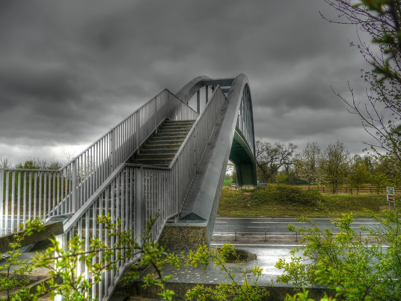
I know – way too many pictures of this bridge – but I might not go this way again for a while. The slope of the steps was also not bad, it as much easier getting my bike over this bridge than the Lodes Way footbridge over Burwell Lode (picture number 5).

Footbridge over the A11 from Pampisford to Babraham

This is the view looking up the A11 towards the Fourwentways intersection. The oncoming fourth car back in the middle lane has only one working headlight. A couple of days later it will be Speed Awareness Week – and using my powers to look into the future on the 1st  of May the Sussex police will catch more than 3,000 people motorists speeding. Whilst many drivers will tell you that speeding is not a problem they forget that the faster a motor vehicle is travelling the more serious the consequences if there is a moment’s inattention or a tyre problem...  Not to mention the noise.

The A11 near Fourwentways

Phew is that the last of the bridge pictures I hear you think, no sorry. But this is the path after you cross the bridge.  I do enjoy finding new routes that I have yet to cycle along – nothing beats the element of discovery. I know it is not quite like climbing Everest or skiing to the North Pole – but enjoy it.

You could see that others have cycled this way and even with the rain it was quite cycle-able.

Footpath from Pampisford to Babraham after crossing the A11

This is the last bridge picture – in this post anyway as the main subject anyway. This is the view from the other side. As you can see the “riding of pedal cyclists is prohibited”.  I wasn’t going to cycle up the gutter anyway – generally the traction on wet metal is none too good.

Footbridge over the A11 from Pampisford to Babraham

After Babraham there was a “proper” cycle route across to Sawston – this one was purpose built and I think was built as part of Cycle to School funding and jolly nice it is too. Perhaps not up to Dutch standards – but at least it is set away from the road a little bit.

Sawston-Babraham Cycleway

I then joined the NCN11 route from Sawston up to Cambridge, with the bit leading to Addenbrookes “decorated” with Double Helix of DNA by Katy Hallett.

Sustrans Art: Double Helix on NCN11 near Addenbrookes

And up in the background is the ever expanding Addenbrookes site. Although there is controversy over its lack of helipad facilities. Although it has a major trauma centre if you get choppered in you have to land at the local Golf Course and get driven down. The delay can add a crucial 20 minutes onto the journey time. The are has two charities providing helicopters and medics but no landing pad – joined up – non?

When ranting on about the lack of evidence concerning the use of cycle helmets although many idle commenters seem to think they should be compulsory I sometimes mention falling down stairs as an example of an activity that has its dangers but which no-one would dream of dinning a helmet for. I think that partly it is because such accidents don’t get reported – well unfortunately here is the report of a local man falling down stairs. He was taken to Addenbrookes by land ambulance but assisted by the Magpas Helimedix team.

Addenbrookes Hospital

And this is the actual cycleway – this is better than cycling along a road – but isn’t that wide unfortunately.  I also find the DNA decoration can be a little slippery as well I avoid cycling along it and avoid the edges coloured stripes as well.

What I hadn’t realised is that there are also four species of tree planted along this bit of the route to represent the four genome bases.  This represents the 10,000th mile of the National Cycle Network (NCN) and was opened in 2005.

Sustrans Art: Genome Stripes on NCN11 near Addenbrookes

I turned off the NCN11 route and carried on into Cambridge on the Southern Section of the Cambridge Guided Busway. Which has been in the news a little just recently. With all the rain we have been having it has flooded – well the important but has (the cycleway). Naturally I have been for a paddle and will report on it in a few posts time when I catch up. I will also mention the kindness of a bus driver who waited for me to pass through the floodwater safely before he carried on his way – thank you to him.

The legal battle is inching along, at the same pace the original construction did it seems. with BAM Nuttall launching a £43m busway counterclaim. According to the article they seem to be going after the Project Manager hired by the CCC – Atkins.  Apparently the failings of the Project Manager were “serious and numerous”.

A while ago I mentioned how the provision of a free school bus from Oakington to Impington was being withdrawn and the parents were appealing – well “Parents fail to overturn bus decision”. Apparently residents “may have little choice but to drive their children to school”. I think overall it would be better for kids to cycle to school and the CGB cycleway seems are very reasonable route IMHO. The trouble is there is still a real perceived concern about the dangers.

There are multiple strands to the problem and i don’t have particular answers. I am sure that there is some degree of over-protectiveness creeping in. However there also seems to be a reluctance to acknowledge the fear parents have of the roads for cyclists. The desire to have 20mph speed limits (for cyclists’ sake) does not get acted upon.  Yet most commuters (two in three) feel that most roads were unfit for cycling in a survey by the charity Brake.

The trouble is here in the flatlands there is pressure to create more housing – “New towns will create traffic time bomb say villagers” yet we don’t seem to be able to plan more sustainable ways to help those new inhabitants get around.

The problem is not to get people like me cycling more – I have given up the Lycra and and pushing at the end of middle-age. We want to made the cycling appealing to those who aren’t cycling. We want cycling to be seen as safe by parents letting their kids cycle to school, by mums cycling their toddlers around by older people cycling to the shops.  Telling them they need more training and that there should be stiffer penalties for “Drivers who kill” is a bit of shutting the gate after the horse has bolted.

It would seem to me that the price being paid to provide routes for motoring at the expense of routes for cycling and walking is too high.  We even have the expense of policing the roads. A local crackdown by Police on road safety stopped 100 vehicles – that is a lot of vehicles for a day’s work. It implies there are loads of “unsafe” vehicles sharing the roads with cyclists and pedestrians.

Not surprisingly Rising petrol costs boost cyclist numbers (in Southampton according to a survey). Apparently 1 in 3 cyclists have increased their levels of cycling in the past three years.  The principal safety concerns of cyclists – drivers not paying attention.

Sorry another bridge.

Guided Busway Spur to Addenbrookes Hospital

As I cycled through the Cambridge Railway Station it did suddenly become cyclist unfriendly – roll on the Chisholm trail and also roll on better cycle parking. They are trialling some double-decker cycle bays and yes I have some pictures – in a post yet to be written, In fact the pictures have only just been downloaded.

Oops another bridge got into the picture – the Carter Bridge.

Whilst we (or rather I) go on about not wanting roads all over the place – they only attract cars and lorries  - parking is also a problem in Cambridge. Apparently in the US surface car parks take up land roughly the size of Puerto Rico – just under 3,500 sq miles. In a BBC article – “Is there a worldwide parking problem?” it reports on a book discussing the issue. There are now around 600 million cars in the world and that is growing.  the author argues for better car parks – I would argue for fewer cars.

Nowadays there is concern that if town dwellers devote their garden space to hard-standing for cars, unless it is semi-permeable it can lead to flood risks (the report of Scottish but it gives the picture).

Crap Cycle Parking – Cambridge Railway Station

When I looked at the map to plot my route on Bike route Toaster I noticed that another cycle way North from the station. I sometimes use St Barnabas Road. I was taking a taxi home and noticed that the driver went that way. Why well there are traffic lights that make it easier to join Mill Road, It also makes it easier for a cyclist as well.

What I hadn’t realised was there was a route north by crossing Mill Road and going down Gwydir Street and then Hooper Street/Ainsworth Street – so I must give that  go. Although cycling is slower than driving it doesn’t mean I want my journey to be even slower because of congestion and going around the houses. If anything cyclists prefer efficiency – which is perhaps why some don’t stop at red lights.

This time around I went through Coldham’s Commons – which isn’t too bad – the thing I hate is that there can be an interminable wait when crossing Coldhams Lane from Cromwell Road into Coldham’s Commons.

Mind you I don’t mind stopping to take the occasional (and even the regular) picture. The recent rain had brought out the buttercups (ranunculus) on the Common.

Buttercups on Coldham’s Common

As you can see here they are dotted along the grass. Do cows like them? well whether they do or not cows are susceptible to buttercup poisoning – it can cause the milk to be bitter and red-tinted. You learn something new every day"!

Buttercups on Coldham’s Common

And finally chapeau to the 10,000 cyclists who braved the rain in London to support the Dutch-style cycling revolution. As Cyclists in the City says: “It’s time to make London a city that’s designed to people to cycle instead of drive”. The issue has become a key part of the mayoral elections. The trouble is whilst Boris might be a cyclist it seems he doesn’t necessarily get cycling for all  – according to a podcast I listened to on the Bikeshow.. (In fact one Blogger (Vole O’Speed) would argue that he is not sincere in his commitment to Go Dutch. (Here are more pictures on Cyclestreets.)

And finally – Raleigh has gone Dutch and here are some of their historic posters. And just as I was finishing this post it turns out that at Weetabix has gone Chinese (well 60% anyway),

A wander by bike around Wadlow Wind Farm: Part 2/3

Saturday, 28th April 2012: They seem to have decided to build a Wind Farm in an area I cycle around. There are two decent byways that run along two edges of the new development. Last year I was amazed at how many wind turbines are being put up in Scotland. My wife and I had delivered our daughter to University. We went up on the east side and back and on the west. It seems that one of the Wind Farms we passed in Scotland will also build in some cycling as well.

There also also wind farms in the Norfolk area that I have cycled by, but not through.  It seems that there are concerns about them ranging from a blot on the landscape to problems of light and noise pollution through to causing problems for birds (either through collision of affecting their navigation).

To be fair I’ve have no real idea which of these is true, although clearly they do make a visual statement. The trouble is you want to site them well away from civilisation to minimise the impact, but you want to put them close to civilisation to minimise the costs of connecting them up to the power system. You also need them to be somewhere windy as well.

The hill chosen for this Wind Farm lies between Great Wilbraham and Balsham near Wadlow Farm – hence the name Wadlow Wind Farm. It will be capable of meeting the annual needs of 15,000 homes or 29% of the houses in South Cambs. I assume they have average out the generating capacity because sometimes the wind doesn’t blow. Apparently construction is due to start in earnest. There is a map on page four and a more detailed map on page 7 of this pdf document which details the Non-technical Summary/environmental impact.

It would seem that the Wind Farm will be particularly noticeable from the Fleam Dyke (part of the Harcamlow Way). Part 1 of this series of three posts got me to Wadlow Farm. After that there was an uphill cycle along the road from 54m to 100m above sea level to Green End farm where I turned off along another byway – this time to Balsham. Depending upon how easy this byway was my plan was to either return to Cambridge along the Roman Road or some other route that I hadn’t decided upon.

The first part of the track (which doesn’t appear to have a name on the maps I have looked at starts off with a reasonable gravel surface. I stopped to take a picture of the ground works of one of the other wind turbine areas.  They don’t look much at the moment but when the 13 turbines go up it will be clearer. I reckon this will be T6.

Wadlow Wind Farm ground works – Turbine 6 maybe

Here is the Bike Route Toaster map and link of the ride. It is just 50Km/31 miles in length and as you might expect there is a climb, well for the flatlands anyway. Let’s face it you wouldn’t expect a wind farm in a valley. Don’t worry it is not that bad it reaches 100m above sea level – just, and you start from around 7m.

Although it was great fun to get out in the rain I did find that the tracks and byways were a little slippery so after “discovering” an interesting route from Abingdon to Babraham I made use of various cycleways to get back.

Map of my ride to Wadlow Wind Farm

If you look closely, and even if you don’t you might see some similarities between this picture and the first in the Post and the next one two as it happens. I tried to take a panorama shot, which required stitching them together.  I couldn’t get the colours to match though so I abandoned the panorama.

Wadlow Wind Farm ground works – Turbine 8 maybe

And there is the post in the last picture a bit further along. I am sure I could do a better job of identifying which clumps of trees is which and from where I was standing which site is which – but that’ll delay the Post even more.

Wadlow Wind Farm ground works – Turbine ? maybe

As I mentioned earlier the byway starts with a reasonable decent gravel track to the left, almost as if there was a gravel pavement alongside the rutted track. At this point the rutted track is all that is left. he good news is that it does go downhill. I cycled along the line of mud hard alongside the left-0hand hedge. My tyres aren’t very gnarly so the main challenge was watching out for rear or more importantly front wheel slip. I didn’t dab once though.

Byway to Balsham alongside the Wadlow Wind Farm

On the other side through the hedge – a massive yellow field. What a surprise.

Oil Seed Rape alongside the byway to Balsham

As you can see the roads within the windfarm site appear to be in place ready for the deliveries of the masts and turbines. This is marked on the detailed diagram (page 8) as the “new track to run South of existing hedge”.

Wadlow Wind Farm – Site track

As with all down hills there is a price to be paid – in this case the track climbs up about halfway along its length. The trouble is that the ruts were deep and slippery. I picked the middle one – the puddles didn’t look as bad. The trouble is if you think to hard about keeping you wheel in the rut you end up having problems. The best thing to do is relax and pedal steadily only loosely steering the bike. That’s the theory, what happens is that you over steer whilst the rear wheel slips and then the front wheel gets knocked by the rut and at that point the best thing to do is dab you feet down. It is either that or risk emasculation (if you are a bloke).  I reckon dabbing you feet is the best bet personally.

After one dab I relaxed and managed the rest of this hill in the middle lane without anymore dabs.

Byway to Balsham – don’t veer to the left or right – veer straight on

it was this bit of track that convinced me to find a different way back to Cambridge. The track down from Balsham to the Roman Road is tricky at the best of times so I decided to head out towards Hildersham along the Hildersham Road. It isn’t too busy and undulates. You also get an interesting view of the old Linton Water Tower, a landmark standing on Rivey Hill looking over Linton. Rivey Hill appears on the OSM map, but not the tower?

It was quite a distance and I took seven pictures to create this HDR shot – it turned out better than I expected.

Linton’s Water Tower – a landmark on Rivey Hill

A bit further down the road is what looks like a rather wide hedge – it is the Roman Road passing along the undulating countryside. I could have turned along it – but the road made for easier cycling.

The Cambridge Roman Road seen from the Hildersham Road

After that the route dropped down into Hildersham a rather nice village with a ford. Although the road now has a rather nice white bridge with a pedestrian walkway. The post has “Headly Mill Road Cambridge” inscribed on it.

Hildersham bridge over the river Granta

And here is the ford – even with the recent rain it still seems quite tame – although I cycled across the bridge. The road surface can get a little slippery and I don’t fancy the ride home if I got wet. Although tragedies do occur – even river water can be a forced to be reckoned with. In the case in the link there is a suggestion that the GPS was to “blame”. Whether it was or not it is a reminder not to drive on automatic pilot.

Hildersham Ford across the River Granta

And like all good bridges it does have an “information board” although there are no pictures. It was a gift to the village and built in 1886. They built them to last.

Details of the bridge over the River Granta, Hildersham

And just in case you get the idea that I am a fair weather cyclist it was raining and you can see the rain drops as they land. At this point I though I would head to Abington and see whether the off-road route through to Babraham had been opened up – there would be another bridge to check out.

Rain falling into the River Granta, Hildersham

After crossing the rather unpleasant A1307 I set of to Pampisford. I have never heard of the River Pampi – or its ford! It used to have a station though – now under the A11.

A wander by bike around Wadlow Wind Farm: Part 1/3

Saturday, 28th April 2012: This “business” of cycling is interesting – well to me and I don’t actually mean business. I guess like anything there has to be a reason to get out on your bicycle. We each have different motivations and we each motivate ourselves in different ways. Sometimes there will be a key reason and sometimes there will be a set of reasons. I have also noticed that in my case there can sometimes be a barrier that stops me from cycling.

My main barriers to cycling  are wind, illness, cold rain and warm rain. At some point in the hierarchy time figures, but time is generally the issue it could be. For instance if I have meetings in and around Cambridge my bike is an ideal way to get around. If I have meetings in London then a bicycle is a good way to get to the station, although sometimes it can be very difficult finding a cycle-parking space. Although that might change sometime in the unpredictable future – “Countdown to next major stage of cb1 development” mentions the cycle park. Mind you the cycle park will now share a building with a hotel rather than a car park – I will believe it when I see it. It also includes plans to triple the size of the Cambridge rail station’s hall.

Another motivation is to save money, that is not why I cycle, although it is how I then justify spending money on my hobby. Apparently “One in three households forced to choose between ‘meals and wheels’’ after petrol costs soar”. The trouble is we have become so accustomed to a car-dominated society that it colours own views about what the roads are for. More importantly it also makes it very difficult for those without their own transport because cars win at the expense of public transport.  It was not a surprise to see the article “Why drivers can’t rely on those miles per gallon figures”. Once you have been sold the idea of a car as your “personal castle” it becomes very difficult to wean yourself off. We car owners become complicit and blame everyone but ourselves.

You only need to read the comments about cyclists and their supposed transgressions to see how resentful motorists have become and cyclists are an easy target. Yet, one more cyclist is one less car in front. if all the flipping cyclists in Cambridge drove instead it would be total and utter chaos.

There are resentful complaints about cyclists chaining their bikes up all over the place at the Cambridge railway station, just think if they were cars. We also seem to ignore the fact that car drivers do similar things. Apparently the Cambridge Council car park is to be closed to the public because car drivers were flouting the rules. Of course the reality is when a motor vehicle flouts rules it has more impact, forgive the pun, whether in an accident, taking up space or creating noise and air pollution.

The trouble is motor vehicles and pleasant areas to live are a contradiction in terms. Take a village like Fenstanton – it got chopped into two pieces by the A14 (the link is bare at the moment – not sure why – hopefully it will come back)  and local inhabitants have a major road running right next door.

So what inspiration did I use to get me out in the rain – we have “flood warnings” and I did think about a road route – but having recently read an update (in the Carpenters Arms, Wilbraham on the Wadlow Wind Farm I thought I’d check it out and see what sort of progress there has been. Interestingly a study has shown that Wind Farms heat up the local climate – by around 0.72C over 10 years. Mind you the flooding here has not been that bad so far compared with Tewkesbury.

On my way out I did see some me scooters which reminded me that I had seen this lot out  the week before but wasn’t quick enough with my camera.  Apparently they congregate along Bridge Street every Sunday, but they are now being moved along apparently the Council received complaints from local businesses. Although the News asked a couple of places and there were no complaints. It seems a shame to me that we cannot tolerate a little local colour. Perhaps it they spent the time wheelying up and down in might be a different matter – but it doesn’t sound as if they do.

I also noticed that the cattle grids on my way out of Cambridge on the NCN51 through Stourbridge Common and Ditton Meadows had been temporarily “planked” over, presumably for the “Riverwalkers to help Macmillan” walks on Sunday 6th May.

And finally a quick mention for another pub – I haven’t been in for a while but have been bother with friends and family – “New-look Bakers aims to whet appetites”. The last time I cycled through Fulbourn I noticed that works were taking place and wondered if that was the beginning of the end – but no it appears to be the beginning of another beginning. Here is a link to the map and here is their website, well the brewers website the Google search threw up an address that didn’t work.

At this point we had some mains glitches and after a short while my computer froze -  I had to hold the power switch to get it to turn off and reboot. When I do that the Raid disks perform a self-check.  I can still use the computer – it just runs like a drain, v   e    r    y    s   l   o   w  l   y…  Although I had to reload the pen pad drivers as it couldn’t work out the size of the pad is use instead of a mouse for drawing input.

Anyway on with the ride I headed out along the NCN51 and then dropped down through the Wilbrahams and up towards Wadlow Wind Farm – well the site of anyway.

I did stop just by Quy Church (St Mary’s Church) to admire these bluebells in the Churchyard.

Bluebells in the Churchyard – St Mary’s Church, Quy

Here is the Bike Route Toaster map and link of the ride. It is just 50Km/31 miles in length and as you might expect there is a climb, well for the flatlands anyway. Let’s face it you wouldn’t expect a wind farm in a valley. Don’t worry it is not that bad it reaches 100m above sea level – just and you start from around 7m.

Although it was great fun to get out in the rain I did find that the tracks and byways were a little slippery so after “discovering” an interesting route from Abingdon to Babraham I made use of various cycleways to get back.

Map of my ride to Wadlow Wind Farm

One of the reasons I came this way was to get another picture of the brow of the bridge over the A14 where the Bottisham cyclist was knocked off – the challenge for motorists is that it has a slight brow and the edges of the approaches to the bridge have large “hedges”. From experience motorists really don’t like to be delayed by cyclist and most won’t wait unless they really, really have to.  The possibility of oncoming traffic doesn’t always seem to be enough reason.

A14 Bridge between Wilbraham and Bottisham

The road from Bottisham to Wilbraham is called Wilbraham Road – no surprises there. As you might expect there were also yellow fields – here is the view looking East-ish, if you follow the link you can see the line of pylons on the map – they look further way in real life.

Oil Seed Rape on the Wilbraham Road (Near Little Wilbraham)

After cycling through the Wilbrahams I turned off along Mill Road – it doesn’t look promising as it appears to be a rat-run road to/from the A11. You do find cars tearing along the road, but I guess it it probably worse during the rush hour(s). I stopped just by the railway bridge, which passes over the Cambridge to Ipswich line. Although my first picture was along the lines of pylons heading north-east. they do head over the area where the wind farm is being built so presumably it will be able to connect directly to the Grid.

Electricity Pylons heading north east after crossing Mill Road, Great Wilbraham

Of course I couldn’t, 2not2 take pictures of the railway track. Seen from here the cutting is quite deep and there are even hills in the distance. This is the view looking towards Six Mile Bottom.

Railway line heading east after crossing under Mill Road, Great Wilbraham


And since I had stopped I also took a picture of the much straighter view towards Fulbourn. if you zoom into the picture you can just about see where the Fulbourn Railway station was, it is now a grain company.

Railway line heading east after crossing under Mill Road, Great Wilbraham

After crossing over the top of the A11 this is the sight. The first time I cycled along in a while I thought they had done the road up because the area was going to be used as  a recycling plant. On reflection it might have been because they are using this route in to Wadlow Wind Farm. You can see the construction road carry almost straight on up the hill.

The Road from the A11 to Wadlow Wind Farm

And just in case you weren’t sure a sign point out Wadlow Wind Farm – up the hill.

Wadlow Wind Farm – straight on

The road becomes a T-junction although now you can also go straight on. Right takes you up a hill past the Old Cambridge Road Plantation and left towards West Wratting Valley Farm and Valley Farm Cottage. I wonder if they will here the thrum of the blades as they spin? The map shows Camgrain and Wilbraham Quarry Waste Management here. Camgrain is a farmer-owned storage Co-op. I think this link shows pictures of the operation.

After climbing some way up the hill I stopped for a breather to take a picture of the old quarry. Although it looks as if the quarry might still be in use?

Wilbraham Quarry

It is/was a chalk quarry and looks as if there is still some chalk around – although it could be to do with the waste management (they bury it?).

Wilbraham Quarry – a tractor

A bit further up the hill and you can see the ground works for one of the pylons.

Wadlow Wind Farm ground works

The track rises from around 35m to 75m above sea level. It was also quite muddy and had a few large puddles along the way. I made it with no dabs though. I think that group of trees is the Old Cambridge Road Plantation.

Old Cambridge Road Plantation, on the byway near Wadlow Farm

And this is the Cambridge Hill Plantation, on this link the triangular wood is the Old Cambridge Hill Plantation and the long thin strip to the south might be the one in this picture. Alternatively it could be The Pendant, another wood.

Cambridge Hill Plantation, on the byway near Wadlow Farm

And this is the rest of the hill to climb, muddy rutted and you have to pick your way – no dabs though. The back wheel also slipped a bit and the pedals hit the edges of the ruts. I blame the weather.

On the muddy and rutted byway near Wadlow Farm

There is a good view looking down towards Cambridge though. Well I think that is where I was looking when I took the picture. My computer is so slow it won’t load up Picasa so I can get a better look. Actually you can see what looks like the church at Six Mile Bottom, but I seem to remember looking in the Cambridge direction – strange.  You can see the pylons in the distance that ought to give me a clue. In fact I think it is Six Mile Bottom Church and in the very far distance I think I can make out Ely cathedral – which kind of hangs together. the cathedral is in the third pylon gap from the left.

Looking towards Six Mile Bottom from the byway near Wadlow Farm

This is much easier to identify it is Lark  Hall with Chilly Hill and Daddy’s Bush behind on the hill.

Lark Hall near Wadlow Wind Farm

And finally, well for part 1 of 3, the track finally heads down hill towards Wadlow Farm, with one of the barns just visible to the right of the picture. There was quite a big puddle at the end of the track, just as it reached the road. You can also see cowslips growing on the bank alongside.  The track was bumpy but speedy.

Down the track to Wadlow Farm

The only trouble was having reached the dizzy heights of around 75m above sea level the track dropped down toe 54m before climbing back up the road to the magic 100m above sea level. Actually there is nothing magic about it and it isn’t even that much – except to a Flatlander. Actually the road was easy, not because I am in any way fit, but just because the tarmac gave the wheels traction in it was easy in comparison.

Saturday, April 28, 2012

My new/old bike is almost ready for service–just the crash test to perform

Sunday, 22nd April 2012:  Oops, a quick confession, I got the date, it should have been Saturday the 21st, ah well wrong in my last sequence of posts. I won’t go back and change them now.

I am practically a week late in writing up this post – a good job it is not meant to be topical news.  As I sit here the rain has been drizzling all morning although when I cycled down to buy a newspaper it was barely a sprinkle. If it rains I normally wear a coat and take a plastic bag to keep the newspaper from getting wet. I did neither and so cycled home holding the newspaper behind my back. It did the trick and such is my “oneness” with my new/old hybrid bike (aka Maisie Marin) I managed not to fall off either.

I must admit to reading the Time with a feeling of Christmas was I was a young lad. Why, well they had a feature – The Wild Cycling Guide, 20 great routes through Britain’s most beautiful countryside – just the ticket, new places to explore. Unfortunately it felt like I’d been given a pair of socks by an aged Great Aunt. You’ve guessed it the great Flatland of East Anglia (well Cambridgeshire) doesn’t have sufficiently beautiful countryside. Which isn’t true – but in a conventional sense I know what they mean, what’s worse we seem to be blighting bits and pieces all over.

It isn’t the Times fault though and I feel that there focus on Cycling  is a good thing, although it will take a lot to change the middle-aged male stereotypical thinking of some of those in power. Which either blatantly misunderstands what cycling can be or even when it involves someone who cycles errs on the macho side. I really enjoy the Josie Dew series of books and would recommend them to anyone looking for a bit of cycling inspiration. Indeed they gave me the inspiration for my somewhat less adventurous cycling tours (Bangkok to Saigon and India and LeJog). So I was interested to read the Cycling Lawyers take on the Transport Select Committee with input from Jon Snow and Josie Dew. If nothing else read his last sentence and no Josie  is still with us – but she embodies much of what cycling is really about.

Talking about inspiration here are some cycle trips to be inspired by: The Long Ride Home, King’s Cross to York and Cambridge to York (perhaps you can tell what I am thinking of doing!)

It does mean that as I look at these pictures from last weekend I would prefer random showers to continuous rain – at least when cycling. Still I must get out, I need some fresh air after lunch.  My son and his girlfriend are cooking us all breakfast burritos, although technically it is lunchtime, well mine anyway. I suppose as they have just gotten up it is their breakfast time.

Although I don’t provide a topical analysis of cycling related matters, here are some of the things that have caught my attention in the news recently. Apparently “Cambridgeshire tops crime fighting league table” – it must be all the crackdowns we have. Such as this “Police arrest 70 bike thieves in crackdown” which also informs us of crackdowns on “innumerable” cyclists

Whilst on the subject of crime Speeding drivers escape punishment in city’s 20mph zone shows just how car orientated we are.  Reading the article is like reading an excuse-fest. The issue is getting motorists to obey the 20mph speed limit along Maid’s Causeway.  The article reads as if the police really don’t believe in a 20mph limit giving many reasons such as the need for sped humps or education or larger signs or better speed guns or 2-MPH speed awareness course…   I suppose that it is tough enough catching criminals doing bad things whereas catching people doing anti-social things just earns them grief.  After all aren’t laws suppose to reflect the will of the people – without of course being unfair to minority groups.

It would appear that since I have started writing this Post the issue has mutated to “Police cast doubt on 20mph limit’s future” because speeding is the “norm rather than the exception”, a police chief said. Whilst that might be the case it is a rather dangerous and political argument for a police officer to make.  If, as so many commenters to cycle-related stories on the Cambridge News seem to think, cyclists jumping red lights is the norm does that mean there is another law that can be ignored. It would seem that any laws about vehicles parking in cycle lanes get ignored – and a lot of drivers seem to ignore the Highway Codes advice about driving carefully around vulnerable road users.

I wonder if perhaps the time has come to split the policing of the roads from the activities of catching criminals. Apparently “Staffordshire police officers crash their vehicles 48 times in a year – in their own CAR PARKS” but according to the article they number of accidents have dropped. It would seem that one of the problems is with Police stations often in town centres and with the increase in motor vehicle dependency they just don’t have the space to easily park all of their vehicles.

Which leads into Council ‘holding things up over parking problems’ apparently cars are clogging up the roads in Queen Edith’s and Coleridge and causing the residents problems. Whilst the roads are public it does seem that we often feel that if we live in a particular area then we should have preferential benefits – such as parking.

The ultimate argument in favour of better and more and wider roads always seems to be one of how beneficial it would be to the (local) economy. Yet more roads encourage more wasteful behaviour. A friend who runs a haulage company told me that since the concept of just-in-time struck then his trucks run less full. So “optimising” the use of time de-optimises other factors such as fuel efficiency.

Mind you this is the sort of job I would like – researching pubs.

Anyways – on to my cycle ride, once again dodging the showers as I cycled around Horningsea and Wicken Fen. I took my usual route – but this time cycled along Harrison’s Drove into Wicken Fen for a change.

My picture-taking started after turning off High Ditch Road onto Low Fen Drove Way and I was on the bridge over the A14. In the flatlands the bridges make for good vantage points. I didn’t look for any syringes this time – but syringe finds have been happening in Haverhill recently. This is the view looking back over the fields to Fen Ditton. The hedgerow on the other side of the yellow field follows the line of the old Cambridge to Mildenhall Railway line.

Looking from Low Fen Drove Way towards Fen Ditton

The distance on the Bike Route Toaster Link is not precise as I got the route slightly wrong I took a slightly different route after the Lodes Way bridge of Swaffham Bulbeck Lode. It isn’t that different though. The route is around 54Km/34 miles it is still flat and pretty quiet – you do see a few cyclists though – don’t forget to wave.  Fell free to stop me and have a chat – I’ll probably be listening to my MP3 player – but don’t let that stop you.

Map of My ride around Horningsea and Wicken Fen

This is the view to the North of the bridge towards Horningsea again over yellow fields – stretching for some distance. You can of course see the pylons marching from Burwell to Cambridge and beyond.

Looking from Low Fen Drove Way towards Horningsea

About halfway around Low Fen Drove Way, after crossing the track of the Cambridge to Mildenhall Railway Line (now a private road). I stopped to take yet more pictures of yellow fields, blue skies and white clouds.

Yellow Fields from Low Fen Drove Way, Cambridge

Along the drainage ditches between two yellow fields were three deer foraging for food. They didn’t hang around waiting for me to take my camera out of my bag but did run along the gap before diving into one of the fields and then disappearing.

Deer between two Yellow Fields, near Low Fen Drove Way, Cambridge

This is the same view from without the zoom, you can’t see the deer in the field on the right, well I can’t anyway.

Invisible Deer between two Yellow Fields, near Low Fen Drove Way, Cambridge

At the end of Low Fen Drove Way, just before it reaches the Fen Ditton Horningsea Cycleway, the avenue of trees along Biggin Lane were showing a lot more leaf than last week. I do like the first signs of Spring, but forget just how spread out the “coming into leaf” season is.

Biggin Lane, Avenue of Trees (near Fen Ditton)

After that I cycled up through Horningsea, using the cycleway until it came to an end. Then shortly after passing through the village I turned off along a bridleway to Lode. Just after passing Allicky Farm I stopped to take a picture of some red cowslips in the drainage ditch alongside the track.

Red Cowslips in a drainage ditch near Allicky Farm, Cambs

And this is the drainage ditch in question where the majority of the cowslips are the more usual yellow colour. The track is to the right.

Yellow Cowslips in a drainage ditch near Allicky Farm, Cambs

Although we seem to have had a lot of rain it has been intermittent and fairly light rain so the track across to the village Lode (the old aforementioned railway track) was not too bad for cycling – although I did pay more attention to the puddles that have collected. Harvey’s Droveway at the very end was its usual muddy, rutted and puddled self. This is one of the delights of the countryside – getting away from traffic. This is the continuation of Harvey’s Droveway I think.

Two Horse riders and their dog on Harvey's Droveway, Lode

Once I reached Lode I joined the Lodes Way heading in the Wicken Fen direction. As I was reaching the end of White Fen Droveway/Sandy Road I noticed a burnt out car along one of the tracks that runs perpendicular to Lodes Way so I went back to have a look. The track doesn’t have a name but is just about where White Fern Drove jinks off to become White Fen Drive Way and Lodes Way follows Sandy Road – but straight on.

Burnt out car near White Fen Drove, Lode

A closer look suggests that this was burnt out further up the track, or at least somewhere else. You can’t see any signs of scorching where the sits – although it has been completely burnt out.

Burnt out car near White Fen Drove, Lode

After that detour I headed back along through White Fen, stopping briefly to admire the work of the volunteers who sorted out the mulch mats – between 1,000 and 1,500

White Fen, with newly sort mulch mats

I then cycled over the Swaffham Bulbeck Lode and a short way along the track to go round the back of Highbridge Farm. On the OS map the leg of the track heading to the farm is called Rail Drove. A common crop around here at the moment is turf – quite a lot gets grown and “harvested”. On the second leg of the detour was a field mid-harvest. 

Turf being Harvested near Highbridge Farm, Swaffham Prior

This is the track I took the last picture from, the turf harvesting was taking place on the right hand side. There is another field of turf on the left hand side. This track can sometimes get a bit rutted – these are working route for the farming operations – but it was fine this time around.

Turf being grown near Highbridge Farm, Swaffham Prior

At this point I thought as I hadn’t been up Harrison’s Drove for a while I would give it a go. It is a track through Wicken Fen and consequently suffers from drainage problems. It is also used by the NT for their operational management of Wicken Fen – they drive vehicles along it.  So it can get pretty bad. In places there are muddy bits that have had some form of underlay put down to help protect the track from erosion.

One thing about the activities of the NT, it has improved the interest in the Fens around here and the number of visitors has increased. Let’s hope that the appreciation of the countryside also drives an understanding of the need to protect it.

I should have realised that being a Sunday there might be more than the average number of visitors. Normally at most I see one or two people along this track. At the weekend I might see 5 or 6. This time there we 30-odd people. There was one group of 20 or so who, I deduce from observation of their behaviour, don’t know what to do when a middle-aged bloke comes puffing up behind then ringing his bell.

The ideal in such circumstances is they move to one or the other side, sometimes they will part down the middle. Occasionally I get some dog walker who wants to show me how well behaved their dogs are under voice control. (Not enough – some will chase my back wheel arghh.)  This group seemed to want to cross the track in front of me – some going one way, some going the other. They were more like panicking sheep.  Here is what the track looks like – I was not tearing along the track and do not have an air horn on my bile – just a single ting bell, although I quite like the idea having just looked at them.

I did say thank you once I had gotten through – crowd behaviour can’t be blamed on the individual. I was also quite pleased with my balance – the ruts in the picture might not look tricky but they are not that easy either. In fact I was so pleased that I had gotten through without dabbing a foot down that I decided I ought to to a crash test of my new frame.

I put my left foot down to stop, it rolled and twisted on a rock and it was either crunch my ankle or fall off – so I fell off.  I am getting better at rolling off and so the only thing that was hurt was my pride – still good to know I can do an unplanned and rapid demount onto my back from my new/old bike. And as you do you then think up a little rhyme.

I’d cycled down the road and I’d pedalled up the track
It wasn’t ‘til I stopped that I tumbled on my back

Harrison’s Drove – Wicken Fen – a rutted bridleway

After that excitement I cycle up the bank of Wicken Lode taking care not to test my bike again, although I could have wheeled up and rolled over onto my bike to amuse the walkers some more. Fortunately I really am getting the hang of the slightly different handling of my new frame. There was quite a substantial tree to the left of the lode and to the right if the post in the ground. It has been chopped down – I suppose to protect the integrity of the Lode-bank. I still think it is a shame when healthy trees get cut down. We seem to have so many trees under siege in the UK at the moment.

Wicken Lode

As I cycled along the bank taking care not to get my front wheel deflected by a rabbit hole and then into the Lode for an early bath.  I was able to test my rapid flying insect extraction and cycle handling skills. though.

I think I mentioned that when I got my bike back, with its new frame, the first time I indicated to turn right the bike swerved about as my left hand seemed to exert more pressure on the handlebars and there was no counter-balance form my indicating right hand. Well this time as I instinctively reached up to pull the thing buzzing in my mouth out despite being on a bumpy mud bank the steering hardly twitched.

It was a good job I didn’t tumble into the Lode as I would have been run over. There was a boat coming down from Reach Lode.

Boat on Wicken Lode

Although to be fair it wasn’t all that close and I wasn’t that close to the edge.

A boat navigating Wicken Lode

I passed a couple on their bikes who had stopped for a picnic, I didn’t think to see whether they were hire bikes (from the NT) or their own. This is the view from the Wooden “CockUp” bridge where Wicken Lode meets Reach Lode. It is strange how on the OSM Standard map the smaller Wicken Lode appears as a thick line a couple of millimetres thick and the wider Reach Lode is around 0.2mm thick – not intuitive. On the cycle map you can’t even see Reach Lode it has disappeared. .Although where it forks as Burwell Lode and Reach Lode – the Burwell Lode leg reappears. I would guess that (at least) two different people did the mapping.

Wicken Lode seen from Cockup Bridge, Reach Lode

Although it had sprinkled a few drops on me from time to time I pushed on a bit for the loop through to Upware and then back through Wicken Fen. Docking’s Lane was a lot more slippery than the last time.  It can be a bit disconcerting when you pedal, the rear wheel goes round and yet you don’t move forwards. You have to focus more on your balance as well as keeping the bike vertical to avoid the wheels slipping sideways – no dabs though.

There was rain around though and so I sped up back through Wicken and Wicken Fen. This is the rain behind me as I cycled along the stretch of Lodes Way between Newnham Drove and Reach Lode Bridge.

Rain over Adventurer’s Fen, near Wicken

I passed some cyclists as I cycled along Lodes Way but as it got lighter I decided I had escaped the rain and stopped for a drink at the picnic tables just after Swaffham Bulbeck Lode in White Fen.

Of course the cyclists I had passed then passed me – they had also seen the rain. So after swigging my drink I then re-overtook them and happed back.

Cyclists trying to beat the rain on White Fen, Lodes Way

By the time I got to Quy it was raining – although it wasn’t that far to go I figured I would shelter in the tunnel under the A14. When I got there another 8 or cyclists had also had the same idea. The thinking was that since it was more showers than prolonged rain it wouldn’t be long before the shower (quite strong shower) blew over and we could be on our way. It did, although I let others set off as I didn't quite trust the rain and they were wearing long trousers and I had shorts. I did set off a few minutes later and passed one of them group and then reached the group and was able to reassure them that their straggler hadn’t gotten lost.

Oops I nearly forgot, some pictures – a mystery Chinese sewer and the result of a nature photography competition.