Thursday, March 31, 2011

A cyclist only gets caught out in the rain occasionally–why today?

Wednesday, 30th March: It seems that a new regime is coming into force in terms of encouraging Motorists not to put their lives and the lives of others at risk. I noted that Oxfordshire’s speed cameras were to be turned back on and the funding would be generated from Speed Awareness courses. An agreement has been reached amongst 37 of the 43 Police Forces (In England and Wales) as to what speeds will allow drivers the option of taking a Speed Awareness Course rather than be fined and have points on their licence. The guidelines are in the Daily Mail under the headline: “Drivers who exceed speed limit by more than 10moh will escape points and fines”. Part of the money raised from the courses will also fund the Speed cameras.

Personally I think that this seems like a reasonable solution – I am in favour of speed cameras and I am in favour of training being “made available” to drivers who push the limits a bit.  According to the Thames Valley Police fatal accidents rose by 50% in the 6 months in their area after the cameras were turned off.  Over the last few years having helped teach my kids to drive I am convinced that more motorists push the safety margins now than they used to, well at least here in Cambridge.

Why does this matter, well recently it was reported in the Cambridge News that “Mums say children facing ‘dangerous’ walk to school”. Apparently there is a school bus that runs past Toft to Comberton which used to pick up Primary School children for free, but those living in Toft will not be allowed to catch it for free. Some parents are citing the danger, although  I would imagine it also upsets the “working” day to have to deliver children to school.  The problem is that we have grown more conscious of dangers to children both from traffic and strangers and now consider a two mile walk or cycle as too much.  However do we really want yet more children being driven to school adding to the traffic and the traffic danger.  The end of the piece does suggest that parents could pay for places on the bus if there are spare seats which seems to be a sensible solution. (As long as the paying children don’t subsidise the “free” children.)

And in what seems a really bizarre potential law in Florida Senator Jim Norman is trying to make it a first-degree felony to photograph a farm without first obtaining written permission from the farmer. It seems to be a pointless waste of time and money as far as I can tell.

When you work from home you can be pretty flexible about when you work and when you cycle don’t. Although it is true that having a reasonable regular commute to work, by bike of course, helps to keep those pedals pushed.on a regular basis.  The challenge is that if the distance is too far then there are times when you get put off and somehow stop for a bit. Re-starting can be even harder.  If the distance is too short then you don’t really end up doing much good, in terms of exercise. Mind you even a short cycle is much better than driving a car.

One of the factors than can discourage a cyclist is getting caught in the rain. The problem is if you wear reasonable work clothes and then have to put raingear on the top you can get incredibly hot and sweaty. If you don’t wear rain gear than you end up sitting in slowly drying clothes. You can always wear Lycra, but for a short commute to work that can be a bit of a faff. In reality if you have a bit of leeway in terms of when you actually need to cycle you really don’t get caught out in the rain too often.  I find a useful compromise in the summer is to wear a normal pair of shorts for cycling and carry a thin waterproof top (mine packs up into a very small space). That way you get the benefit of air-cooling. I also used to keep some spare clothes in the office.

I had meetings in Cambridge and although the weather forecast did predict some rain I took the glass-probably going to be dry view and figured I could certainly get to my meetings before the skies opened and then for my trip home – well if I get wet I can always change. I was right I managed to get to where I needed to be without getting wet, afterwards as I found myself walking down Trumpington Street – well I had obviously missed some rain whilst inside.

Mind you we do need some rain – Spring is springing and all that new growth needs a bit of water to make it possible.  I have never really though about it much but there are some splendid and tall trees along Trumpington Street.

The last picture did not really give a sense of the how much rain – this was all dry on my way in. Being Cambridge and near some University buildings inevitably you see bicycles parked up – in this case on both sides of the street.

There was also some signs of leaf on the trees outside the Judge Business School building.

Water is less of a problem for the trees alongside the River Cam (on Riverside) but the left bank is now almost completely green.

The Chimney Stack alongside the Cambridge Museum of Technology.

And yes I did get wet on my way home.  At first then were only a few drops of rain so I carried on and didn’t bother putting my rain jacket on.  Then after the rain had increased in tempo there was no point in putting a jacket over slightly wet clothes. But, there was a bit of a breeze so I did not actually get so wet that I had to change, I just swapped jumpers when I got home.

A Sunny cycle to King’s Lynn and a bit of rain back from Ely Part 2

This is part 2, but for ease of reference I have included the map of the ride and here is the Bike Route Toaster (BRT) Link. The order of the ride on BRT shows me starting in Ely and cycling down to Cambridge and then up to King’s Lynn. – I only did that so the ride would show as one contiguous ride for distance and elevation mapping. This was my longest ride of the year – around 136Km/85 miles. It is a remarkably flat route though, at the maximum the elevation is 34m (and the minimum is –1m).

At this point the road (B1411) has just started to run parallel with the New Bedford River (aka Hundred Foot Drain) where it is known as the Hundred Foot Bank. This is the view looking back down the B1411. Ahead the road passes under the Ely to Peterborough Railway Line and one or two cottages and farms as well as passing the Hundred Foot Pumping Station.

This is a picture from Wikimedia.org taken from the side I assume.

Again, another Wikimedia picture  - I rather like the “poem” although I think that the aims are somewhat ambitious give the power of nature.

For a brief distance the road alongside the New Bedford River is joined by the A1101. Although technically the B1411 joins the A1101 – at the same spot there is a road sign welcoming you to Nelson’s Country – Norfolk.  As I was cycling along here I did think that the road, whilst being a main road, was not that bad. It was straight, but it wasn't that busy and when I was overtaken the cars/vans always gave me plenty of room. I also passed an older couple cycling the other way on this stretch. 

The NCN11 route continues alongside the New Bedford River, whilst the main road swings off west through Welney. This picture was taken near Suspension Bridge looking up the river.  It looks rather empty to me. The place appears to be called Suspension Bridge rather than I was on a suspension bridge. I was on a bridge though.

NCN11 carries on past the Welney Wetland Centre before a bit of zig-zagging east towards Ten Mile Bank.  If you follow the link to their history page you will see that in 2010 the River Great Ouse froze for the first time in over 30 years.

This is the land of “wide open skies”, the fields are large and flat and there are not a whole load of trees.  This freshly ploughed field seems to stretch away almost to the horizon.

When you reach Ten Mile Bank the route heads up alongside the River Great Ouse more or less all  the way. Although switching sides at Denver. There are a series of locks and the River Great Ouse  joins with the New Bedford River and then a large parallel relief channel splits off. This is the view up the Relief Channel at first I thought it was the King’s Lynn Power station, but the channel is not that straight. I think that is Hythe Bridge on the outskirts of Downham Market and that the buildings are part of a factory complex. With a bit of web-sleuthing. Well actually I used Google Satellite view to find the place (it was the silos that gave it away) and then went down to Streetview to see the name of the operation. I think it is Heygates Mill at Downham Market.  Apparently they have over 50 staff and produce around 90,000 tons of flour per year.

I was standing on the Sluice Road when I took that last picture and this one.  I also seem to have found what might be a casualty of the budget cuts. A web search brought up the Official guide to Anglian Waterways – www.visitgreatouse.co.uk – closed as of 31st March 2011. At the moment there is still a cached version held by Google (and I presume it would be archived?). Here is the Wikipedia webpage – with a little history on the sluice. A quick check and no, the website was not archived under the wayback machine, here is an link to the Fens Waterways Link – with plans to open up more waterways. The sluice, or some part of it is a listed building. (Here is an old map.)

NCN11 moves away from the water as it heads through Denver to Downham Market.   One of the landmarks as you approach Denver is Denver Mill, apparently the last commercially working Windmill in Norfolk.

NCN11 has its own route through to Downham market including a shared-use bridge over the A1122 along a track known as Nightingale Lane (a track) shown here just after coming of the bridge.

This is the view back of the bridge. I would imagine this also makes a good route through to the School from Denver.  The A1122 is below.

As you carry on up NCN11 there is a bit of weaving around Downham Market and although you are not really far from the Great Ouse Relief Channel you don’t realise how close you are. The route passes some interestingly names places: Wimbotsham, Thorpland  and Runcton Holme. It then passes through Watlington before heading alongside the Relief Channel again. 

This channel crosses under the road and heads into the Relief Channel and seems to have the name Plover further upstream. You can’t actually see the Relief Channel here despite its proximity.

NCN11 and NCN1 then combine to head towards King’s Lynn. A little further up I stopped at this point to nip over onto the Saddlebow Bridge to take a picture of the King’s Lynn Combined heat and Power Station, which you can see here on the right and is where our route takes us.

If you follow the NCN11 route as marked on the “ground” it heads around to the left of the Power Station, approaching it from High Road, whereas the route shown on the current OSM Cycle map shows it passing along Low Road. I generally take the High Road although you can take the Low Road. I prefer the route I took as it is mainly off-road once you reach the Power Station.  This is the view from round the back.

NCN11 then carries along by the side of the River Great Ouse where it heads towards Boal Street. The current maps are out of date as a new bus lane has been constructed. Or as the Daily Mail puts it – “Bungling council unveils £1.5m bus lane… only it’s too narrow for BUSES”. Apparently one of the Bus Companies – “First has declined to use it”. Here it is – I didn’t decline to use it, nor did these other cyclists – but it does strike me as a very odd bit of road- what were they thinking?

I generally follow my own route around King’s Lynn past the South Quay and then back to the Railway Station (Wiki entry for the Station here). After buying my ticket and checking that I had time I popped into the cafe and got a sausage sandwich to eat on the train.  (The ticket was £6 – single from King’s Lynn to Ely.) When the ticket inspector came around he checked that I realised I only had a single ticket – an odd sight to see a cyclist only going one way perhaps?

I must admit I struggled to stay awake on the short train journey (30minutes). Although everyone in the carriage got a shock when my bike tumbled to the floor. It doesn’t happen all the time – but there are no dedicated spaces for bikes and you have to try to jam them.  Nothing got broken, although my Longstaff suffered a bit of minor damage once.

When I arrived at Ely the morning seemed long forgotten – partly because the weather was a bit gloomy.  There were a bunch of rowers heading towards Ely on the River Great Ouse. There were two groups each had a motorboat following them.  Then there was one straggler who looked a bit dejected.

Once back to Wicken I followed Lodes Way with a detour through Burwell.  In fact it started raining, and whilst going through Burwell the rain got even heavier. I was wondering whether to stop and put on my rain jacket or carry on. In the end I carried on and then sheltered in one of the culverts under Reach Lode Bridge and had a drink and a few jelly babies. The rain is one of the reasons the pictures stop until just before White Fen, in fact just before the Swaffham Bulbeck Lode Bridge to take a picture of this misty field. The recent rain on the warm soil caused a bit of mist to rise.

That has to rate as a really pleasant cycle ride out. No wind, warm and pleasant, even the rain didn’t dampen my spirits. I forgot to mention that I was chased by a flipping dog on my way out along Lodes Way near Burwell Lode – if you can’t train a dog you shouldn’t have one is my feeling on the matter. During the day I also passed quite a few cyclists including a family out together, a chap making deliveries with a trailer cycle and a couple of old folk. Mind you the old folk actually looked pretty fit and well-sorted cyclists. (And a sausage sandwich.)

A Sunny cycle to King’s Lynn and a bit of rain back from Ely Part 1

Tuesday 29th March: Well I am slowly cutting the time between going on my cycle ride and when I manage to publish the post.  I think that it is getting harder because I am riding more frequently again. And why am I riding more frequently – well the weather is taking quite a turn for the better and becoming much more Spring-like and the countryside seems to take large leaps towards green-ness every time I go out.

Because I am out of sync with my posting I thought I would pop in a few news reports – so they don’t lose their topicality. In disturbing news “You could waste away waiting for a guided bus” – cardboard skeletons have been waiting at guided bus stops in Swavesey (On April 1) – let’s hope they don’t try cycling they might get a bit soggy. Mind you, there now appears to be a Guided bus timetable and schedule of ticket prices on the Cambridge County Council (CCC) Website.

It is odd that whilst various cuts are being made in order to balance the County budget (in line with national budgeting) there can be some peculiar decisions made.  In Cambridgeshire bus routes are being cut, but £595,000 is being spent on screens at various city bus stops with real-time bus information. Now what would I prefer, more buses or a system telling me how late the reduced number of buses is? Apparently this is being funded by Section 106 money from Housing Developers.  I can’t help feeling that the Developer money is treated a bit like “free money” and perhaps spent on more “frivolous” things.  If you follow the link one issue is that it can’t be spent on on-going running costs which is why it gets spent on this type of project I suppose. Although these types of IT systems require running and maintenance.

In this case £280,000 of S106 money is also paying for the hard surface on the CGB cycleway between the Railway Station, Addenbrooke’s and Trumpington Park & Ride. Personally (and I am biased) I see more enduring benefit from the hard surface than an IT system to report on infrequent buses.  The bus companies will also incur costs to provide the data, which just makes bus tickets more expensive.  Given how little wear and tear bikes cause on tarmac surfaces as long as the CGB does not need a steady progression of heavy machinery using the cycle way for maintenance purposes the hard surface should last a long time. It will encourage more cyclists, making them healthier and costing less in healthcare. It will also help to reduce the pollution from motor vehicles also reducing health care costs – but yes I am biased. (I would also like to see more buses not signs as well.)

Having said all that there was a burst water main along Mill Road which caused the Citi2 bus to be re-routed, but no-one told the people waiting for it at the bus stop along Mill Road – so perhaps signs would have some benefit. Although someone from the bus company could have gone out and stuck a paper sign on the bus stop. Much as I like playing with technology, not all solutions have to be high-tech.

In what looks like an April fool item, but isn’t, Cockup Bridge has made it onto a National Trust list of the “silliest place names”. Funny I thought “bridge” was a commonplace word!

After my cycle into Sunny Suffolk I suppose I have become more aware of news items and two caught my eye – “Under-fire council leader quits” and “’Hated’ council boss oversaw £500,000 payments to gag departing staff”. Democracy in action!

Two more positive items also came up – “Oxfordshire's speed cameras to be switched back on” and “RSPB leads project to regenerate Fens’ wildlife habitat”. Whilst my daughter is learning to drive I find myself thinking like a driver whenever I am a passenger in a motor vehicle (as well as when driving). I was on the bus the other day and in my mind I was thinking, right now start braking , have you seen that cyclist, the lights have changed, be prepared to stop.  Mind you I didn’t actually say any of this. You often hear about RLJs – cyclists who jump red lights, and yes I also think that it is idiotic and dangerous at worst and selfish at best. Mind you next time you are out  see how many motor vehicles also jump red lights and overtake at stupid places and speed.

Anyways – back to my cycle ride. I haven’t really had a day’s cycling for ever (well quite a long time) and the weather was inviting and my wife and daughter were both otherwise engaged all day so I took the day off and decided to spend the day out on my bike.  The weather was pleasant, and not windy so I thought I’d “let the train take” some of “the strain” and cycle from Cambridge to King’s Lynn and back by train. Or rather back to Ely by train and then cycle back from Ely. The advantage of this route is that there are a series of railway stations along the way so you can always cut the journey short if the cycling gets unpleasant. You can also make it work for either Southerly or Northerly winds.  I occasionally catch the train to King’s Lynn and then cycle back.

Here is the route, essentially I followed NCN51 to Bottisham and then Lodes Way and NCN11 the rest of the way. There are quite a few different routes that are all equally pleasant (well to me anyway).  This is the map of the ride and here is the Bike Route Toaster (BRT) Link. The order of the ride on BRT  shows me starting in Ely and cycling down to Cambridge and then up to King’s Lynn. – I only did that so the ride would show as one contiguous ride to distance and elevation mapping.  This was my longest ride of the year – around 136Km/85 miles. It is a remarkably flat route though, at the maximum the elevation is 34m (and the minimum is –1m).

I took a couple of cans of coke and a bag of jelly babies with me.  I have done this route often enough that I know where the shops are if I need more food or drink. One of the enticing aspects of this route is that there is a nice Cafe at Kings Lynn Railway Station that does excellent sausage sarnies and bacon sarnies which are delicious and most welcome sitting on the train waiting for it to start the journey back to Ely. You don’t need to book bicycles on the train, they are free. However the bikes have to go in the door areas there is no special provision. Stick your bike on the right hand side (looking in the direction of travel). The doors open on the left at all stations until Cambridge (the odd one out) so you don’t cause any blocking issues.

I always tell myself to wait a while before taking too many pictures on longer rides and to pace myself.  Stopping and starting does add to the journey time, but with modern digital cameras I could take heaps of pictures without any problems.  I have an 8Gb memory card on my camera and unless I am going away don’t bother taking a spare with me on day cycle rides. A quick check and 59 pictures occupies 322Mb of space. Which works out at around 5.5Mb on average per picture. With HDR pictures there are either three or 7 exposures per “picture” so assuming I take 7 exposures per picture. then 8gb would allow me to take just over 200 separate sets of pictures. However  just recently I have been taking 3 exposures per HDR picture which means 500 images. whilst that doesn’t seem to be huge on a 5-6 hour cycle ride I’d struggle to get much cycling done.

Of course if I took HDR video then that would change the picture… This time around I reached Lode before taking my camera out. This is Lode High Street which leads onto Station Road.  the Church of St James is just out of shot to the right.

When I got to White Fen I saw a cyclist up ahead, so I felt I had to stop again to take his picture. You can see the electricity cables dangling from the pylon to the right and the huge amount of tree planting that has taken place. (Alright they look like plastic tubes – but they have trees in them.)

Further along Lodes Way, after the Upware Road crossing I stopped to take a picture of the trees along Headlake Drove – nicely coming into leaf.

Sadly some fly-tipping along Headlake Drove. This is just off Lodes Way which follows Split Drove. At this point I had overtaken the other chap and was going to take his picture as he went by.

Back on Lodes Way some wildlife – (as opposed to wild road-kill, see yesterday Post, depressingly large amounts of road-kill).

Once through Wicken Fen the route follows a no-through road to Padney past various farms. The contrast between the fresh leaves on the left-hand tree and the starkness of the right-hand tree struck me.

Padney is one of the smaller villages on the ride, between 3 and 5 houses/farms.

The road comes to an end (Padney Drove) however the NCN11 route continues along a permissive concrete farm track alongside Old Fordey Farm and apparently near a Scheduled Monument at Risk (here is another link with a map). Farm traffic and school buses do use this link. You can’t quite see them however the open gate has large yellow metal blocks sticking up – ok for tractors and cyclists to get around, cars and vans use the electrically controlled gate at the side.

Hats off to both the owner for allowing this to be used and Sustrans for linking it all together.

After Barway the route goes off-road and follows Soham Lode and then the River Great Ouse to Ely. Being a flood plain area the land is fertile and you see a fair bit of farming in action along here. I stopped at the end of Soham Lode, by a pumping station, all this low-lying land takes some work to keep it drained. One of the nearby fields almost looks as it it had been flooded – actually “plastic” strips to accelerate plant germination and growth.

This is the Pumping Station.

The NCN11 route passes through the middle of Ely, you can avoid it if you wish, but it is a rather fine Cathedral City built on one of the few hills in the area. The cycle route goes through a park, known as The Park, a rather nice place for office-workers to eat their lunch. (Actually for anyone to eat their lunch for that matter.) This is the view of the Cathedral from The Park.

After passing through Ely the route continues to Little Downham another picturesque place built on a hill.  The link points to the Parish Council website and this link shows the pubs in 1901. Given that the 1891 census showed a population of 1,873 (and more female than male) the 1901 information shows 20 pubs.  That implies one pub for every 93 people. In the Domesday Book the village was apparently called Duneham, at that time the Fens were mostly flooded, hence the settlements being on hills.

This is the view “climbing up” into the village. The are quite a few byways around here that looks is if they might be worth exploring.

It was a pleasant day for cycling, very little wind and not too hot in fact it almost seemed misty off in the distance as you looked out over the fields (wide-open countryside) with a few trees here and there.

On the outskirts of Little Downham the NCN11 route follows a a B-road to Pymoor. At this point there is also a turn which after a bit of winding around gets you to Coveney, a place that also features on my travels. The routes to Coveney are also alternate routes up to this point. So why did I take this picture, well there are 7 traffic signs (one of which is the NCN11 route sign) – it must make it tricky to mow the grass verges round here.

After passing Pymoor which apparently means “flies over marshland”.  The link points to another source of Fenland Rides which I didn’t come across until I had started my Blog, which was after I had started exploring.  It provides some interesting historical pointer – like the “flies over marshland” and this archived version of a Pymoor website. Next time I visit I must check out the Village Sign.

After Pymoor the road meets up with and runs parallel to the New Bedford River (or Hundred Foot Drain. Just before it meets the Drain is one of those random dilapidated farm buildings.  This was taken as an HDR picture which allows the inside and outside to be seen at the same time in the picture.  The second picture shows how it would look in a “normal” photograph.

A single exposure of the building.

Just for good measure a close-up of the interior. For what looks like a fairly modern building it is interesting to see a fireplace and chimney along with the electricity meetings.  I guess it was used as a workshop and whoever used it wanted to keep warm in the Winter.

To be continued…

Is the Cambridge Guided Busway clear for cyclists–what do you think!

Monday 28th March: I am not quite sure why but I ended up not cycling on Sunday, although I did do a bit of work then. As it happened I was out in meetings on Monday morning, but felt a bit under the weather and so decided not to cycle but to drive (arghh)  – just in case (the world fell out …). The good news was that I felt much better after lunch and decided that what I needed was to get some fresh air. I know it sounds like an excuse to cycle – but that comes tomorrow – the excuse that is. 

Although it wasn’t another month, because all the other byways and bridleways I’d been on were pretty dry I figured that I ought to go and check the high-quality cycle path alongside the Cambridge Guided Busway (CGB) as that must be passable by now – surely.  Now that was an excuse for a decent leg-stretcher of a ride.  I rather like the CGB track, in concept anyway, as you cover a reasonable distance without worrying about traffic and weird cycle way street furniture and the twists and turns you seem to get.

Which got me thinking – there hasn’t been much in the press recently on the CGB.  So a quick look on the web – Cambridge County Council (CCC) has some news, but I guess it is not really new news. Here is the CCC busway page with, at the moment an update for the 31st of March.  Here is the report to be made to the Council on the 5th of April 2011. You can then check out the report – in Word format.

Essentially the Council has not received (or agreed) the completion documentation from BAM Nuttall, Apparently under normal circumstances a contractor would provide design and construction certificates throughout the course of the development as various stages are completed.  These certificates confirm that the works have been designed and built in accordance with the agreed specifications and to appropriate national standards. For some reason this did not happen in the case the the CGB construction. 

If my experience is anything to go by, digging up documentation from a couple of years ago can be quite challenging, especially if the people involved have moved onto other things. Having said that it would seem that most if not all of the documentation has now been submitted – but some clarifications are being sought on two certificates.

There is no further information on what happens next. The current CCC Busway webpage does mention the work to add a blacktop surface to the cycleway from Longstanton to Milton Road and on the Southern section and that at some unspecified time in the future the “entire” will be closed and the route will not be passable on some points on foot or bike as the guideway will be used in the surfacing.  That last bit implies that they either have some special vehicles or that they can run ordinary vehicles on it.

A quick look at the Cambridge Cycling Campaign (CCyC)  website suggests that the above work may be in April/May. It would certainly be helpful to get it available for cyclists to get in the habit of using it during the Summer months.

Back to this ride, for a change I headed out on the CGB and back via the NCN51 route. As far as I can see until the current flooding problems have been resolved it makes sense to continue maintaining both routes as alternate choices for NCN51 between Cambridge and St Ives. I am not quite sure I will be so positive about it when the buses start running – I’ll reserve judgement. Before I forget I should also mention that CCyC has published Cycling Vision 2016 – well worth a read – and don’t forget peak oil is not that far away. (Now perhaps that is an example of Big Society – CCyC – they certainly achieve results.)

Back to the ride it is 50Km /30 miles in length and whilst the buses aren’t running and when it isn’t windy it makes for a very pleasant cycle out into the countryside.  Thinking about it it would be nice to take a picnic and eat it somewhere around the Fen Drayton Lakes area. Here is the Bike Route Toaster link to the route.  You can even download it onto a GPS device. Although this particular route is well signposted and not very demanding. The only bit I don’t like is crossing the A1096 on the outskirts of St Ives.

This bit of the CGB runs alongside Histon. What intrigued me is the thought that buses using the CGB need a warning that a Guided Bus might be Crossing.at this point.  Of course what it really means is that there is a crossing, but since the bus drivers ought to know they are on the guided busway then surely just a sign indicating “crossing” would be sufficient? When I looked at the gap it surprised me that they had actually made a gap here. Most other paths that cross the busway require the “crossers” to clamber over the tracks. So why couldn’t more gaps have been built in?  It is a pretty short jump from one bit of the guide through the gap to the next bit.  I wonder what the standard practice will be for bus drivers. Will they be able to carry on without their hands on the steering wheel, or will they hold the wheel even when guided. Will they have to slow down here, for people crossing or because the gap requires it?

The gap is directional as well, one side is flared and the other isn’t. I wonder why they didn’t flare both sides, just in case they need to reverse the flow of traffic on one of the sides for instance.

There is quite a bit of grass growing up between the tracks here. Do they have a special grass cutting machine, or will the passage of buses keep the grass down?

This is the view up the track the path along the left will be black-topped – that will make this a good fast cycle-commuting route. Judging by the way the current loose surface has two smooth “ruts” it is already well used.

This is the cycle path alongside Oakington Airfield where Northstowe is to be built. The blacktop will continue up here to Longstanton.

After crossing Station Road (between Longstanton and Willingham – check out the WW2 spy story on the Willingham page) the track passes through burrowing countryside.  Just to be clear I was cycling on the maintenance path alongside, but I stopped to take this picture of some burrowing activity. Maybe it is that WW2 spy! This picture was taken looking back down the track towards Cambridge.

The view up the track. Here there seems to be less vegetation growing between the concrete “rails” – I wonder why – chemical warfare perhaps. the bridge ahead has a Comms Tower to one side and a windmill on the other – not quite visible from this angle.

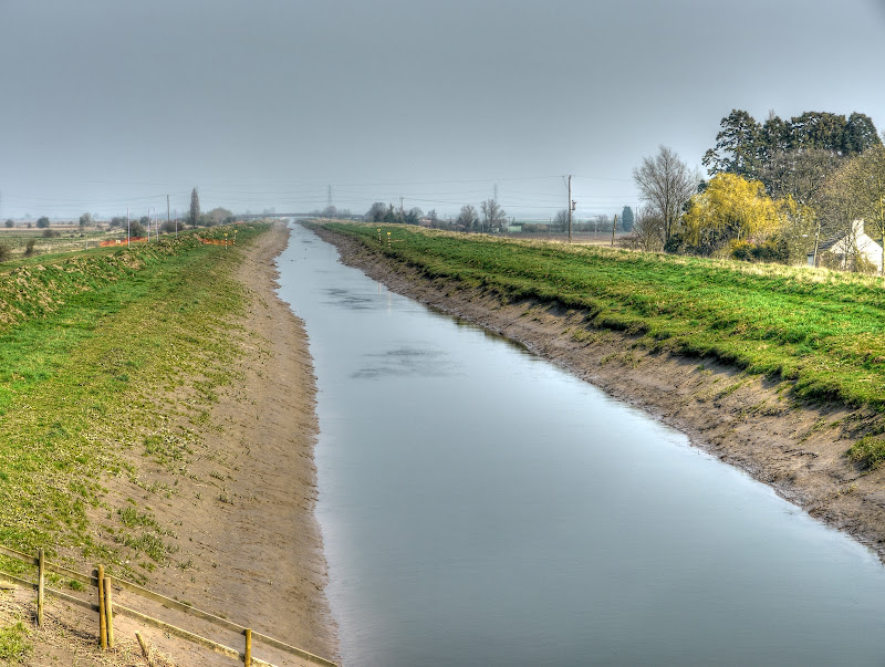
It wasn’t long before I reached the Lakes area on the outskirts of St Ives. This is the bit that is prone to flooding.  Although I can’t help feel that the worst flooding occurs on the maintenance path.  Since the path serves as both a cycle and walking path and an access/maintenance path for the busway are the any requirements on it being clear before buses are allowed to run.  If for instance there was a crash it the path were badly flooded then ambulances/fire engines and police cars would struggle to access the area.

I was surprised that there was still a pretty large puddle, although as you can see you can stick to the path and still get around it.  The gravel on the left is a bit loose though – not nice for cycling along. With any luck the rest of the cycle way will be like this.

At this point there are some lovely views of the lakes area.  For those people commuting from St Ives to Cambridge (or vice versa) it will certainly be a picturesque journey.

The next puddle – yep it looks as if the route is passable now.  Mind you it also looks as if someone has been putting down a load of large gravel  - you have to pick your route when cycling on this stuff – it ain’t pleasant.

What surprises me is that even where there aren’t any particular dips long-term puddles  have formed. They have also been hanging around for months.

It looks like I spoke (well thought really) too soon. This puddle has not yet dried out and is still effectively blocking the path.  I went around to the left, it was ok but gets very muddy when wet.  If you look on the track there is a person walking, another cycling and a dog. Clearly they’re not convinced that path is high-quality.

The path got even worse. The is a long-term long puddle which has left behind some pretty soft sticky mud.  I got past the first one, but took to the bank on the left for the second bit of puddle.  My wheels then sank in and the bike bogged down. I had to get off, heave it out and walk along the bank – not nice when you are wearing sandals. Thanks Mr CCC a high quality cycle path with in built mud-pack treatment. How can it have been possible for this cock-up to occur eh?

In all I saw around 15 cyclists using the CGB route – 2 on the high-quality path and the rest on the concrete tracks.

At St Ives I cycled through into the centre and then looped back onto NCN51 via the London Road and stuck to the route the whole way back to Cambridge. Between Fenstanton and Fen Drayton there are quite a collection of nurseries (plant-growing). I also passed this, as yet, unused Phone Box Gallery.  It looks like it could do with a bit of TLC as well as some art.

Fen Drayton is a picturesque village on the edge of the lakes.  When I was a boy and we were about to embark on a long car journey my parents would buy me and my brother an I-spy book – “I-Spy on a car journey” for instance which encouraged children to look around and spot features – and you get point for them. So you might get points for spotting an AA box or and old style road sign. Which is why this reminds me of the I-spy book – it is just the sort of old-style road sign that you would get a few points for.

Alongside the Fen Drayton nature reserve is a field that had a tall very green crop growing in it. It looked a bit bamboo like, although I am not really sure what it was. Well it has been bailed up – a strange time for baling, but then it isn’t your normal straw.

Such is the power of my newer photo filing system – there is no system except they get lumped under the particular place/destination, this is the field.  The tall green grass to the left of the road is the what it looked like in the Summer last year.

I stopped to take the picture after this and a cyclist came by so I took his picture first. Interesting to see that the CGB cycleway has not lured him away – it kind of tells you something really.

The picture I stopped for; the Windmill, Comms Tower and Water tower.  The first two straddle the route of the CGB. This was also my day for spotting road kill. My wife had mentioned seeing a hare running across a field the day before, today i saw a dead hare, fox and badger all dead by the side of (different) roads.  Humm, not really the way I want to see wildlife.

Talking about bloomin’ drivers, the NCN 51 route goes along a road around Oakington Airfield. This “rat-run” is banned to motor traffic (except for emergency vehicles and according to the Cambridge News piece taxis, mopeds and PSVs.)  I have just had a look at the sign in an old picture – the exceptions are:  “access, buses, taxis, mopeds and invalid carriages”. This picture was taken on the 23rd July 2010.

This time around I stopped briefly for a drink and a few energy giving jelly babies and realised just how bad this no-through road can be. In total there were over 60 cars and vans that used the road. I wonder how many met the exemption conditions. here are a few of the vehicles.

I was amused to see this sign warning drivers that there were going to be Toads crossing that night. To be honest I don’t hold out a great deal of hope for the toads, the motorists really don’t seem to give a toss. Including the 5 whizzing by in this picture.

The other thing that I noticed as I cycled along the shared-use path between Oakington and Girton was that it was a busy cycle commuter route. I passed 20-25 cyclists heading out of Cambridge, all but one were using the road.  Now I can hear some car drivers mumbling on about ungrateful cyclists who should £$%^$ know better.  What it tells me is that those cyclists probably feel safer because they do not have to pass umpteen driveways all where cars are liabilities liable to pop out.

I was alright on the shared-use path though and have to say thoroughly enjoyed my leg-stretcher- roll on Summer.