Saturday, August 31, 2013

Cycling the Water Rail Way (Boston to Lincoln and back) part 1

Thursday, 1st August 2013: It has been a while since I last went on a day bike ride. I do like day trips and have cycled to Kings Lynn (part 1, part 2 & part 3) and Norwich (part 1 & part 2),  more than a few times. I have also been to Ipswich and Cromer – in all cases letting the train take the strain on the way back. I also cycled from Hull to Cambridge over a couple of days, mainly along NCN1 and thoroughly enjoyed that trip. Part of the Hull route route took me along the Water Rail Way from Lincoln to Boston.

My wife and daughter were away for the day so I decided to take the day off and go cycling and reckoned that the Water Rail Way would be rather pleasant, especially as the weather was forecast to be glorious.

My original thought was to catch the train to either Lincoln or Boston and cycle to the other one and get the train back.  A quick check and the train journey between Boston and Cambridge would take 3 hours 21minutes (07:00) train and the return 3 hours and  5m (18:49). both with two changes. The Cambridge to Lincoln train would take 3 hours (1 change) ay 06:57, the return would take 2 hours 31m with two changes.

So rounding things up a one-way cycle trip would take around 6 hours on the train. Whereas to drive to Boston would take around 1 hour and 30minutes. Whilst Boston was closer it would mean that the 3 hours saved travelling could be put to use cycling both ways. So I felt that the best option was to drive to Boston and then cycle up to and back from Boston and drive home again. A shame but whilst direct trains can be pretty fast once you start having to change trains then extra time creeps in.

The other benefit of driving was that I didn’t have to book space for my bike in the car. Or get in and drive it at a specific time, I would still have preferred to let the train take the strain though.

My first mistake was to spend more time programming my GPS with the Water Rail Way route and not any time on the short distance between where I was going to park my car and the start of the route.

It is slightly harder than it looks finding a place to park, there is a website that showed various places to park, in the end though I decided to park in the railway station car park. It wasn’t too expensive and it was fairly close to the route. The car park is on Station Approach and it was easy to find as I had plugged it into the SatNav in the car. I also figured that it would be overlooked and so reasonably secure. It would also mean that if I decided not to cycle back from Lincoln (because of say a mechanical issue) and instead took the train then I would return close by my car.

On the map the route is obvious – on the ground it wasn’t and I headed south, but still found NCN1 and then lost it again on Market Place. I do find that the Sustrans route marking can be somewhat haphazard, particularly in towns.  I did not at first realise that the route went round St Botolph’s. Once you lose a Sustrans route it can be quite hard finding it again, especially when there are one-way streets.

Ah well it is all part of the adventure. I probably ought to mention that my plan was to travel light – I had two bags of jelly babies for emergency rations and two litres of water, I also pre-loaded with water on the way. I was going to buy stuff en-route as my contribution to the local tourist economy. I ended up taking ~150+ pictures so I decided to chop up the Post into a few parts.

There is loads of signage en-route, which give information on the local history and flora and fauna as well as distance information. Also to cut a long story short I cycled there and back – although there are two options between Southrey and Bardney, so used one going ad the other coming back.

Here is the Bike Route Toaster Link (BRT) – which I have shown as starting from the Station car park (Station Approach) . There is a Station Path on the map that might make for a more direct route – but I wasn’t sure if you could cycle down it or not.

The distance, there and back, was 107Km/67miles and if you don’t cycle into the centre of Lincoln is flat. If you do then it gets up to 60m. Although the BRT summary does show a small 15m “hill” on the way out, but not on the way back so I guess that was the out route detour.

There is some useful information on the route – here is a Lincolnshire Council link to the route. With various downloads including a map of the artworks.

All in all I started off around 10am. By the time the skies were blue and the sun was pretty hot. Most of the route follows the shared-use path although there is a section where you follow country roads. It is about one third of the journey, between the B1192 (Langrick Bridge) and Kirkstead Bridge – approximately half-way.  Fortunately most of it does follow the river. I have highlighted that bit in yellow on the map.

When I set of I seemed to be cycling quite fast, oh dear the wind was behind me. I made the most of it though.

Blue skies on the Water Rail Way

The Water Railway – A Cycle route from Boston to Lincoln

Coming soon – part 2…

Friday, August 30, 2013

July–a quick summary

Well having gotten to the end of July it certainly felt like I had been getting more cycle-time.  The weather has been pretty good, according to the Cambridge DTG weather station most of the month has seen high maximum temperatures with peaks over 30oC. There hasn’t been much rain although more is reported than I remember.

So a quick tot-up of distance logged on my Garmin Edge GPS shows a total distance for July of 740Km/462.5miles. (Whereas I cycled  290Km/181m in June.) Over that time I cycled (more than 32Km/20 miles) 18 times.

I have been to Wicken Fen  a few times using various routes, I have also been out along the Cambridgeshire Guided Busway Cycleway CGBC and the Roman Road, I have been up to Ely and down to Great Chesterford and across to Connington. I won’t re-hash all the rides, but out of those the one I enjoyed most was probably the trip to Connington and back. Having said that I do like cycling along the Roman Road.

Wild Poppies in the Fens

Worsted Street – Roman Road from Cambridge to Balsham (and beyond)

Bridleway between Connington and Boxworth

Cambridge in a Pickle

When is local government not local government? – when Ministers get involved.  Apparently “Cambridge is too ‘anti-car’, says Cabinet Minister Eric Pickles”.  The Cambridge News report quotes Mr Pickles as saying:

“Town halls need to ditch their anti-car dogma. Making it easier to park will help support local shops, local jobs and tourism.”

Whilst at the same time we have our locally elected Police and Crime Commissioner, Sir Graham Bright, cracking down on anti-social cycling ahead of a boom in tourism.

I didn’t realise just how much of a tourist attraction it was sitting in a car in congested Cambridge.  One side of our rather disjoint (IMHO) Government is telling us that new roads have to be paid for with tolls (A14 toll road between Huntingdon and Cambridge gets government backing), the other side is telling us to drop the car parking prices so that more cars clog the streets of Cambridge.

So it is fine for the Government to use pricing to allocate scarce resources, but not local councils.

Is this sound-bite politics or punishment because Cambridge City Council can’t see a rational reason for contributing to the A14 upgrade? (Both probably.) Strangely pricing is elitists when it comes to car parking, but not when it comes to using the roads.

So there you have it – the conservative approach – cheap car-parking for all – expensive roads for the rich. But what about those who use buses or bicycles? Apparently the “Bus routes to be cut back in congested Cambridge as new 20mph limit is ’too slow’”. Won’t more cars mean more congestion and even fewer busses? Or is it a case of never mind only rich people with cars are wanted in city centre shopping? Actually here in Cambridge the retailers want buses Mr Pickles.

The strange thing is that Cambridge seems to have acquired an anti-car reputation, yet trust me, the cycling provision has been woefully inadequate for a place where so many cycle to work. There have been some one-off significant investments (Jane Costan BridgeRiverside Bridge, but by and large the cycle infrastructure is piecemeal and always playing catch-up. Why are cycles parked everywhere and anywhere in Cambridge – because the Council has failed to meet demand.  Only now are we seeing more investment in cycle parking.  We have yet to see the provision of appropriate cycle parking at the Cambridge Railway Station – despite the demand from those working and studying in Cambridge.

Cycle Parking – Cambridge


Cycle Parking Cambridge Railway Station

Cycle Parking Cambridge Railway Station

Cycle/Pedestrian Bridge – to the railway Station

Cycle/Pedestrian bridge – Coldhams Lane – Cambridge

Police on bicycles – Cambridge – two abreast

Mr Pickles, people want to cycle to work and tourists want to see an historic city not one clogged by cars. Apparently “over 1,000 pupils a month injured in road accidents near schools”. At the same time we are told tat kids don’t get enough exercise and that we mollycoddle them too much. This says to me that we want fewer cars in our city centres not more. (The Telegraph has a table of the worst cities in the UK for child injuries near schools and here is the AXA Roadsafe Schools Report.)

A few recent headlines from the Cambridge News:

I guess the question in my mind is what is the evidence that Mr Pickle’s assertions are based upon?

Thursday, August 29, 2013

A Visit to the Phone Box Museum–Prickwillow

Sunday, July 28th 2013: Well this will be the last ride of the month, my aim is to venture a little further afield for my next ride. So I thought as I have been more-or-less heading out in different directions I would head out towards Prickwillow and then by on NCN11 from Ely to Lode.

I hadn’t released that the River Great Ouse flowed out towards Prickwillow, it was diverted in 1829-30 and diverted north from Ely. The village was built along the old riverbank and the original channel was ploughed and filled in.

That last link also reports that in the 1920s the draining of the land meant that the was shrinking at 2” (51mm) a year and as the land shrank steps had to be added to reach the doors of the church and some of the local buildings. The link also suggests that B1104 between Isleham and Prickwillow is the most affected by subsidence and the some car passengers report feeling “seasick”.

My plan was to stop by the Phone Box Gallery and see what was on display.

The route I chose was to head out towards Burwell and then through Fordham to Isleham and to enjoy the undulating B1104 to get to Prickwillow. Then I cycled back towards Ely and down NCN11 (and the Lodes Way).  I have shown the journey as a loop from Lode – and no I didn’t drive out – I just think it is easier to show the actual loop. I have met cyclists who do drive and park in Lode in order to be able to cycle along safer routes (their words).

Here is the Bike Route Toaster Link, the loop is a little over 60Km, and flat, with a little ripple in places. Although this route has more road than I would normally use I personally don’t find the B1102 or the B1104 to be too bad. It can get a bit exposed out between Isleham and Prickwillow though. So it is probably worth looking at the weather forecast to check the windspeed and direction. I think I got a wrong although the average windspeed was around 10Knots and from the South. So it certainly helped on my way to Prickwillow and the route back has more shelter.

I do wish there were better ways to tackle speeding in villages rather than random hillocks along the road with cycle lanes hopping on and off the road.  This is Market Street in Fordham. The path alongside the car is a shared-use path according to the map. Then there is an advisory cycle lane on the road then it switches back to the pavement. But a little bit further on it goes back onto the road!

I for one would be more than happy to have my SatNav tell me the speed limit and where I was exceeding it. It would make driving easier not harder. I still think that the driver would be responsible no matter what. Although it has been used as mitigation, and accepted as such it appears in the case of a death of a cyclist. (Here is another case.) I guess the warning would have to audible.

Market Street – Fordham

Here is the map of my ride. I sort of followed NCN51, but didn’t bother going up the hill and round Swaffham Bulbeck. As a cyclist there is a junction to negotiate heading out in either case.

I also didn’t bother with the Reach bypass, nice as it is. Mind you I did avoid the up bit of Mill Hill.  I still had to climb up – but used Rogers Road instead.

A Lode – Prickwillow Loop

I have not thought about it before – but the River Snail goes through Fordham from Snailwell. According to Wikipedia the name means “spring or stream infested with snails” or maybe “sluggish stream”.

After Fordham there is a straight bit of road, towards Isleham.  The road rises over what would have been the Cambridge to Mildenhall Railway line and  part of which is now Isleham Local Nature Reserve (LNR) – a linear site.

Isleham is an interesting fen village. Here is a map c. 1800 of the place  The National Byway passes through as well. A pity it is still under development. After Isleham you join the undulations of the B1140. It is not so busy though, perhaps because it isn’t so smooth, or perhaps because not a lot of traffic travels between Prickwillow and Isleham. I did pass this burnt-out van just off the road though.

Burnt-out Van alongside the B1104

The undulations don’t really register on a bicycle though – well not at the speeds I cycle at.

The road to Prickwillow

As you get nearer to Prickwillow there is a shed in a field – this one in fact – I have taken its picture a few times.

Shed in a field – Prickwillow

Black Wing Drain – Prickwillow

After reaching Prickwillow on Putney Hill Road – although there is not much evidence of a hill – I turned right and onto the Phone Box Gallery.  A while ago the BBC ran a Domesday project – Putney Hill farm gets a mention.  There is also a mention of the Farming Year in Prickwillow.

Here is a link to a talk given by Chris Jakes – Principal Librarian Local Studies, Cambridge Central Library. He grew up in Prickwillow and shows many interesting pictures, including the Soham Train explosion during the war and a 1576 Saxton map with the River Great Ouse passing Prickwillow.

Here is what I came to see – it was publicising Open Studios. The last exhibition on their website is for Jan 13 – Barbara Dunaj.

Phone Box Gallery - Prickwillow

This is what crash test dummies do on their days off?

Phone Box Gallery - Prickwillow

I then headed home. I was concerned that there was rain around and did fell a few sprinkles – although Cambridge didn’t get any in the afternoon. Anyway I didn’t hang around just in case. My first stop was Burwell Lode Bridge.

Burwell Lode

When I reached Newnham Drove there definitely seemed to be rain to the North- I seemed to be heading away from it though.

Burwell Fen Farm - Newnham Drove – Lodes Way

I was convinced there was rain around and I didn’t have a rain jacket of warmer top – so I kept going.

Raining near Upware?

As I got closer to home I was sure it had rained but I’d managed to escape it. Mind you a quick look at an Ely weather site suggests no rain there!

Dark Clouds above the Fens

Although it is not a route I take that often it does make for a good leg stretcher.

A Pickle of Politicians

It seems to me that the Evidence-based policy making is what you tell other people they should be doing – but when it comes to the Government that happens to be in power it all seems to come down to “sound-bite policy” making.

Eric Pickles (communities Secretary)  wants Local Authorities to ensure their their parking rules aim to rejuvenate high streets, rather than raising revenue from ‘penalising’ drivers. Or as it was reported in the Telegraph – Eric Pickles attacks councils putting motorists off high streets.

Hum, I wonder what evidence this is based on?  Where will this extra parking come from? I see the problem in Cambridge as being one of congestion not car parking charges. In any case I prefer shopping for lots of stuff over the Internet. I get a better choice and price and it is a damn sight more convenient as I can do it in my pyjamas at the end of the day.

So I think that we need to understand what is cause and what is effect and what is the evidence to support the changes he wants to make. Do we really want to make City Centres more car friendly, surely that will just make them far less people-friendly and slow down all the traffic even more. It will also make it even more unpleasant and difficult for the residents around the city centre.

Apparently one concern is that out-of-town shopping centres  have also caused problems for city centres. That might just be because the cars are kept away from the shops – certainly the ones I have been to such as CMK (Milton Keynes) works because there are a load of shops and no cars. Also those out of town shopping areas tend to be near large roads and road networks. So will Mr Pickles (or the Rt. Hon.) also require that Councils build motorways direct into cities?

Perhaps we ought to close down the Internet as well.

Talking about research, well Transport for London found that the per visit spend of a cyclist was £21 versus that of a car of £41,  but the spend per week was £47 for a cyclist versus £56 for a car. People walking spent the most per week as it happens - £93. It also turns out that there is a switch from car use to other forms of transport. Other studies have shown that cyclists and walkers can end up spending more each month.

Actually I wouldn’t mind seeing the removal of speed cushions (another suggestion apparently)  – but the enforcement of speed limits is more important where there is a mix of pedestrians, cyclists and traffic I would have thought. So will the Police still say that enforcing speed limits is ‘unpractical’ where such traffic calming measures have been used and then removed?

I know that Cambridge isn’t representative of all places but the Police have had to step in as “parking battle erupts in Cambridge”.  We also have Cambridge residents with ‘oversold’ parking permits battling for parking bays.  They end up driving around for hours apparently! We also have illegal parking in disabled bays – which has to be a pretty selfish and low thing to do.

Strangely at the same time grants are available to “get employees out of their cars” for companies along the routes of the A14 and A10. So shoppers in cars are welcome but not workers! Mind you if you don’t drive to work then you lose the opportunity to make £20 a day renting out your driveway. Mind you the top places for renting out drives are Manchester and Edinburgh.

You’d think that if it was so bad there would be loads of complaints about traffic wardens – well in Cambridge there have only been 10 complaints in 2 years.  The problem is one of congestion making it easier to use sustainable transport does seem to be the answer. (This Post from David Hembrow explains what a pickle we have gotten into.)

I wonder how these plans to make City Centres more attractive to motorists will affect the road accident statistics for 2012 in Great Britain:  -  420 pedestrian deaths, 5,559 seriously injured pedestrians, 118 pedal cyclists killed and 3,222 cyclist seriously injured. Accidents like this reported on Oxford Street London – a popular place to shop.

At the same time we Mr Pickles wanting an easing of the restriction on motorists in City Centres we also have more restrictions being introduced including on-the-spot fines for tail-gating and lane-hogging coming into force. I am in favour of safer roads and the next time you are in are near a busy road check out how many vehicles tail-gate it is frightening, it makes me wonder why there aren’t more accidents. Police will also be able to offer Educational training which seems to me to be a better approach. I wonder when more driver monitoring will become acceptable. Certainly I would advocate it for the people who transgress.

Cut traffic Improve shopping

The trouble is whilst this approach might actually make the roads safer and reduce congestion by smoothing traffic flow and cutting accidents it is difficult to accept politically. It fails the sound bite test and yet we have monitoring of offenders?

Apparently the Minister for More Roads or Transport Minister as the Government call him, Norman Baker visited Cambridge for a tour and what looks like a photo-op and half-hearted reassurances that the Coalition was “positive” about cycling.

I seemed to remember a while back that Governments wanted joined-up thinking.  Well less of the sound-bite/photo-op, more consideration of the evidence and more joined up thinking please – or rather joined up policies from the different departments.

Did you know that “One in five strays no more than 500m from their car!” Phew what with Internet shopping and hyper-car dependency no wonder we have problems with obesity here in the UK. Half of seven-years olds are not getting enough exercise – roads for cars is not the answer – roads for bikes is.

Kids just wanna have fun

Be careful what you wish for – you might get it – “The world’s coolest car parks”.

Monday, August 26, 2013

Cambridge–Connington Loop–epic mainly not-road near Cambridge

Friday, 26th July 2013: For choice, when I go cycling I like go through the countryside, as rugged as possible and as far from motor vehicles and buildings as possible (and pylons). I  also prefer not to have to travel a long way to get there.  I am also not that keen on long hills – I prefer rolling countryside. I also accept that pretty much all of the countryside in the UK has been altered in some way or other.

For instance the Fens are not the swamps they used to be, the Lake District has been a “park” for a long time. I quite like cycling through farmed countryside and I really like cycling through woodland and grassland.

Of course my rules of cycling also come into play.  I prefer to cycle a loop rather than there and back by the same route. If the route has some rugged aspects – e.g. corrugated mud tracks then I prefer them to be on the first half of the ride rather than on the way back. I also prefer to cycle out into the wind and back with the assistance of the wind.

Whilst I claim to be an all-weather cyclist I do find that I cycle more when the weather is sunny and warm. I claim it is because it makes the byways and bridleways easier and less muddy. (Or maybe I am just getting older!)

I also like to explore new routes, but here is one of my more “epic” routes around Cambridgeshire.  It isn’t actually that far, just under 40miles (62Km), however quite a lot of it is away from road. It doesn’t reach great heights (40m) however you do find a little bit of rolling countryside around. What it does do is take you where cars (and other motor vehicles) can't go.

This route is a little longer than necessary and could easily be shortened. The best bits are heading out along the Cambridge Guided Busway Cycleway (CGBC) and coming back via the bridleways from Connington to Dry Drayton.  The CGBC could do with a name really, cf. The Lodes Way. How about Slepe Way, the route runs out to St Ives which was called Slepe until 1,001/2.

However I wanted to re-visit the Butt Lane with its half-finished cycleway. At least the exercise of cycling along it would balance out the increase in blood pressure I suffer when I think about how dreadful the planning and implementation of that cycle route has been. (See Butt Lane – butt cycleway for my recent thoughts.)

So to start it off I enjoyed a pleasant detour out to Quy and then back through the fields to Horningsea and then up to Clayhithe and then back alongside the River Cam.  The River Cam tow path forms an NCN11 stubs. It is a great leisure route to nowhere in that the cycle route stops at Waterbeach. If you want to take NCN11 to Ely then you have to use NCN51 – obvious isn’t it. The map shows a dotted line route – that is not some code for off-road that means it aint sorted yet and has it has been incomplete for a long time probably never will be.

The NCN 11 route alongside the Cam is very pleasant although the path is not very wide and it might be a bit trickier in the dark. I usually leave the tow path at Milton and then cut along to Butt Lane. This route was intended to be a way for schoolchildren to get from the village of Milton to Impington Village College. It caused an uproar because of the potential loss of the free school bus. (Normally free school buses are only supplied where the distance is greater than 3 miles, however this route (pre-cycle way) was deemed dangerous (I agree) and so the bus was free. Apparently over 200 pupils use it!

The plan was for a 2.5m wide cycle path with a 0.5m gap (as noted on A View from the Cycle Path). To be fair to the villagers in Milton although some concerns just seem to be about losing the free bus, others point out issues with the planned route. Although it does say they would only support the cycleway if there  were cast iron assurances about the bus.

It seems that progress is being made – although I am not sure that progress is the right term. At the moment there is a purpose-built shared use path (oxymoron) that goes part way from Impington. There is also a footpath at the other end that passes the entrance to the P&R and the Recycling Centre.

Well I have some good news for the residents of Milton, I reckon their school bus service is safe. I don’t think that new bit of the shared-use path is safe, nor is it designed to DoT standards – Shared Use Routes for Pedestrians and Cyclists and Cycle Infrastructure Design. It is not wide enough, nor is there enough gap to the road. I think the road has a 50mph speed limit.  Well Page 16 of the second document recommends a width of 5.05m where Buses/HGVs pass at 30mph.

The same document also talks about the dynamic width of a bicycle (Figure 2.2) and the distance a bicycle should be away from kerbs (0.5m) and continuous features (1m)/ They cite walls and railings, but I reckon hedges fit that bill as well.

This is where Butt Lane passes the Business Park.  I would hope that the priority would lie with the cycle path. Particularly as the young teenagers are undergoing further brain development and are prone to taking more risks. You will also note that the path is right next to the road. Now my handlebars are 65cm wide – which means my handlebars would have a significant overhang on the road if I were to cycle close to the kerb.

Butt Lane – Butt Cycleway

Here is the map of my route and here is the Bike Route Toaster Link.

A Cambridge – Connington Loop

Here is the old stretch of the shared-use path. I must remember to take a tape-measure – it doesn’t look very wide. Although there is a wider gap to the road. Unfortunately this bit of the path is booby-trapped. The path is right next to the hedge and brambles hang over. Perhaps cyclists will have to wear safety goggles when they cycle so they don’t get their eyes scratched out.

I once had to get into London early and so cycled to the station when it was still dark. My front light was set to illuminate the road/path surface ahead and I was raked by brambles. I got a strange look when I bought my ticket – when I popped into the gents I could see why. My face had streaks of blood.

 Butt Lane – Butt Cycleway – Butt Brambles

The trouble is shared-use paths suffer from lack of maintenance (and poor design) because pedestrians are also seen as second class citizens. Having passed through Histon I reached Park Lane. This is the shared use bit just on the outskirts of the village. There are protruding brambles and overhanging branches. The path is very narrow – still at least there is a wider gap to the road.

Park lane – Shared Use Path, Histon

After that it was a pleasure to reach the CGBC or Slepe Cycleway. Alright there are buses that go by, but they aren’t that noisy and they do whizz by pretty quickly. At the moment, after Histon the route passes through farmers’ fields and the Fen Drayton RSPB Reserve.  Mind you in the mindless rush to build more houses in the area  (Bourn) we do have a pending village/town – Northstowe which will take away some of that view.

The strange thing is that we are told that we need lots and lots of houses – but despite Northstowe planning submissions being made in 2007, eight years later nothing much has happened. Why? well perhaps because the developers didn’t think they could sell the houses. The lack of progress on the A14 road improvement scheme was used as a an excuse reason as well.

Potatoes growing alongside the CGB Cycleway

Looking at the cycleway alongside the CGB it looks pretty good eh – wide, smooth tarmac,  solar powered lights along each side. Mind you the original scheme did not include a tarmac surface beyond Swavesey. Fortunately a charity stepped in with £150,000.   It also still floods quite a lot at the St Ives end. The cycleway not the busway.

So even in a cycling city cyclists get the leftovers. Mind you the development was fraught and there is still a dispute between the County Council and the Contractors.  The good news is that the Busway seems to be doing well with the busway carrying over 3m passengers in its second year of operation.  (>8,200 per day, 7 days a week.).

Cambridgeshire Guided Busway – Cycleway

I like the CGBC as it is a pleasant and fast route to other places and it is fairly long and not interrupted by junctions too often. From Milton Road,  Cambridge to Harrison Way, St Ives the cycleway is a little under 20Km (12 miles) and around 6 junctions.

I turned off before St Ives at the Fen Drayton Lakes, down Holywell Ferry Road and through Fen Drayton.  Although it is called a road it is really a pot-holed gravel track. After Fen Drayton you can choose this bit of shared-used pavement alongside Mill Road. Pavement with paint really and too much of it. This stretch of path has 12 give-ways along it. It is 0.88Km or a little over half a mile.  That is pretty awful. What is the legal position for pedestrians do they have to give way? Check out Highway Code rule 206 (it has many bullet points this is one.)

Drive carefully and slowly when

  • needing to cross a pavement or cycle track; for example, to reach or leave a driveway. Give way to pedestrians and cyclists on the pavement

Well that clears that up – not.

Shared-use path – 12 give-ways in half a mile – Mill Road, Fen Drayton

After negotiating the speed bumps along the High St in Fenstanton  you have to turn left down Hilton Road. This road only works as Hilton Road for pedestrians, cyclists and horse riders since there appear to be bridleway rights. Mind you you have to go down a narrow tunnel under the A14 and negotiate some pretty tight bends. I reckon you’d have to get of the horse. Then you reach Hilton Road, although on Streetmap (25k) it has been renamed Hilton Road!

Then there is a pleasant run down to a bridleway of the Elsworth Road.  Then, until you get to Dry Drayton it is mainly fields. It is not totally obvious quite where the path is – although there are gates along the way. The second field along (I think) I cycled through a field of sheep. I did my best not to disturb them and they didn’t seem to bothered by me bumping along.

Spot the bridleway in this field of sheep near Connington

There weren’t any cows in the field I was in, although I could hear some nearby. A little more care is needed then – but I have never really had any problems. I have been chased many times by dogs though! Talking about cows a man was trampled by cows near St Neots and is seriously ill in hospital (Addenbrookes) – that is quite close by.

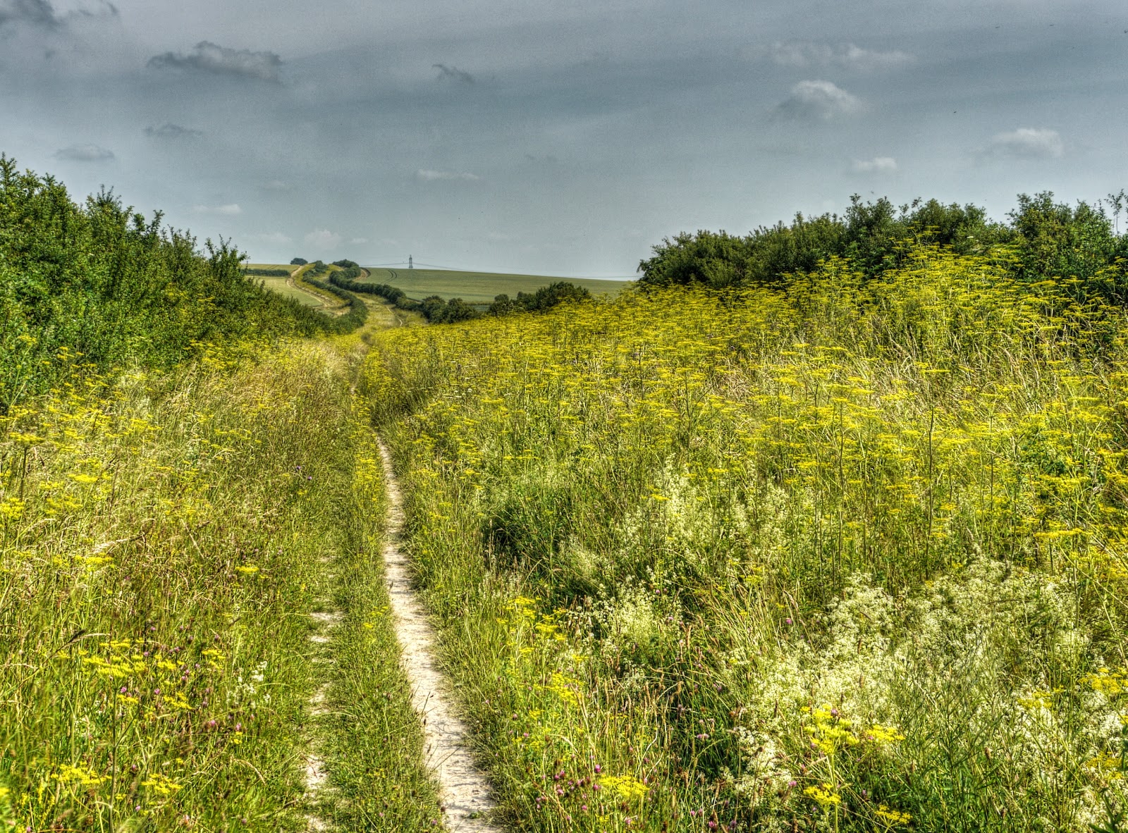
Although the bridleway runs in parallel with the A14 you don’t really hear much. Some of the fields have crops growing in them – there are wide field margins though. This bit of the countryside is also a bit more rolling – hum, be careful what you wish for. Climbing on grass can be a bit more energy sapping.

Bridleway between Connington and Boxworth

Alright the hills are not that big – it gets up around 40m above sea level.

Bridleway between Connington and Boxworth

Once you are there the views are good.

Bridleway between Connington and Boxworth

It was a Friday and it looked like lots of motorists had flooded onto the A14. According to the OSM map this bit was closer to 50m above sea level. It is where the bridleway jinks. If you zoom in you can see in the near ground the Boxworth Lorry park and more distantly a church spire in Fen Drayton (St Mary) and a church tower (St Andrews) in Swavesey. According to the Cambridge News there is an issue with the ”sex trade” at the Lorry Stop.

View from the Bridleway between Connington and Boxworth

The same aspect, but much less zoom.

The Bridleway between Connington and Boxworth

Looking back the way I had come – alright I will come clean – it was a fair haul on the soft grass and I needed a breather.

The Bridleway between Connington and Boxworth

Looking back I noticed some wind turbines – these things seem to be popping up all over the place. If you look at the picture closely (or enlarged) you can see how the heat haze has made the columns look wiggly – either that or they are a new type of design.

The OS and OSM maps don’t actually show this development.  I think that it is Cotton Farm according to this map, near to Gravely. It is shown as under construction. It appears on this link – Cotton Farm Action Group with 8 turbines so it matches the picture.  The Google Satellite picture shows what looks like an old airfield.  It is producing energy. Why is it Wind Farms quote the number of homes – in this case approx. 10,000 homes.

The Website does mention it is on the site of a World War II airfieldRAF Gravelysome pictures.

Cotton Farm Wind Farm – (on the site of RAF Gravely

You roll down and the up from Boxworth to Lolworth and then I take what is strictly a footpath from Lolworth to Bar Hill. Yes the track rolls down – then you have to roll up around Bar Hill. There were a couple of inquisitive, small and yappy dogs – more inquisitive than anything really.

I suppose I could have cycled along the A14 and maybe got some words of advice from the Police like this Rickshaw cyclist, they did point out he was not committing an offence.

Footpath from Lolworth to Bar Hill

After that I climbed up again to Dry Drayton squeezing through the various Gandalf Gates (“You shall not pass”) that block the way for all but thin travellers. Then it was rolling road into Cambridge Although I did stop to take a picture of the bit where the M11 meets the A14 – lots of cars with one person in them!

Friday afternoon queuing – approaching the Girton Interchange

So there you are – I rather like the ride – when the going is good – you cover some distance, see some countryside and climb a few small hills to boot and mainly not-road

Saturday, August 24, 2013

Kingfishers Bridge

Wednesday, 24th J8uly 2013: I think this will have to be another word-lite post, otherwise I will never catch up. I am still a month behind – although on the bright side I have really enjoyed getting out and about over the last two months.

The weather during the Summer tends to be pretty dry here in the Flatlands which makes the byways and bridleways generally OK dry and solid,which apart form the ruts makes then good places to explore. 

So for a change, decided whilst on my default route round Wicken Fen I decided to visit Kingfishers Bridge, a nature reserve up on Dimmock’s Cote Road, next to the River Cam. Although I didn’t actually take any pictures of the area itself. There is a byway that passes it to the right and one that passes it to the left. The one on the left just seems to turn into a footpath though. Which seems a little odd. The 1930s map shows more promising tracks – but they don’t seem to have bequeathed rights of way to the farm tracks that now exist.

So I tend to cycle along to the right and the Car Park is on the way out and so it does not encourage me to stop and take pictures.

I often stop on the Swaffham Bulbeck Lode Bridge though (part of Lodes Way)..

A family of Swans on Swaffham Bulbeck Lode

Although I could have used other collective nouns. A bevy, or drift or sownder or team, to name but a few.

A Drift of Swans on Swaffham Bulbeck Lode

I turned of Lodes Way up to Upware along Great Drove.  Only one vehicle passed me up to Kingfishers Bridge. Where the road turns a corner I stopped to admire some irrigation in operation.  Whilst look at the OSM map I noticed that there is a nearby marina – Tip Tree Marina – I must check it out.

Irrigation along Great Drove

The only downside to the route is that I had to cycle a short distance along the A1123, quite a busy road. To turn right I went left onto Fodderfen Drove and then crossed the road with a clear view both ways. I would normally turn right form the road – but life is short enough. If you follow Fodderfen Drove south it is another byway that turns into a footpath. Which does not seem at all logical to me. Unless it was a route to a dock on the river?

A common feature of byways – telegraph poles.

Fodderfen Drove – looking towards Kingfishers Bridge

After a short way you reach the reserve. Apparently it was started in 1995 when 300 acres of arable farmland was transformed into  “a mosaic of wildlife habitats”. It was the work of a farmer – Andrew Green.

I do remember that the reserve came up for sale a couple of years ago through Savills, with an asking price of £2.3m. It appears to have a runway in the area as well. The website still shows Andrew Green as one of the contacts, so perhaps it was not sold after all? The website has a gallery of pictures.  The nearby house was also up for sale, along with a grass airstrip, 10-odd acres of grazing meadow and 6-odd acres of woodland.

Kingfishers Bridge – Information Board

I then cycled along Shaw’s Drove and joined NCN11 and headed by via Wicken Fen and Lodes Way. I passed Docking’s Lane – which is the route I normally use when coming up from Upware.

Docking’s Lane (the track to the left)

The recently pollarded trees are an odd sight alongside the Burwell Lode footbridge.

Burwell Lode Footbridge

Although this is a footbridge it is also on the route of the Lodes Way. As you can see it is quite steep and to get over the Lode you have to carry your bike or push it up a metal channel. It isn’t that easy, it is worth it though.

Cyclist pushing his bike up over the Burwell Lode Footbridge