
Monday, 18th April: At the risk of repetition I will say it again. One of the advantages of working from home is that you save a lot of commuting time that would be otherwise be very constraining in terms of use of time. I would and do cycle to meetings but you generally have to go to a particular place. I could hardly suggest a meeting location which depended upon the weather and where I felt like cycling to that day! Although commuting does have its advantages as well – it provide you with a reason to get out and ride twice a day and like a lot of cyclists when the whim took me I would sometimes use a long-cut either getting to or from work. That can be either a great way to prepare for the day or unwind at the end of the day. It does not quite beat a cold beer at the end of a ride on a hot summer’s day but it is pretty close.
I suppose really it just means that you can make the best of whatever circumstances you are in. When I was commuting to London two days a week I got to ride around London on my Brompton, which was quite an education – interesting places were much closer than I had realised.
However I don’t commute and with the lighter evenings and mornings I find it easier to get up and get things done and then find myself with a couple of hours to spare at the end of the day and yet the weather is still pleasant and light. I needed some thinking time today and so planned my route around two substantial byways. Actually I was originally planning to cycle out along Lodes Way but felt like a change. This is the route – out along the Roman Road to Balsham and then across to Dullingham (part Byway part road). After that I cycled along to Swaffham Bulbeck and back to Cambridge on the NCN51. Here is the map and here is the Bike Route Toaster link, it is not so much a loop as a square. The length is 53Km / 33 miles and actually reaches the dizzy elevation of 111m.
There is an early hill or two as well.
Actually I should mention that I have to fix a puncture before setting off. The rear tyre was flat and when I tried pumping it up it went down immediately. A closer look and there was a cut across the tyre and into the sidewall and a corresponding cut along the edge of the inner tube by the seam. I had a look around the tyre and it was fairly worn with quite a few cuts and the tread was also visibly worn as well. One of the downsides of cycling along the byways and bridleways is that it does take it out of the tyres. Mind you I think that cut was actually some glass that I had ridden through the day before around the mean streets and cycle ways of Cambridge the day before. Although I am not sure why it did not deflate as I was riding? whatever it was might have gotten lodged in the tyre. Anyway I replaced both the tyre and inner tube. The tyre needed replacing, it is surprising I have not had more punctures it was so cut up and as the tube had a slit in it and along a seam I replaced that as well.

With the recent spell of warmer weather the countryside seems to be turning very lush and loads of wild plants have sprung into action. This is the Airport Cycleway (according to the OSM Cycle map), although that makes it sound grander than it is. This is not a busy airport although it is looking to develop regional ‘city hop’ routes. You do get a few plane spotters from time to time. What did amaze me is how the Cow Parsley has grown so quickly. The Wikipedia link does warn you not to relay on their identification, which is even more true of my identifications. I have known it as Cow Parsley since growing up in Somerset – but it might actually be something else. whatever it is is has shot up along with the rest of the verge vegetation.

For some reason, I headed out up Lime Kiln Road, a very narrow road up a steep (well for these parts) hill reaching 45m and a pretty good view over Cambridge. This road can be a bit of a rat run during the rush hour and it also would seem to be the scene of quite a few games of chicken. As I cycled up I did find that I was given space by the motorists, but they didn’t give each other enough space sometimes. I counted nearly 30 smashed door mirrors along the side of the road. Fortunately I did not puncture (famous last words).
I then turned up Wort’s Causeway (in the direction of Fulbourn towards the Roman Road. Yet another hill to climb – this one reaches all of 68m, mind you the previous hill goes down before getting to this one (to around 25m). The good news – well for me anyway is that hill climbing is getting easier again. My legs must be getting fitter as unfortunately I am certainly not getting thinner.
There is a scruffy unofficial layby where you leave the road to join the Roman Road (byway) or Worsted Street as it is more properly known. There is a metal gate with a narrow gap which I had assumed was to discourage car drivers but be wide enough for double-buggies and mobility scooters. It is just wide enough that you do see cars squeeze through and then the occupant just seems to sit there. All a bit odd if you ask me.
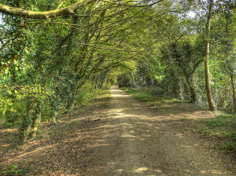
Not long after cycling along the Roman Road is the delightful avenue of Beech Trees arching across – at this time if years the leaves are a fresh green and the sunlight dapples the path below.
There is notice board not much further along, put there by the Friend of the Roman Road (www.frrd.org.uk) showing a rather nice circular walk which returns via Fleam Dyke.

The Roman Road passes Wandlebury Ring and there are routes to the Ring (both footpaths and byways). When you get past the Wandlebury area the path opens out a little – or rather you done have such large trees on both side. The path itself has hedgerows pretty much each side all the way to Balsham. In this dry weather there are two or three “ruts” to choose from to cycle along.

The Roman Road crosses the A11 at Worsted Lodge with a bridge that also serves the farms and garage also located here. The bridge is only wide enough for one vehicle, mind you I don’t think I have ever seen a car using it. The A11 was busy but not jam-packed.

The great thing about this route is that very quickly you forget all about the busy roads and you feel like your back in the peaceful countryside. Of course that might also because I was listening to my MP3 player and so couldn't here the distant traffic anyway. It was a lovely day though, blue skies, sun and the occasional fluffy white cloud.

It does seem like there are yellow fields all over the place though. This picture was taken looking along the line of two trees in the last picture. A nice uniform flowering.

Gunner’s Hall lies up near those trees on the left of the picture. This is actually three pictures stitched together and was a huge field on a slight slope rising from 70m above sea level (where I was standing to around 90m at the edge of the field).

The character of the path does vary as you travel along it. At points it gets somewhat thinner, still with hedgerow on each side. As it gets thinner then the effect of concentrating the traffic on the path causes the mud ruts to become more obvious. Mind you since the traffic is only walkers, cyclists and I presume horse riders then the damage is not great. Whilst I usually see someone on the Roman Road I have never seen it very busy. Today I saw a few walkers and two cyclists.

As the title suggests there are also a lot of yellow fields alongside the Roman Road at the moment. This is yet another picture made up of several stitched together. (The last one was 3 this is 2 side by side.) Apart from the odd wood the yellow goes almost as far as the eye can see. This picture is of Balsham Wood (an SSSI) and was taken after turning off from the Roman Road and off another byway towards Balsham (at this point it is shared between the Icknield Way and the Harcamlow Way).

This is the tree in the centre of the last picture in front of Balsham Wood. The last picture was at minimum zoom and effectively wider because it is two pictures – this is that tree but zoomed in. Despite the yellow being so bright the tree does not actually stand out as much as you (well I) might think.

The same tree but with a zoom somewhere in the middle. It must be time to move on a little.

Well I made it another 0.5Km up the path and stopped to take this picture looking towards Balsham. The first bit of the track where it leaves the Roman Road is quite bumpy and ridged. It is well used by the farmers I would imagine as you get closer to Balsham the track surface is much flatter although you have to watch out for the odd pothole. It is only when you get much nearer to Balsham does it have a tarmac surface.

You come out near a village ship and then cycle down the High Street before turning right onto Fox Road. While looking to see what the history of Fox Road might be I came across the Balsham Ploughmen, who raise money for charities in and around Balsham on Plough Monday. Fox Road quickly leads onto a byway shown almost as a road on the OS map. It has sides a lot of its length, mainly hedgerow. Yet again there are fields all around that had seemingly turned yellow overnight.

This byway is quite well rutted in places and I was surprised to see a Traveller caravan a little way along it – mind you I think the kids playing were perhaps more surprised to see me rattling through the potholes.
As you can see here the path is well delineated, but not by hedgerow all the time. It is presumably quite an old route. I was taught that the the deeper the path compared with the land around then the old the path. I generally cycle along the middle track – the outher trakcs occasionally get quite deep and you risk pedal banging.

It looks like the farmer has a bit of a problem with yield here, either that or some ham-fisted alien who has not yet learnt how to make a proper crop circle. Not being an agricultural specialist I have no idea what caused the non-yellow patch. The plants don’t seem to be growing very strongly at that point (disk).

This is the byway looking back down the hill, did I mention that it undulates a bit round here. This bit has hedgerows and moderate ruts.

The view of the byway to come, it is undulating uphill and narrows a bit which means you have to be a bit more choosy about which path you follow when cycling along it.

After carrying on along the byway past a couple of roads and a pumping station you join a road. Mind you the bit by the pumping station is downhill, but very bumpy. The road is called Grange Road and carries on the earlier habit of undulating. For choice I prefer countryside like this to cycle through. The hills don’t tend to be large and it is not long before you are rewarded with a bit of downhill and if you keep your speed up you get some assistance climbing up the other side.

Grange Road does cross a more important road so you can’t just keep bowling along. You have to stop near the bottom of an undulation. There are of course more yellow fields around. This is a view of Grange road again.

As there was no boundary between me and the yellow fields I couldn’t help stopping to take some pictures of tracks in the fields – here is one leading off into the blue-ish sky.

Another track – this time leading to a tree. The tracks a regularly spaced across the field and are where the farmer drives his tractor to spray and fertilise I believe.

Yet another tree in a sea of yellow.

Grange Road becomes Balsham lane as you reach Dullingham. I have just noticed a place called Jack’s Gallows near Deerfield Farm, just off Balsham Lane but can’t find a reference on the web.
I did pass some different yellow flowers in the verge – neither Oilseed Rape nor dandelions. I think they are Leopard’s Bane or Doronicum orientale and not strictly a wild flower.

I think that this is Greater Stitchwort (Stellaria holostea). Apparently the name derives from an ancient herbal use to relieve a “stitch”- a sharp pain under the ribcage.

At least there was one plant I knew without having to check – the Common or English bluebell. (Hyacinthoides non-scripta). All these flowers were growing along the same stretch of grass verge, although the bluebells were set a bit further back in the hedgerow.

When I got home I noticed that Garmin have released a new version of the Garmin Training Center (US spelling) – so I thought I would update that before uploading the ride from my GPS. It took a little longer than I had anticipated. They have modified the format of the database used to hold the stored ride data. So after installing the software it then converts the old data into the new format.
It was well worthwhile, the old version would take 10minutes to close down, this one takes 10 seconds. Whoever wrote the old software used a brute force method to store the data and seemed to load it into memory all at once. Consequently it took heaps of memory to run. In fact I would sometimes have to close other applications to make it easer for GTC to close. That is all a thing of the past. Apparently the new format is also “open”. The only snag was that it seemed to lose my old data – it hadn’t, it was stored elsewhere.
On Monday I had a family ride around Wicken Fen, Lode and Reach (got there by car), and by Coincidence I then also cycled back to Balsham along the via Wilbrahams and the Roman Road and Woodhall lane.
ReplyDeleteGreat minds think alike. The Roman Road is good though - some hills, pretty reasonable track and a little bit of singletrack and quiet... A pity those Romans didn't build a few more. :-)
ReplyDelete