
As I was going to be spending some time in the US on business I decided to go for a longer ride on Friday (the flight out was on Saturday - cheaper tickets!). After checking the wind direction I had planned to cycle to St Ives and then wend my way up to Kings Lynn and then catch a train back. According to the BBC Weather information I would have the wind behind me for the route from St Ives up to Kings Lynn. I had not checked the distance though and the weather forecast also suggested rain showers - so instead of plotting a map and printing it out I decided to be a bit more flexible and see what lay ahead.
I was originally going to take the Sustrans 51 (non CGB route) but in the end after seeing some press suggesting that there might be further Cambridge Guided Busway delays (CBG delays) thought I would pop up the CGB way and see how much work was taking place and whether the route was finally passable by bicycle without resorting to cycling along the concrete tracks.
I also happened (deliberately) along the Sustrans 51 route between Cambridge and Bottisham, it seems that the potholes along the Quy Mill Hotel road near the A14 have been filled. The Cambridge Cycling Campaign run a cycle ride from Cambridge through to Reach Fair on May day (May 1st) am I being to cynical to think that might be why the potholes got filled. To be fair there is quite a bit of work around Cambridgeshire at the moment that is beneficial to cyclists so I should not be too harsh - it is great to see - lets hope it does the job and gets more people out of their cars and onto their bikes and enjoying a bit of fresh air.
Here is the road to the Quy Mill Hotel which helps cyclists bypass the Newmarket Road/A14 intersection. One of the biggest potholes has been filled. This one was definitely a trap for the unwary. Mind you I would always take this "off-road" route rather than take the Intersection route. I don't think I have cycled along the road way for years.
See the clouds in the sky - they definitely looked as if there could be rain - lets hope the weather forecast was correct and it was showers and not rain.

One feature of the CGB is the way it deals with the various roads that cross it. Apart from a bridge under the A14 and one near the Windmill/Communication tower under the Over to Longstanton road the rest of the time there are light-controlled crossings. Such as the one shown in the picture. The cyclist/pedestrian.horse route has barriers, large enough I would hope for cyclists (towing trailers/tandems etc) and horses - but small enough to stop cars finding their way onto the path. I would imagine that another justification for the barriers is that it prevents cyclists from speeding across the roads. The crossings do appear to have sensors mounted on top of the posts - but at the moment they do not seem to influence the lights at all. I also found that the lights were slow to change when the buttons were pushed - in the case of the crossing near Longstanton/Willingham I gave up waiting for the lights and crossed during a gap in the traffic.
Next time I cycle along the CGB I must check to see how maintenance vehicles will "get around" the barriers, it is not that clear in the picture - I assume the barriers will rotate out of the way? The sign prohibiting motor vehicles seems to be partially obscured by the post with the light control switches. See how there are a set of buttons at horse-rider height.
During my ride up the CGB I did seem a few groups of workers - but also noticed an inspection team near the Milton Road end of the CGB, they seemed to be looking at the vegetation alongside the CGB. There are gardens adjacent to the CGB and some of their tees overhang a little - at one point the CGB tracks do seem quite close to the overhanging trees.

Although the weather forecast indicated showers, so far so good, the clouds looked less threatening than they had in Cambridge. The bus passengers will have some pleasant views across the Cambridgeshire countryside.

A closeup of the maintenance track along which cyclists, walkers and horses will also be allowed. At the moment it is being compacted by the maintenance vehicles - I cycled in the left "rut" which was pretty good. I noticed some pitting (mini-potholes) where the CGB goes around the Oakington Immigration Centre though - my concern is that the pits will get bigger and never get fixed so the track will deteriorate significantly and then it becomes much less pleasant to cycle on, especially in the dark.

The track also switches the side it runs along as it crosses roads - not every time, but occasionally. At the crossing near Swavesey the crossing splits into two tracks - one for horses/riders and I assume cyclists, the other track is for walkers. I don't refer to them as pedestrians - I think walkers is more apt description. I wonder why the decision was made to make this crossing different to the others - are more horse and riders expected, or perhaps more walkers. It does look as if it might actually cause uncertainty - cyclists tend to take the path the maintains momentum.

This is how the Swavesey stop looks at the moment. It seems finished, the ticket machine is protected by some wood - but I have seen one in the open and it looked ready to sell tickets.
The building in the background is the MG Owners Club HQ.

Look at all these bike racks lined up and ready to encourage more people to cycle and ride (rather than park and ride). Let's hope that there is a good uptake for regular cyclists. I must check the next time I visit to see whether the CCTV covers the bike racks.

After St Ives, I changed my mind and decided rather than cycle over to Kings Lynn that I would head over to Ely and then cycle back to Cambridge - although it broke the golden rule of the return journey being against the wind it meant I could visit some places I had not been to for a while.
On the map my route from St Ives through to Somersham looked straightforward - a B road, the B1086 - I was hoping it would not be too unpleasant, my hopes faded once I started cycling along it it turned to out to be a fast, busy, straight and undulating road. The general advice for cyclists is to cycle in the road rather than in the gutter. In fact the Institute of Advanced Motorists has recently published a guide on "How to be a better cyclist" which extols the benefits of "claiming the road" - well let me tell you that was a tough thing to do on the B1086. Too often a car would whizz past with inches to spare before swerving in front of me to avoid a car coming the other way. The real problem is that motorist travelling a 60mph find it difficult to assess and deal with low speed (15-20mph) vehicles - throw in some hills and non-overtaking white lines. I can't say I really enjoyed it.
Visiting Somersham was like going back in time - look at this garage selling petrol (gas) unusually it supplies both Shell and Esso fuel. I have never used pumps this old in my driving lifetime. Actually they are not really in use - despite the open sign.

If Shell is not to your liking then try Esso!

After Somersham I headed south towards Earith where there was some more nostalgia in the form of these old advertisements.
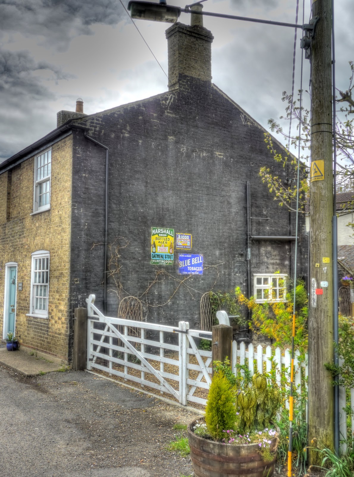
Opposite the adverts was this rather quaint Thatched Cottage looking good in the sun with the bright colours in the strip of garden at the front. Did I also mention that the road from Somersham was much more pleasant to cycle along, although still the same road number it was less straight and not so busy. Consequently cars tended to give more space and pass me with more room.

Just in case you could not see the adverts here they are again in close-up. Until I saw the sign I had never heard of Marshall Oatmeal Stout.

After Earith I ended up heading north again, towards Sutton. in the Isle - a village a little like Ely in the sense that it is situated on a hill with lower level land surrounding it - a little like an island. Sutton lies just off the very busy (and to be avoided) Ely to Chatteris (A142) main road - but it looked as though there was a by-way that meant I could avoid the busy main road, the byway then came out on the Haddenham Road with although an A road was not busy and apart from having to cross the A142 - which was tricky, it was a very pleasant route.
The byway ended up passing between fields of Oilseed Rape - although the clouds did look a little ominous.

I took this picture looking back at Sutton to try to convey the idea that the Village was an island surrounded by a sea of yellow. You can see the church tower but the ridge is not as high compared with the surrounding land compared with Ely.

Just where the Sutton byway joined the A1421 there was an interesting path that I took a picture of as a possible future route to explore. (Both on the map and on the bike.)

Once I was on the main road (A1421) heading north I stopped to take a picture of the church in Sutton using a convenient lamp-post to steady the camera.

Where the A1421 joined the A142 it is shown as Witcham Toll on the map. My plan was to cycle into Witcham and follow one of the many by-ways to Coveney.

There was a convenient plaque showing the area, but although I went over to several different byways, but either I was too tired or they really were too bumpy but after a short trip up each of them I found them way too bumpy on my hybrid bike and took the road route instead.

Then after Coveney I popped over to Ely and followed Sustrans 11 back to Burwell. A quick stop to admire the neatly planted rows in this field with a sprinkler in the background. Whilst passing one of these fields I am also sure I heard a "rookie". When I was a boy farmers used a string of fireworks (bangers on steroids) which as the string smouldered would explode from time to time to scare birds. The name rookie derives from the name Rook Scarers We used to pretend we were buying them, for our farmer Dads, because they were more powerful the normal fireworks - we were lucky no-one got hurt.

Through the back of Wicken a nice piece of targeted marketing - this is a Sustrans route - so why not appeal to Cyclists - who generally are happy to take any opportunity for a cake stop.

After cycling through Wicken Fen I saw this "abandoned" tractor and rollers - kind of strange - was the farmer abducted by aliens.

In the end I cycled around 100Km/60miles and despite breaking my rules about cycling home into the wind it was not too challenging. I found also some new byways to cycle on. The only niggle was the battery in the transmitter on my speedometer went flat so about halfway round it stopped showing my speed and recording the total distance. Not too much of a problem though as my Garmin GPS unit recorded the the route, and speeds. I only got wet three times and each time it was a relatively short shower so for once the weathr forecasters also got it right.
No comments:
Post a Comment