
This is part 2, but for ease of reference I have included the map of the ride and here is the Bike Route Toaster (BRT) Link. The order of the ride on BRT shows me starting in Ely and cycling down to Cambridge and then up to King’s Lynn. – I only did that so the ride would show as one contiguous ride for distance and elevation mapping. This was my longest ride of the year – around 136Km/85 miles. It is a remarkably flat route though, at the maximum the elevation is 34m (and the minimum is –1m).

At this point the road (B1411) has just started to run parallel with the New Bedford River (aka Hundred Foot Drain) where it is known as the Hundred Foot Bank. This is the view looking back down the B1411. Ahead the road passes under the Ely to Peterborough Railway Line and one or two cottages and farms as well as passing the Hundred Foot Pumping Station.

This is a picture from Wikimedia.org taken from the side I assume.

Again, another Wikimedia picture - I rather like the “poem” although I think that the aims are somewhat ambitious give the power of nature.

For a brief distance the road alongside the New Bedford River is joined by the A1101. Although technically the B1411 joins the A1101 – at the same spot there is a road sign welcoming you to Nelson’s Country – Norfolk. As I was cycling along here I did think that the road, whilst being a main road, was not that bad. It was straight, but it wasn't that busy and when I was overtaken the cars/vans always gave me plenty of room. I also passed an older couple cycling the other way on this stretch.

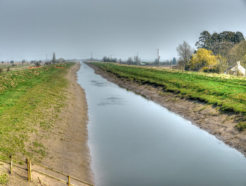
The NCN11 route continues alongside the New Bedford River, whilst the main road swings off west through Welney. This picture was taken near Suspension Bridge looking up the river. It looks rather empty to me. The place appears to be called Suspension Bridge rather than I was on a suspension bridge. I was on a bridge though.
NCN11 carries on past the Welney Wetland Centre before a bit of zig-zagging east towards Ten Mile Bank. If you follow the link to their history page you will see that in 2010 the River Great Ouse froze for the first time in over 30 years.
This is the land of “wide open skies”, the fields are large and flat and there are not a whole load of trees. This freshly ploughed field seems to stretch away almost to the horizon.

When you reach Ten Mile Bank the route heads up alongside the River Great Ouse more or less all the way. Although switching sides at Denver. There are a series of locks and the River Great Ouse joins with the New Bedford River and then a large parallel relief channel splits off. This is the view up the Relief Channel at first I thought it was the King’s Lynn Power station, but the channel is not that straight. I think that is Hythe Bridge on the outskirts of Downham Market and that the buildings are part of a factory complex. With a bit of web-sleuthing. Well actually I used Google Satellite view to find the place (it was the silos that gave it away) and then went down to Streetview to see the name of the operation. I think it is Heygates Mill at Downham Market. Apparently they have over 50 staff and produce around 90,000 tons of flour per year.

I was standing on the Sluice Road when I took that last picture and this one. I also seem to have found what might be a casualty of the budget cuts. A web search brought up the Official guide to Anglian Waterways – www.visitgreatouse.co.uk – closed as of 31st March 2011. At the moment there is still a cached version held by Google (and I presume it would be archived?). Here is the Wikipedia webpage – with a little history on the sluice. A quick check and no, the website was not archived under the wayback machine, here is an link to the Fens Waterways Link – with plans to open up more waterways. The sluice, or some part of it is a listed building. (Here is an old map.)

NCN11 moves away from the water as it heads through Denver to Downham Market. One of the landmarks as you approach Denver is Denver Mill, apparently the last commercially working Windmill in Norfolk.

NCN11 has its own route through to Downham market including a shared-use bridge over the A1122 along a track known as Nightingale Lane (a track) shown here just after coming of the bridge.

This is the view back of the bridge. I would imagine this also makes a good route through to the School from Denver. The A1122 is below.

As you carry on up NCN11 there is a bit of weaving around Downham Market and although you are not really far from the Great Ouse Relief Channel you don’t realise how close you are. The route passes some interestingly names places: Wimbotsham, Thorpland and Runcton Holme. It then passes through Watlington before heading alongside the Relief Channel again.
This channel crosses under the road and heads into the Relief Channel and seems to have the name Plover further upstream. You can’t actually see the Relief Channel here despite its proximity.

NCN11 and NCN1 then combine to head towards King’s Lynn. A little further up I stopped at this point to nip over onto the Saddlebow Bridge to take a picture of the King’s Lynn Combined heat and Power Station, which you can see here on the right and is where our route takes us.

If you follow the NCN11 route as marked on the “ground” it heads around to the left of the Power Station, approaching it from High Road, whereas the route shown on the current OSM Cycle map shows it passing along Low Road. I generally take the High Road although you can take the Low Road. I prefer the route I took as it is mainly off-road once you reach the Power Station. This is the view from round the back.

NCN11 then carries along by the side of the River Great Ouse where it heads towards Boal Street. The current maps are out of date as a new bus lane has been constructed. Or as the Daily Mail puts it – “Bungling council unveils £1.5m bus lane… only it’s too narrow for BUSES”. Apparently one of the Bus Companies – “First has declined to use it”. Here it is – I didn’t decline to use it, nor did these other cyclists – but it does strike me as a very odd bit of road- what were they thinking?

I generally follow my own route around King’s Lynn past the South Quay and then back to the Railway Station (Wiki entry for the Station here). After buying my ticket and checking that I had time I popped into the cafe and got a sausage sandwich to eat on the train. (The ticket was £6 – single from King’s Lynn to Ely.) When the ticket inspector came around he checked that I realised I only had a single ticket – an odd sight to see a cyclist only going one way perhaps?
I must admit I struggled to stay awake on the short train journey (30minutes). Although everyone in the carriage got a shock when my bike tumbled to the floor. It doesn’t happen all the time – but there are no dedicated spaces for bikes and you have to try to jam them. Nothing got broken, although my Longstaff suffered a bit of minor damage once.
When I arrived at Ely the morning seemed long forgotten – partly because the weather was a bit gloomy. There were a bunch of rowers heading towards Ely on the River Great Ouse. There were two groups each had a motorboat following them. Then there was one straggler who looked a bit dejected.

Once back to Wicken I followed Lodes Way with a detour through Burwell. In fact it started raining, and whilst going through Burwell the rain got even heavier. I was wondering whether to stop and put on my rain jacket or carry on. In the end I carried on and then sheltered in one of the culverts under Reach Lode Bridge and had a drink and a few jelly babies. The rain is one of the reasons the pictures stop until just before White Fen, in fact just before the Swaffham Bulbeck Lode Bridge to take a picture of this misty field. The recent rain on the warm soil caused a bit of mist to rise.

That has to rate as a really pleasant cycle ride out. No wind, warm and pleasant, even the rain didn’t dampen my spirits. I forgot to mention that I was chased by a flipping dog on my way out along Lodes Way near Burwell Lode – if you can’t train a dog you shouldn’t have one is my feeling on the matter. During the day I also passed quite a few cyclists including a family out together, a chap making deliveries with a trailer cycle and a couple of old folk. Mind you the old folk actually looked pretty fit and well-sorted cyclists. (And a sausage sandwich.)
No comments:
Post a Comment