
This is one of those lazy summer day cycle jaunts - I was not in a hurry, I was not bothered about exploring, but I did want to get away from busy roads. So I set off with a rough direction in mind and a map - yes a real paper map. My tatty Cambridge & Newmarket OS 1:50K map, with a 1981 copyright, was a little out of date but I wanted something that gave me a better perspective on where I was relative to the surrounding countryside. The map on my GPS is ok - but it has a small screen and when zoomed out hides a lot of detail which makes it less good for generally cycling along in a rough direction. The out of date OS map could bring some context to where I was and what roads/tracks would be appropriate for heading in a general direction. My starting point for a direction was to head out of Great Wilbraham along a byway to the North-East and then pick up another byway towards Westley Waterless.
This is the route I eventually followed - shown below and is available at this BikeRouteToasterLink. The route meandered a bit and according to the summary information on BRT is just over 73Km in length with 279m of climbing and reaches the dizzy heights of 117m above sea level. It was quite sunny so I took some sunscreen with me, just in case I started to go red. Mind you my arms and legs are sufficiently brown now that unless there is direct midday sun I don't bother putting on sunscreen unless I am planning on a day ride. However I do take the sunscreen just in case and have had to use it on one or two occasions mid-ride.

After cycling out of Great Wilbraham this is the byway, not a soul in sight, a firm track and a blue sky what could be better than that for an afternoon's ride. The camera does make it seem longer than it is - there is a dip and then a road to cross - actually it is quite an unpleasant road to cross - it is a country lane (Wilbraham Road) and straight with some slight bends with adverse cambers and in my experience cars whizz along. So you have to stop and look before crossing the road onto the byway the other side. On the 1930s OS map the byway was called Streetway.

The route then joins the Heath Road byway. This used to be a crossroads of byways according to the 1930s map, but when the A11 was built (or perhaps when it was turned into a dual carriageway) there would have had to have been two byway bridges built close to each other to accommodate the two byways. Consequently they diverted one byway and created an alternate route alongside the right hand side of the A11. The Heath Road continues over the A11 and crosses the A1304 before a gravel track where it crosses the Cambridge to Ipswich Railway Line. The crossing is not controlled you check some lights and then push through a gate for those crossing on foot on either side. The track then becomes a country road and climbs up hill.
The hill is called Cambridge Hill and here it is in this, the road is the other side of the hedge on the right of the picture. At this time of year, especially with all the dry weather, the fields all look brown with the odd green strip from hedgerows or clumps of trees.
After reaching the top of the hill instead of cycling to Westley Waterless I headed right and then took the Icknield Way Trail to the East, where it met the B1052 but I turned off after a brief spell on the road and headed along another byway - Brook Lane. This byway started off as a gravel "road" heading down hill - not too bad but some care was required with the lumpier stones and the odd stick on the path. Looking at the map there are a few byways/bridleways that lead off this path that would be worth exploring another time.
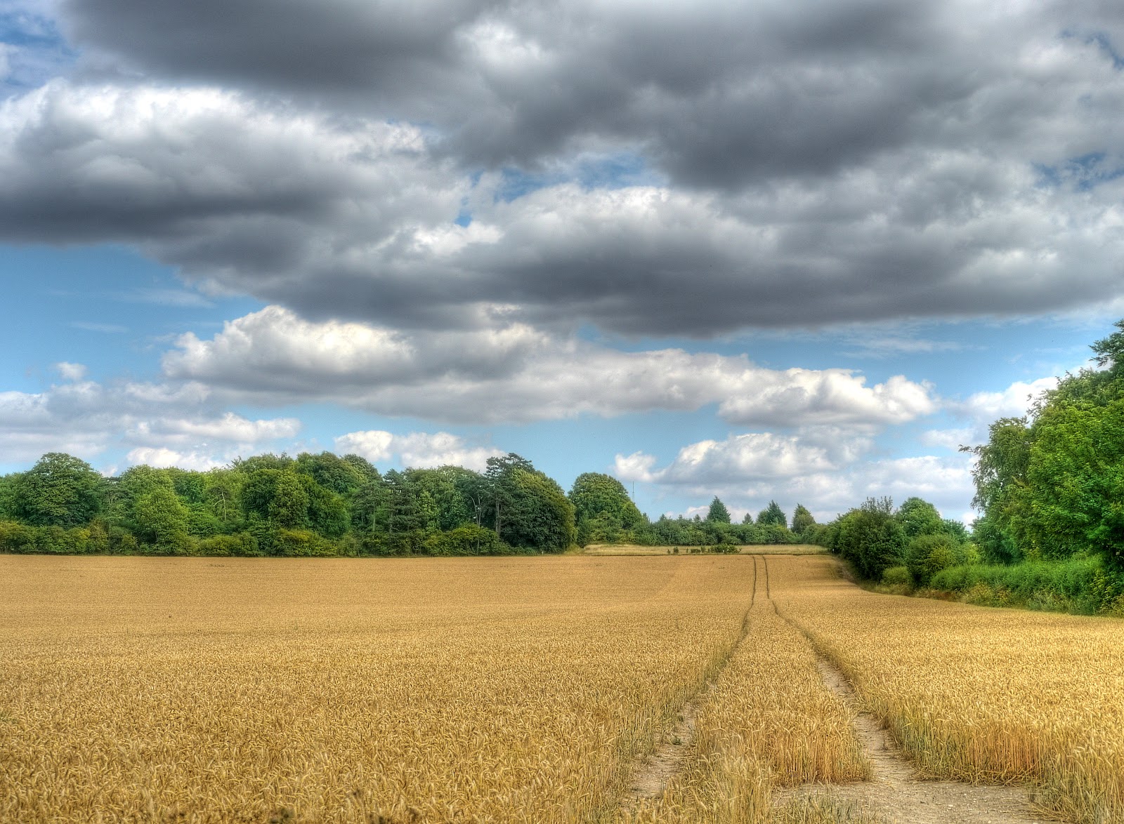
Somewhere on along the byway I took this picture. I can see from my GPS trace the point where I stopped to take the picture, but when I look at the same place on either the OS map or using Google Earth I can't see the house nestling amongst the trees. Never mind - I took the picture of the Combine Harvester and the neat stripes left behind. Because the Combine was moving this is a single exposure picture - but with a bit of Photoshop Elements tweaking to make the clouds in the sky look a little more visible.

The same view - but this time using an HDR multiple exposure and without the Combine Harvester in the shot as it would have moved between the 7 different exposures and so appeared as a blurred mess.

The byway ended up at Weston Green. This byway connects to the road via a Ford, however despite my recent experience of cycling along the slightly flooded CGB I decided to use the bridge alongside. It seems that quite a few byways in the Flatlands have an access restriction of some type. In the picture you can see open gates and the back of a sign. I believe this Byway is closed from 1st October to the 30th April with the exception of Pedestrians, equestrians, pedal cycle-arians and permit holders. The County Council keep a list of them here, which might be worth checking for interesting routes.

The byway seems to go through an area called Three Horseshoes and after the Ford leads onto a short road - Horseshoe Lane, where short means less than 200m long. On the one side is a recreation area with playground and cricket nets and on the other side are houses. so why does it have a 40MPH speed limit. I would have thought this was a street more suited to a 20MPH limit with kids playing in it.

I then cycled along various roads including Common Road though Carlton and then to Burrough Green which seems to have loads of footpaths but only to byways. I have cycled on both byways in the past this time I went North past Gipsy Hall through Dullingham Ley and then up another byway to Woodditton. Whilst just checking my route on the map I noticed that there there is a route from Great Bradley through to the Woodditton Road called the Stour Valley Path which is shown with green dots (on the 25K map) and so cycle-able with another track through Kirtling to Little Ditton. So even though I did not really cycle on new tracks this times around it has thrown up some interesting possibilities for a future ride.
Back to this route - the Water Tower at Woodditton is a useful landmark, shown here and marks the byway which runs almost parallel with the Devil's Ditch which is a footpath and so not cycle-able.

The byway skirts around Camois Hall with a few horses in the fields and and follows a farm track past a strip of trees. The track is pretty good for a hybrid bike. To the left of the picture is a strip of green that is the route of the Devil's Ditch. The valley in the middle is Dane bottom with a footpath connecting this byway with the Devil's Ditch. There were a couple of hikers on the footpath heading towards the "ditch".

The bridleway crosses a road before emerging on the B1061 next to a pumping station. This was the most unpleasant road of the route. A large Mercedes estate whizzed by rather too close for my comfort and it was surprisingly loud. I guess that luxury cars are assumed to be quite because they are quiet when sitting in them because of all of the sound-proofing. You'd be surprised (well the driver and passengers would be) at how noisy they are roaring along at 60MPH ON THE ROAD. In Newmarket In Newmarket the Taxis are distinctively painted in yellow and black. One passed me much closer than the Merc driver, it was if he had not seen me! If I had not been so shocked I would have taken his number and complained - but it was so close I stopped.
Newmarket itself is on the route of Sustrans 51, but I passed through and on to Exning where I used the byways (Haycroft Lane and Howlem Balk) to get to Burwell. This is Haycroft lane - it is pretty overgrown at the moment - you can't really see the track for long grass - it is a nice route though and I almost never see anyone on the track.

I almost forgot to mention that I almost succumbed to one of the problems of cycling in the Summer. I swallowed a fly - or rather a fly went in but lodged somewhere halfway down my throat - I wasn't sure whether to swallow it or spit it out. Neither tactic worked at first - I had to stop in order to be able to properly "hawk" it up.
The route was a pleasant one and easy to cycle in fine weather - bits of it can be a challenge (for me anyway) on a hybrid bike.
No comments:
Post a Comment